

MT HOOD SNOW FORECAST

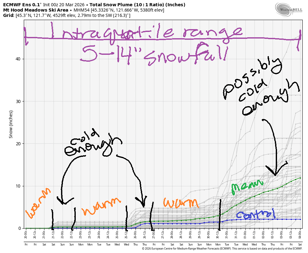
Hey skiers and snowboarders! Ma Nature seems to have put a fork in winter, but that doesn’t mean you have to stop shredding. Shred as much as you can until it’s gone! Between now and the end of the month, the intraquartile range has only 5-14” snowfall. We can’t totally rule out an April miracle, but the last few years have not been kind to the snowpack in April.
Short term Mt Hood snow forecast
Looking at Friday, we have a partly cloudy start with increasing clouds in the afternoon and the possibility of a little drizzle (0.15” tops) overnight. Temps max out in the upper 40s at 5000′ today. The snow level will be 11,000′ this morning, 5500′ this afternoon, and 1500′ after midnight. Most of the precip will be drizzle. A trace of snow is possible at 5000′. Wind today will be SW 20-35 this morning, WSW 25-30 this afternoon, and W 25 after midnight. Snow surface: partially refrozen granular quickly softening to spring conditions.
Saturday starts out clear and sunny and stays that way. The free air freezing level (FAF) will be around 1500′ in the morning, 3000′ in the afternoon, and 2500′ after midnight. Snow surface: frozen granular in the morning and corn in the afternoon. Temps rise to the upper 20s or low 30s at 5000′. Wind will be W 25 in the morning, NW 15-20 in the afternoon, and NW 10-15 after midnight.
Extended Mt Hood Snow Forecast
On Sunday, we’ll have sunshine yet again. The FAF will be around 2500′ in the morning, 7000′ in the afternoon, and 8500′ after midnight. Afternoon temps rise to 40F at 5000′. Wind will be NW 10-15 in the morning, light and variable in the afternoon, and SW 5-10 after midnight.
Dry, relatively warm weather continues on Monday with high clouds, light wind, and temps in the upper 30s. A weather system is forecast for Tuesday into Wednesday. Models are all over the place on the amount of precip accompanying this system. Most of the precip, unfortunately, will be rain. If we get really lucky, the 5000′ level could pick up 3-6” snow in the tail-end orographic situation. “Lucky” is the operative word here. Fingers crossed.
Beyond that system, we’re looking at another dry/warm spell until next Thursday/Friday. Beyond next Saturday, uncertainty is too high to make any sort of meaningful predictions, so I”ll leave it here for now. Get some warm wax on your boards and hit the slopes while we still have snow to shred. See you on the slopes!
Was that helpful? I knew it was! Guess what? All of this crucial work – from your personal wind and snow reports to the invaluable TATAS updates – is made possible by my relentless efforts. Maintaining this labor of love isn’t easy. Each daily forecast takes hours. Website hosting, weather model access, and back-end admin work takes time and money. That’s where you come in.
YOUR CONTRIBUTION MAKES A DIFFERENCE
- SUPPORT ACCURATE, HYPER-LOCAL WEATHER FORECASTING
- ENABLE ACCESS FOR ALL, EVEN THOSE WITH LESS MEANS
- SUPPORT A COOL HUMAN WHO WORKS HARD SO YOU CAN PLAY
Take a moment to click one of the buttons below. Donate $19.99 or more (how much does this forecast enhance your life?) and get the email in your inbox. Whether it’s a renewing subscription (auto-renew) or a one-time donation, every contribution makes a real difference. Help me keep this labor of love alive, so we can all continue playing, commuting, and living in the Gorge with peace of mind and the best weather forecasts possible. Thank you!


Hood River, Oregon 97031


GORGE WIND FORECAST
If you’re still seeing yesterday’s and it’s after 9am, try opening this in an incognito window
SHORT-TERM gorge wind forecast
Hi friends! It’s officially spring, the water temp is 45.7F, and the air temp plus the water is over 100F. That’s an arbitrary number, but one used by many to decide if it’s “warm enough”. That, of course, is a personal decision, and you’ll have to make it yourself. But if you’re considering going out, you have a couple chances coming up.
Friday kicked off glassy as can be in Hood River. Pressures were 30.11/30.08/30.05 and the wind was generally light/variable all through the Gorge. An approaching cold front this afternoon will drive the wind upwards. By late morning, we’ll have gusty 15-18 from Stevenson to The Dalles and also at Rufus. From mid-afternoon on, there will be drizzle west of Viento; westerlies drop to 13-16ish from Stevenson to Doug’s. Drizzle makes it to Hood River around 5pm; there a chance of a short burst of stronger wind ahead of the rain. East of The Dalles, you’ll find gusty 24-27 from Avery to Boardman for a few hours mid-afternoon. After 5pm, the wind drops off everywhere. River flow over the last 24 hours was 172-210kcfs, river temp is 45.7F, and high temp forecast is 66F with cloudy sky.
RIVER FLOW FOR SITES BETWEEN AVERY (EAST OF THE DALLES) AND RUFUS: CLICK HERE FOR JOHN DAY DAM FLOW.
RIVER FLOW FOR SITES BETWEEN STEVENSON AND DOUG’S BEACH (WEST OF THE DALLES): CLICK HERE FOR THE DALLES DAM FLOW

LONGER-TERM gorge wind forecast
The cold front clears the Gorge early Saturday, and high pressure builds offshore. A weak onshore thermal gradient assists our wind. TJ’s dawn patrol should be firing with 24-27 from Viento to Mosier (less in Hood River) and 18-21 from Lyle to Rufus. The wind dips mid-morning. For the afternoon, we’ll have 19-22 from Stevenson to Hood River with 22-25 from Mosier to Avery and 13-16 at Rufus. Rufus builds to 22-25 in the afternoon, and the Stevenson-Mosier stretch fades to 15-18. All that said… models currently suggest low clouds will dissipate west of Hood River in the afternoon. If that doesn’t happen, the wind will exceed this forecast. High temp: 55F with partly cloudy sky to start and mostly clear sky to finish.
High pressure builds inland on Sunday. We start with light onshore gradients and little to no accompanying wind. Dead calm conditions are forecast midday before an easterly bump. Stevenson maxes out at 15mph before dropping to 10mph late afternoon. Iwash (Rooster) Rock doesn’t do much at all. High temp: 58F with increasing clouds. Upper teens are possible but not promised at the Hatch on Monday. A cold front approaching sometime Tuesday gives us another shot at west wind, but it’s looking like the strongest wind may happen overnight. Beyond Tuesday, significant model uncertainty is present. So that’s it for now. Hope to see you out there Saturday morning at the Hatch!

BARE BONES HOOD RIVER WEATHER FORECAST
Partly cloudy this morning. Cloudy this afternoon. Rain this evening. Temps start in the low 50s and rise to the mid 60s. Light westerlies early. Moderate later. No rainbows. Saturday will be partly cloudy then mostly clear. Temps start in the mid 40s and rise to the mid 50s. Strong westerlies. No rainbows. Sunday will be partly Nothing then partly cloudy. Temps start in the low 30s and rise to the upper 50s. Light and variable wind. No rainbows.
TEMIRA’S AWESOME TRAVEL ADVISORY SERVICE
HYPERLOCAL WEATHER FORECAST FOR THE COLUMBIA GORGE
THE DALLES, HOOD RIVER, WHITE SALMON, TROUT LAKE, STEVENSON, CASCADE LOCKS, PARKDALE, ODELL, HUSUM, BZ, MILL A, WILLARD, GOLDENDALE, RUFUS, ARLINGTON, boardman
Good morning, neighbors! Happy spring! It’s official! We made it! Winter is over! It never really started, but now it’s officially done. For the next couple of weeks, the weather looks positively spring-like. Temps bounce around all over the place, but there are no signs of weather impacts other than a chance of frost on Sunday morning. Before we stick a fork in winter… remember that we had snow on April 8th a few years ago!
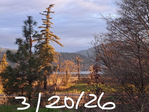
Glenwood this morning
Glenwood is convinced the calendar says “summer” this morning – it was 54 (!!!) degrees there to start today. This is probably the first winter ever where nobody’s pipes froze in Glenwood. I’m assuming nobody’s pipes froze, anyway, and they sure as hell won’t freeze today. Other news: no ice, and no !CE this morning…
Today’s Gorge weather forecast
The closest we’ll get to winter today is a bit of drizzle this afternoon. After a cloudy start, rain arrives in Cascade Locks around 11am, Hood River around 5pm, and Rowena around 8pm. To the east: dry and breezy. West side westerlies pick up to 25-30mph this afternoon. West of The Dalles: 15-20mph. Temps max out at 66F (west), 70F (The Dalles) and 76F (The Desert, where the watermelons are stirring in response to the heat).
Saturday’s Gorge weather forecast
Overnight, much cooler air arrives. Above 1500′, temps will be right around freezing. Below: thanks to a strong westerly breeze to start the day, temps will be well above freezing, in the low to mid 40s. After a partly cloudy start, the sky turns mostly clear. Temps climb to 55F (west), 58F (The Dalles), and 63F (The Desert). Wind will be 25mph west of Lyle to start the day and 20mph form Lyle to Rufus. Afternoon brings 15-20mph west of Mosier and 25mph from Mosier to Rufus.
Sunday’s Gorge weather forecast
That wind shuts down Saturday night as high pressure settles inland. We’ll start Sunday chilly (850mb temps at -1C), clear, sub-freezing for many areas, with a tiny partial Nothing cloud near the Nch’i Wana. Glenwood dips into the low-mid 20s. Upper Valley: upper 20s to low 30s. Lowlands: 31-35F. By afternoon, everyone turns partly cloudy. Max temps will be near 60F all across the lowlands. Wind will be light and variable with max readings at 15mph near Stevenson.
Extended Gorge weather forecast
Monday: not much to say. High clouds combine with moderate west wind and highs right around 60F. A weather system arrives sometime on Tuesday with some rain (amount TBD) some wind (timing and strength TBD) and maybe a few inches of snow for the mountains (if we’re really, really lucky). Beyond that… warmer again for a few days, then cooler, then really uncertain starting next weekend but unlikely to cause any travel issues. Safe travels. -TATAS
HEY! DON’T STOP READING! Is this community-focused forecast helpful to you? It sure is! It takes me a couple hours a day to write. Please join your friends and neighbors in contributing to keep it going. Venmo: @thegorgeismygym PayPal: twomirrors@gmail.com USPS: Temira / PO Box 841 / Hood River, Oregon 97031 You can test out the forecast subscription for a few days for free by signing up below. Easy! Do it!
JONES BEACH, SAUVIE ISLAND, & COAST FORECAST
ON WINTER VACATION UNLESS DESPERATELY NEEDED.

Leave a Reply