

MT HOOD SNOW FORECAST

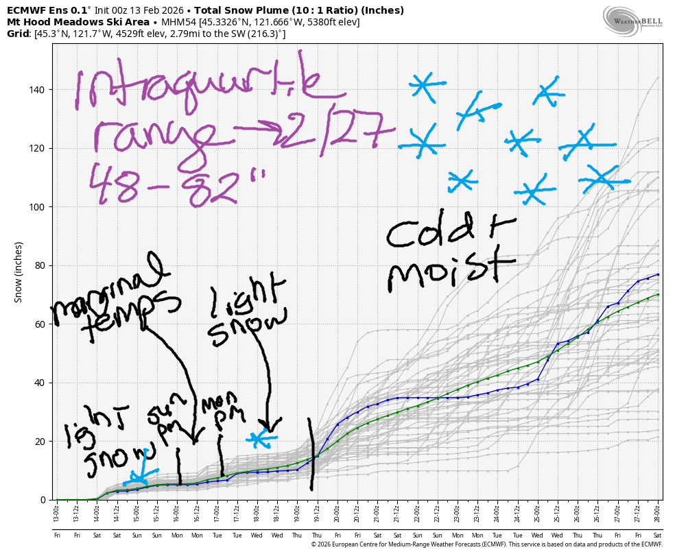
Hey skiers and snowboarders! Feels like I keep saying, “Winter’s just around the corner,” but it really does appear to be true this time. It’s Friday, and we’re going to pick up some snow tonight and a little more on Saturday. Temps look marginal on Sunday, but there won’t be much precip about. Ditto about the temps on Monday – the snow level may jump up to 5500-6000′ briefly – but again, not much precip. Cool, showery weather this week allows for intermittent light snowfall. Starting next weekend, snowfall rates (probably) accelerate. Through 2/27, the intraquartile range is 48-82” of snow, and temps look to stay below freezing at 5000′ for that entire time period. Finally!
Short term Mt Hood snow forecast
Looking at Friday… we have a cloudy start to the day thanks to an approaching weather system. Snow arrives mid to late afternoon. The snow level will be 3000′ this morning, 3500-4000′ this afternoon, and 2500′ after midnight. About 0.5” water equivalent (WE) is forecast tonight for around 5” of medium-density new snow at 5000′. Temps today max out around 30F. Wind will be SW 5-10 this morning, SW 10-20 this afternoon, and W 20 after midnight.
Flurries Saturday morning give way to clouds midday and light snow overnight. The snow level hovers around 2500′ all day and drops to 2000′ overnight. Just a trace of snow is forecast in the morning, and just an inch of snow is forecast overnight. Wind will be W 20 early, variable to 15 in the afternoon, and SSW 10-20 overnight.
Extended Mt Hood Snow Forecast
Sunday may see a few wet flurries, but no accumulation is forecast. The snow level will be 2000′ early and will rise to 4500′-5000′ in the afternoon as temps max out around 33F at 5000′. Wind will be light and variable all day rising to S 10-20 after midnight.
Light (wet) snow is forecast on Monday with the snow level rising to 5500′ before dropping to 1000-1500′ overnight as a cold front arrives. Up to 2” new snow is forecast. Wind will be less than 20mph all day and will rise to SW 15-25mph overnight. Cooler weather follows this Monday system. We’ll see instability-driven snow showers through the middle part of next week with the snow level staying well below the passes. Sometime late next week, a more assertive pattern develops, and this (almost certainly) sets us up for heavier snowfall. Please let it be so! See you on the snow!
Was that helpful? I knew it was! Guess what? All of this crucial work – from your personal wind and snow reports to the invaluable TATAS updates – is made possible by my relentless efforts. Maintaining this labor of love isn’t easy. Each daily forecast takes hours. Website hosting, weather model access, and back-end admin work takes time and money. That’s where you come in.
YOUR CONTRIBUTION MAKES A DIFFERENCE
- SUPPORT ACCURATE, HYPER-LOCAL WEATHER FORECASTING
- ENABLE ACCESS FOR ALL, EVEN THOSE WITH LESS MEANS
- SUPPORT A COOL HUMAN WHO WORKS HARD SO YOU CAN PLAY
Take a moment to click one of the buttons below. Donate $19.99 or more (how much does this forecast enhance your life?) and get the email in your inbox. Whether it’s a renewing subscription (auto-renew) or a one-time donation, every contribution makes a real difference. Help me keep this labor of love alive, so we can all continue playing, commuting, and living in the Gorge with peace of mind and the best weather forecasts possible. Thank you!


Hood River, Oregon 97031


GORGE WIND FORECAST
If you’re still seeing yesterday’s and it’s after 9am, try opening this in an incognito window
SHORT-TERM gorge wind forecast
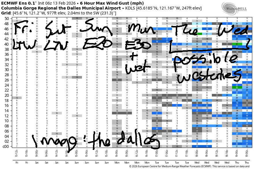
Hi friends! Not much happening over the next five days. Towards the end of next week, there’s a possibility of stronger westerlies as the weather turns more active, but models are far from certain about us getting a big west wind day.
Friday started of with dead calm wind and pressure of 30.18 all across the Gorge. The wind will be light and variable this morning. Ahead of an incoming weather system this afternoon, westerlies rise to 10-13mph from Stevenson to Viento. Elsewhere: light. River flow over the last 24 hours was 140-196kcfs, river temp is 41.4F, and high temp forecast is 48F.
RIVER FLOW FOR SITES BETWEEN AVERY (EAST OF THE DALLES) AND RUFUS: CLICK HERE FOR JOHN DAY DAM FLOW.
RIVER FLOW FOR SITES BETWEEN STEVENSON AND DOUG’S BEACH (WEST OF THE DALLES): CLICK HERE FOR THE DALLES DAM FLOW

LONGER-TERM gorge wind forecast
Saturday starts with very light west flow and then turns calm. High temp: 47F with morning and afternoon drizzle. Sunday looks a little windier: the day starts with E 25mph at Iwash/Rooster and 15mph at Stevenson. Both those spots level out at 15-20mph and hold into the afternoon. High temp: 47F under partly cloudy sky.
Monday looks like a (wet) east wind day, perhaps 20-30mpm. Tuesday brings light westerlies. As we move towards the end of next week, the weather becomes more active. With low pressure systems moving around the region, we might get lucky enough to have one swing across the Cascades and turn on some eastern Gorge west wind Wednesday, Thursday or Friday. No guarantees. Stay warm out there!
BARE BONES HOOD RIVER WEATHER FORECAST
Clouds this morning. Rain mid-afternoon on through the night. Temps start in the mid 30s and rise to the upper 40s. Light westerlies. 2% chance of rainbows. Saturday will be rainy early, dry most of the day, and drizzly overnight. Temps start in the upper 30s and rise to the mid-upper 40s. Light westerlies. 67% chance of rainbows. Sunday will mostly cloudy then partly cloudy. Temps start in the upper 30s and rise to the upper 40s. Light easterlies. 3% chance of rainbows.
TEMIRA’S AWESOME TRAVEL ADVISORY SERVICE
HYPERLOCAL WEATHER FORECAST FOR THE COLUMBIA GORGE
THE DALLES, HOOD RIVER, WHITE SALMON, TROUT LAKE, STEVENSON, CASCADE LOCKS, PARKDALE, ODELL, HUSUM, BZ, MILL A, WILLARD, GOLDENDALE, RUFUS, ARLINGTON, boardman

Good morning,neighbors! TGIF! It’s Friday the 13th, and it’s all going to go to hell today due to it being an unlucky day. Or perhaps our luck will change, and this Friday the 13th will be the one that changes everything for the better! Upcoming changes for the better: a cooler, moister weather pattern for the next two weeks that gives a boost to the seriously sad mountain snowpack. We’ll even have a chance for some mid-elevation (1000-1500′) snow flurries this week. If we get really (un)lucky, we could pick up a little freezing rain Monday morning and/or low-elevation snow at some point in the next couple of weeks. No clear signs of that in the models for now, and no signs of a significant winter weather event for the Gorge.
Glenwood this morning
Looking at Friday morning, we’ve got cloudy sky. Most of us are above freezing, but guess who’s below freezing? GLENWOOD! 28 degrees there to start the day. Good job, team! Everyone in Glenwood is knitting red Norwegian hats, which is why you can’t find high-quality red yarn anywhere. RESIST! Speaking of… no signs of !CE in the Gorge today.
Friday Gorge weather forecast
After a mid-30s start most places on Friday, temps rise to the upper 40s in the lowlands. The snow level will stay above 2500′, so the incoming rain shouldn’t cause problems. Rain arrives for areas west of Mosier by 4pm. This evening, you’ll encounter moderate to heavy rain in the usual 84/14 heavy rain zone. East of Rowena, everyone stays dry tonight, except for the southern parts of Sherman and Gilliam Counties, where drizzle is possible. Wind is a non-issue today; after a calm start, it rises to W 10mph west of Hood River.
Saturday’s Gorge weather forecast
Clouds linger Saturday. Morning drizzle west of Mosier gives way to dry weather midday. Rain returns late afternoon and makes it as far east as Hood River. East of there: dry, again. Saturday’s highs rise to the upper 40s west of The Dalles and nearly 50F out in the desert lowlands. Overnight, the snow level falls to 2000′, so a few of you may see a few flurries. Clouds stick around overnight, which limits the formation of icy roads. Can’t totally rule out some slick spots, but they’ll be up high, not down low.
Sunday’s Gorge weather forecast
Mostly cloudy sky starts Sunday, but we’ll finish with lots of sunshine. Morning temps: upper 30s. Afternoon: upper 40s. East wind 15-25mph in the usual east wind spots: Stevenson, Iwash (ding-dong) Rock, Home Valley. Another round of steady rain is forecast late Sunday night into Monday. If the clear sky lingers long enough Sunday night, some areas (Stabler, Trout Lake, Parkdale, BZ, Mill A, Snowden, Glenwood, High Prairie, Appleton) could pick up a little freezing rain. We’ll watch this closely. Temps should warm up quickly and mitigate any problems.
Extended Gorge weather forecast
Cool, showery weather sticks around for the middle part of next week. We’ll be under the influence of a much colder regime (but not as cold as the federal one) all week long. This leads to a few flurries above 1000-1500′ and the possibility of icy roads. Details will become more clear as we get closer. The latter part of next week has some potential for heavier precipitation. Up in the mountains: definitely snow. Here in the Gorge: potential for snow in our higher-elevation communities. Know why this is happening? Because I planted peas. You’re welcome. Safe travels. -TATAS
HEY! DON’T STOP READING! Is this community-focused forecast helpful to you? It sure is! It takes me a couple hours a day to write. Please join your friends and neighbors in contributing to keep it going. Venmo: @thegorgeismygym PayPal: twomirrors@gmail.com USPS: Temira / PO Box 841 / Hood River, Oregon 97031 You can test out the forecast subscription for a few days for free by signing up below. Easy! Do it!
JONES BEACH, SAUVIE ISLAND, & COAST FORECAST
ON WINTER VACATION UNLESS DESPERATELY NEEDED.
