

MT HOOD SNOW FORECAST

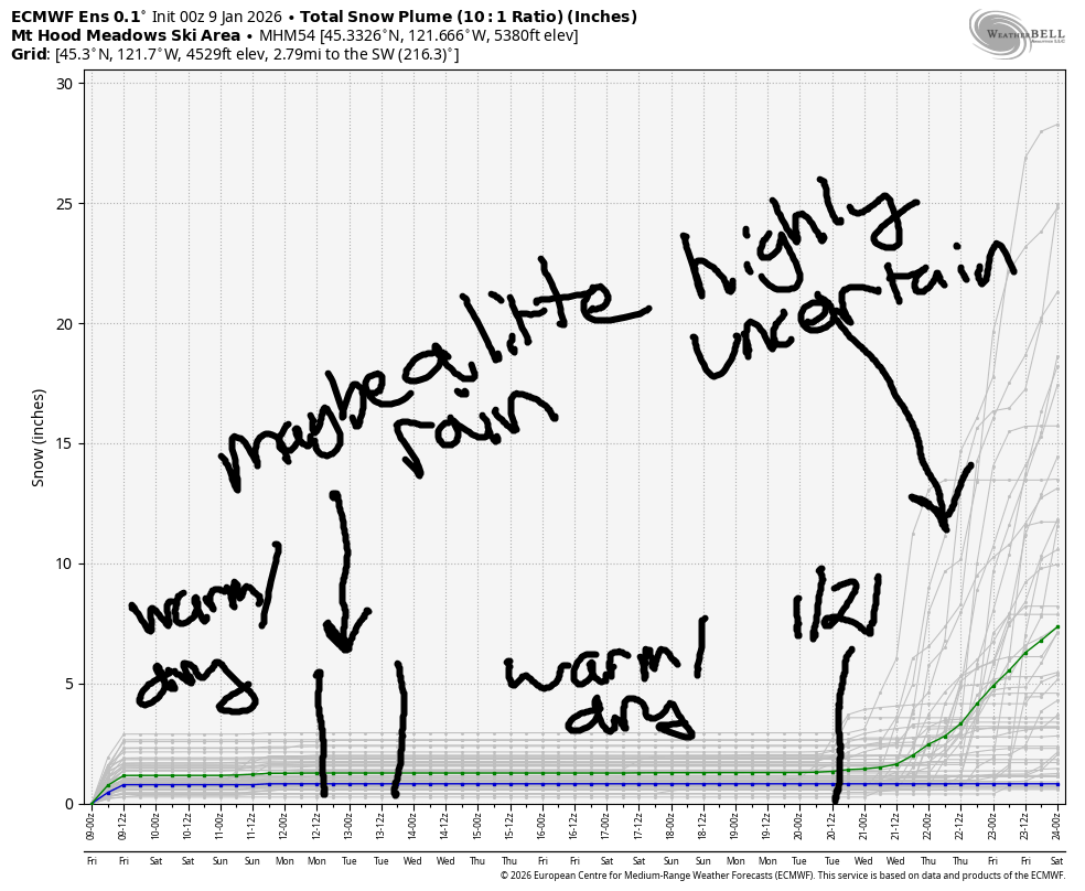
Hey skiers and snowboarders! Late forecast this morning – lots going on in my life, but not so much going on for the slopes today. Mt Hood picked up about three feet of new from this storm cycle, and that’s about all the snow we’ll get for a while. Other than a slight possibility of some light rain Tuesday(ish), there’s no precip in the forecast until the 20th of January at the earliest.
Short term Mt Hood snow forecast
Today (Friday) starts out cloudy on Mt Hood and ends partly high overcast. The free air freezing level (FAF) will be 2000′ this morning, 6000′ this afternoon, and 8500′ overnight. Temps rise from the upper 20s to mid 30s. Wind will be NW 10 in the morning, SW 10-15 this afternoon, and SW 20-30 overnight.
Saturday will be high overcast with the free air freezing level at 8500′ all day. Temps max out in the upper 30s to right around 40F. Wind: SW 15-30 all day depending on elevation. Sunday looks almost identical to Saturday, identical enough that I’ll say nothing more.
Extended Mt Hood Snow Forecast
Warmer weather is forecast on Monday – the FAF rises from 10,000′ in the morning to 12,000′ in the evening with temps at 5000′ rising to the upper 40s. Wind will be 25mph or less. Tuesday looks sunny, nearly 50F degrees, with light wind. Somewhere in there some ensemble members have a little rain, but that seems to be fading from the forecasts as we get closer.
Looking deeper into the future, we have warm, dry weather in the Mt Hood snow forecast until the 20th (ish) of the month. Good thing we just got a solid dump of snow. In case you were wondering, the Mt Hood snowpack currently sits at 41% of normal for this date….
Was that helpful? I knew it was! Guess what? All of this crucial work – from your personal wind and snow reports to the invaluable TATAS updates – is made possible by my relentless efforts. Maintaining this labor of love isn’t easy. Each daily forecast takes hours. Website hosting, weather model access, and back-end admin work takes time and money. That’s where you come in.
YOUR CONTRIBUTION MAKES A DIFFERENCE
- SUPPORT ACCURATE, HYPER-LOCAL WEATHER FORECASTING
- ENABLE ACCESS FOR ALL, EVEN THOSE WITH LESS MEANS
- SUPPORT A COOL HUMAN WHO WORKS HARD SO YOU CAN PLAY
Take a moment to click one of the buttons below. Donate $19.99 or more (how much does this forecast enhance your life?) and get the email in your inbox. Whether it’s a renewing subscription (auto-renew) or a one-time donation, every contribution makes a real difference. Help me keep this labor of love alive, so we can all continue playing, commuting, and living in the Gorge with peace of mind and the best weather forecasts possible. Thank you!


Hood River, Oregon 97031


GORGE WIND FORECAST
If you’re still seeing yesterday’s and it’s after 9am, try opening this in an incognito window
SHORT-TERM gorge wind forecast
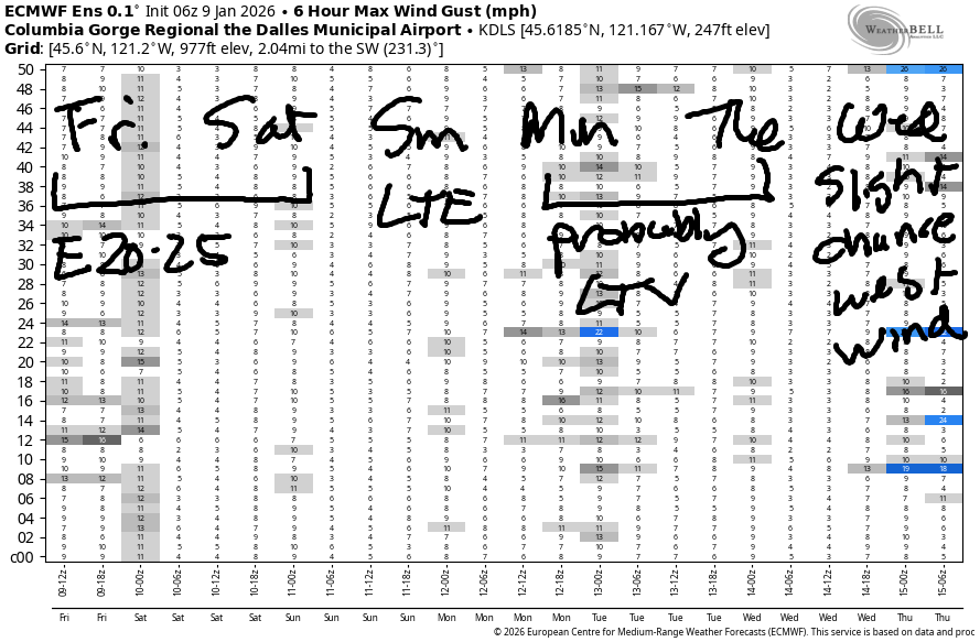
Hi friends! Not too much happening the next few days as high pressure settles in over the Pacific Northwest. We’ll have a couple days of marginal easterlies followed by too-light wind. Next chance for windsport wind is a low chance, but it’s a chance, and it’s next Wednesday.
Friday (TGIF) started with pressures of 30.48/30.46/30.44 for light onshore gradients. Wind on the river was variable to 10mph early this morning. By afternoon, easterlies return. We’ll have 20mph at Iwash (Rooster) Rock and Stevenson with 10-15mph at Home Valley and Viento. River flow over the last 24 hours was 174-204kcfs, river temp is 43.0F, and high temp forecast is 47F with decreasing clouds.
RIVER FLOW FOR SITES BETWEEN AVERY (EAST OF THE DALLES) AND RUFUS: CLICK HERE FOR JOHN DAY DAM FLOW.
RIVER FLOW FOR SITES BETWEEN STEVENSON AND DOUG’S BEACH (WEST OF THE DALLES): CLICK HERE FOR THE DALLES DAM FLOW

LONGER-TERM gorge wind forecast
Saturday starts with easterlies at 20-25mph at both Stevenson and Iwash. What wind there is fades quickly. By afternoon, we’ll have calm conditions all through the Gorge. High temp: 46F and partly cloudy. Sunday starts with very light east wind, picks up to 10mph near Stevenson, and drops back below 10mph in the afternoon. High temp: 49F and partly cloudy. Monday and Tuesday likely bring light/variable wind. Very strong high pressure is possible off the coast on Wednesday, which gives us a slight chance of Corridor westerlies. We’ll keep an eye on that for sure! Have a great day, everyone!
BARE BONES HOOD RIVER WEATHER FORECAST
Partly cloudy sky this morning. High clouds later. Temps start in the mid 30s and rise to the mid/upper 40s. Light westerlies early. Light easterlies later. No rainbows. Saturday will be mostly cloudy then partly cloudy. Temps start in the mid 30s and rise to the mid 40s. Light easterlies then dead calm. No rainbows. Sunday will be Nothing then partly cloudy. Temps start in the mid 30s and rise to the upper 40s. Light easterlies. No rainbows.
TEMIRA’S AWESOME TRAVEL ADVISORY SERVICE
HYPERLOCAL WEATHER FORECAST FOR THE COLUMBIA GORGE
THE DALLES, HOOD RIVER, WHITE SALMON, TROUT LAKE, STEVENSON, CASCADE LOCKS, PARKDALE, ODELL, HUSUM, BZ, MILL A, WILLARD, GOLDENDALE, RUFUS, ARLINGTON, boardman

Good morning, neighbors! It’s a cloudy start to Friday here in the Gorge, and I’m running very late today due to… other stuff! We have VERY boring weather coming up for the next couple of weeks – little to no precipitation with a big temperature inversion and intermittent clouds. At least this means TATAS gets to take some days off!
Glenwood this morning
Looking at Friday, Glenwood started at 35 degrees with clouds. Glenwood, you’re under-performing with the cold weather this winter, and you’re going to lose your right to daily admiration. Dufur, Parkdale, Middle Mountain, and Trout Lake are all colder. Those areas should be approached with caution due to the potential for icy roads. Speaking of… in an interesting twist, plate 829QNG (OR) that’s been associated with ¡CE and is now staying at Hampton Inn in Hood River is not currently an ¡CE vehicle. It is likely that this is a previous DHS rental now driven by someone with bad luck. Don’t freak out if you see this car out and about! Also, while Hampton does accept federal contracts, we don’t have confirmed reports of DHS agents staying at the hotel in Hood River.
Today’s Gorge weather forecast
On to the weather… high clouds all day to the west and clearing sky to the east. Temps max out in the upper 40s. Calm wind this morning picks up to E 20mph at Iwash (pen*s) Rock and Stevenson this afternoon. Saturday: mid 30s to start, mid 40s to finish with mid and high clouds. Wind will be E 20-25mph in the usual spots in the morning and calm in the afternoon. Sunday looks very similar to Saturday but with less wind. Same on Monday. Tuesday looks warmer and potentially sunny.
See: boring.
Speaking of boring, I think that’s enough writing for me today. I didn’t get enough sleep and am very tired and don’t feel creative. You go be creative today for me! Safe travels. -TATAS
HEY! DON’T STOP READING! Is this community-focused forecast helpful to you? It sure is! It takes me a couple hours a day to write. Please join your friends and neighbors in contributing to keep it going. Venmo: @thegorgeismygym PayPal: twomirrors@gmail.com USPS: Temira / PO Box 841 / Hood River, Oregon 97031 You can test out the forecast subscription for a few days for free by signing up below. Easy! Do it!
JONES BEACH, SAUVIE ISLAND, & COAST FORECAST
ON WINTER VACATION UNLESS DESPERATELY NEEDED.
