

MT HOOD SNOW FORECAST

Hey skiers and snowboarders! Excellent spring skiing is on tap today thanks to a hard freeze last night. Spring conditions linger into Saturday. By midday, Sunday, snowflakes will be flying. Sun returns Monday and sticks around Tuesday. Up next: models are coalescing around a significant snowstorm in the Wednesday-Thursday time period with somewhere in the neighborhood of 1-2 feet of snow with cool temps lingering into next weekend. After that: lots of uncertainty, but probably warm and dry.
Short term Mt Hood snow forecast
Friday will be sunny to start with a few clouds later. The free air freezing level rises from 8500′ to 10,000′ this afternoon before falling to 9000′ after midnight. Wind will be light and variable all day becoming W 10-15 overnight. Temps max out in the upper 40s at 5000′. Snow surface: frozen granular, hard n’ fast early, with corn snow later. Thank radiational cooling for that!
Saturday looks partly cloudy all day with increasing clouds overnight. The free air freezing level falls from 9000′ in the morning to 6000′ in the afternoon to 4000′ after midnight. Temps end up in the low-mid 30s at 5000′. Wind will be W 10-15 in the morning, W 20 in the afternoon, and WSW 15 overnight.
Extended Mt Hood Snow Forecast
Clouds Sunday morning quickly give way to light snowfall mid-morning. The snow level will be 4000′ in the morning, 3500′ in the afternoon, and 500-1000′ under clearing sky overnight. We’re expecting 0.1” water equivalent (WE) during the day for an inch of new. Overnight, double that is expected for a couple inches more. Wind will be WSW 10 in the morning, W 15-20 in the afternoon, and NW 30-35 overnight.
A few flurries early Monday quickly give way to clear sky. The free air freezing level starts around 1000′, rises to 2500′, and falls back to 1000′ overnight. No accumulating snow. Wind will be WN 30-35 early (could affect some lifts), WNW 10 in the afternoon (no problems there), and SE 15-20 after midnight. Temps max out in the upper 20s.
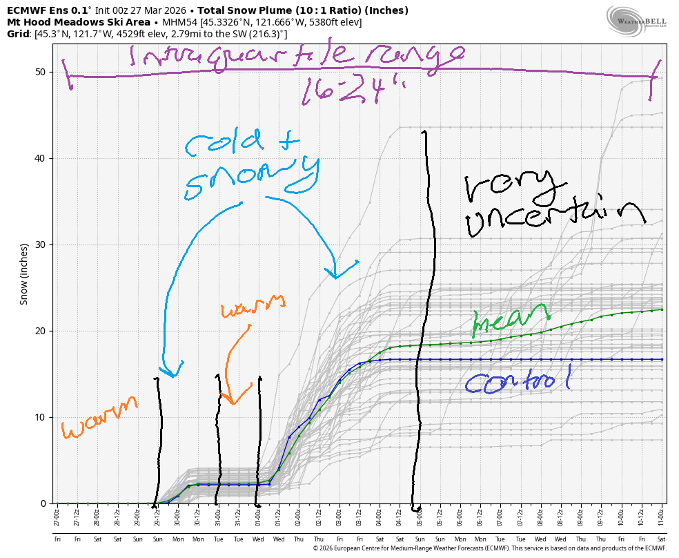
Dry, somewhat warmer weather is forecast for Tuesday. Starting Wednesday, colder, active, wet weather is forecast with significant snowfall for Mt. Hood. As of this morning, the Wednesday system looks to bring at least a foot of new snow to Mt. Hood. Cool temps persist into next weekend. The intraquartile range for snow through 4/11 is 16-24”. Hmmm…. I was going to take off my snow tires, but I might revisit that plan!
Was that helpful? I knew it was! Guess what? All of this crucial work – from your personal wind and snow reports to the invaluable TATAS updates – is made possible by my relentless efforts. Maintaining this labor of love isn’t easy. Each daily forecast takes hours. Website hosting, weather model access, and back-end admin work takes time and money. That’s where you come in.
YOUR CONTRIBUTION MAKES A DIFFERENCE
- SUPPORT ACCURATE, HYPER-LOCAL WEATHER FORECASTING
- ENABLE ACCESS FOR ALL, EVEN THOSE WITH LESS MEANS
- SUPPORT A COOL HUMAN WHO WORKS HARD SO YOU CAN PLAY
Take a moment to click one of the buttons below. Donate $19.99 or more (how much does this forecast enhance your life?) and get the email in your inbox. Whether it’s a renewing subscription (auto-renew) or a one-time donation, every contribution makes a real difference. Help me keep this labor of love alive, so we can all continue playing, commuting, and living in the Gorge with peace of mind and the best weather forecasts possible. Thank you!


Hood River, Oregon 97031


GORGE WIND FORECAST
If you’re still seeing yesterday’s and it’s after 9am, try opening this in an incognito window
SHORT-TERM gorge wind forecast
Hi friends! East wind is on tap today, and then we have a few days of westerlies. Very active weather next week gives us the possibility of strong westerlies out east here and there, but details are unclear at this time. The current remains quite high at Rufus – keep that in mind when planning.
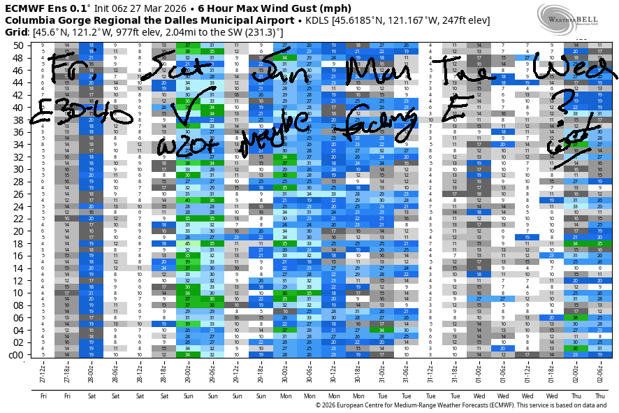
Looking at Friday morning… pressures started with 30.29/30.43/30.44, and easterlies were rocking. Iwash/Rooster started the day with 40mph, Stevenson with 30mph, and Viento with 20mph. The wind holds until late morning and then fades. By late afternoon, Iwash will be light/variable and Stevenson will be down to 10-15mph. River flow over the last 24 hours was 243-266kcfs, river temp is 46.6F, and high temp forecast is 61F with a few clouds moving in this afternoon.
RIVER FLOW FOR SITES BETWEEN AVERY (EAST OF THE DALLES) AND RUFUS: CLICK HERE FOR JOHN DAY DAM FLOW.
RIVER FLOW FOR SITES BETWEEN STEVENSON AND DOUG’S BEACH (WEST OF THE DALLES): CLICK HERE FOR THE DALLES DAM FLOW

LONGER-TERM gorge wind forecast
Westerlies return on Saturday. TJ’s Hatch dawn patrol could be as strong as 20-23mph. By the time the rest of us are ready, we’ll have 18-21mph from Viento to the Hatch with 11-14mph from Mosier to Doug’s. The wind holds through the morning. Afternoon sees the Hatch drop to gusty 16-19 while Stevenson to Mosier hangs in with gusty 19-22mph. Between Lyle and Arlington, afternoon westerlies rise to gusty 22-25mph. High temp: 61F with partly cloudy sky.
On Sunday, we start with light westerlies. A slow build is forecast – by midday, we’ll have 12-15mph from Stevenson to Arlington. Afternoon wind rises to gusty 18-21mph from Lyle to Arlington with 10-13mph and drizzle west of Lyle. High temp: 58F under mostly cloudy sky.
Stronger wind is possible overnight Sunday into Monday. As of this morning, the strongest wind coincides with darkness. Westerlies fade Monday afternoon as high pressure pushes inland. Easterlies are likely to return on Tuesday. More active weather returns on Wednesday with the possibility of intermittent periods of strong wind, but it’s far too early for precision forecasts. Hope to see you on the Nch’i Wana soon!

BARE BONES HOOD RIVER WEATHER FORECAST
Clear sky this morning. Partly cloudy later. Temps start near 30 and rise to the low 60s. Light easterlies. No rainbows. Saturday will be partly cloudy. Temps start in the upper 30s and rise to the low 60s. Moderate westerlies. No rainbows. Sunday will be drizzly. Temps start in the upper 30s and rise to the upper 50s. Light to moderate westerlies. 93% chance of rainbows.
TEMIRA’S AWESOME TRAVEL ADVISORY SERVICE
HYPERLOCAL WEATHER FORECAST FOR THE COLUMBIA GORGE
THE DALLES, HOOD RIVER, WHITE SALMON, TROUT LAKE, STEVENSON, CASCADE LOCKS, PARKDALE, ODELL, HUSUM, BZ, MILL A, WILLARD, GOLDENDALE, RUFUS, ARLINGTON, boardman
Good morning, neighbors! Frosty the frosty person is all over the Gorge this morning. It’s Friday, by the way, thank the stars. TATAS doesn’t get a day off this week, but maybe you do. In that case, TATAS is happy for you! Our plans for the weekend include dry, partly cloudy weather on Saturday followed by a little rain on Sunday. We’re back to sunshine (and frost) Monday, dry weather Tuesday, and then a potential downpour on Wednesday with cool weather next week.
Glenwood this morning
Friday started glorious but cold. Everyone in Glenwood was wandering around topless showing perky nipples this morning in 21 degrees. It was so cold in Glenwood, that perky nipples (of all genders) were visible through three layers of long undies and puffy coats. Elsewhere in the Gorge: 26-29 near Parkdale, 27-31 near the Dalles, 23F in Goldendale, and 21-25F in Trout Lake. Frost fans are doing their thing across the Hood River Valley as ahead-of-schedule and thus sensitive trees are crying for protection.
Those precocious trees will be helped by today’s weather: sunny early, partly cloudy later, and temps rising to 60-62F. That’s 6-9 degrees above normal. Today’s wind will be E 40mph early near Iwash (pen*s) Rock and 30mph near Stevenson. By this afternoon, the wind will be light enough to visit the naked beach at Iwash Rock. Stevenson retains easterlies at 10-15mph this afternoon.
Saturday’s Gorge weather forecast
Partly cloudy sky is forecast overnight. This leaves us less likely to experience frost on Saturday. Also in our favor: west wind. Parkdale: 32-35F Saturday morning. Near the Nch’i Wana, temps will be 37-42 to start Saturday. Early wind will be 15-20mph from Viento to Hood River with 10-15mph from Mosier to Murdoch. Afternoon wind rises to 15-20mph from Stevenson to Hood river with 20-25mph from Mosier to the Arlington Triangle. Temps climb to 61F (west), 64F (The Dalles) and 67F (The Desert). WARM!
All sorts of cool stuff is going on Saturday. It happens to be Minoru Yasui Day. Minoru Yasui fought for the rights of Japanese Americans in the 1940s. Remember, Japanese Americans were imprisoned in internment camps during WWII. Here in Hood River, many Japanese Americans had their farms stolen from them while they were imprisoned. I don’t have space for all the history, but you can read some and take part in the Saturday events to learn more.
Also Saturday: No Kings demonstrations all across the country and here in the Gorge. There’s an 11am march from the Hood River waterfront to downtown. There’s a 1:30pm protest on the 2nd street overpass. On Sunday, there’s a Palm Sunday Processional from Jackson Park to Mercado Guadalajara starting at 2pm, and there’s a demonstration in support of our immigrant neighbors at the Mercado at 3pm.
I hope to see you in the streets to support our immigrant neighbors, our rights, democracy, governmental checks and balances, and most importantly, care, friendliness, goodwill, and love to each other. Somehow this nation has normalized the cultivation and expression of hatred. It’s easy to fall in that trap – caring about others can feel painful and vulnerable – but there are other, more nurturing ways to be. Try it out and see for yourself!
Sunday’s Gorge weather forecast
On Sunday, we’ll have a cloudy day with some drizzle. After a 40ish degrees start along the river, temps rise to 58F-62F. At higher elevations, temps could drop to the mid 30s in the morning. Drizzle extends as far east as Hood River during the day and to Rowena overnight. Even South Wasco gets a trace of rain. Wind will be light westerly early and west 15mph in the afternoon. Much colder air moves in overnight.
Monday’s Gorge weather forecast
On Monday morning, we’re looking at clear sky and breezy conditions with the freezing level as low as 1000′. Wind-sheltered areas (Parkdale, Glenwood) are likely to see sub-freezing temps, and ditto for all areas above 1500′. Sunshine is forecast from sunrise to sunset – no clouds for you! Max temps will be 53-58F. Strong wind in the morning fades to 10-15mph in the afternoon.
Extended Gorge weather forecast
A dry, chilly morning is forecast Tuesday followed by a 55-59F east windy day. Much more interesting weather is forecast on Wednesday as models like the idea of a strong, wet system slamming into the Gorge like a dog with the zoomies accidentally running into your knees. Thanks to cooler temps aloft (for once in this not-winter-year), the mountains and passes will pick up significant snowfall Wednesday into Thursday. Yay. Beyond that… cool for a few days and probably warmer again starting next weekend. Safe travels. -TATAS
HEY! DON’T STOP READING! Is this community-focused forecast helpful to you? It sure is! It takes me a couple hours a day to write. Please join your friends and neighbors in contributing to keep it going. Venmo: @thegorgeismygym PayPal: twomirrors@gmail.com USPS: Temira / PO Box 841 / Hood River, Oregon 97031 You can test out the forecast subscription for a few days for free by signing up below. Easy! Do it!
JONES BEACH, SAUVIE ISLAND, & COAST FORECAST
ON WINTER VACATION UNLESS DESPERATELY NEEDED.

Leave a Reply