

MT HOOD SNOW FORECAST

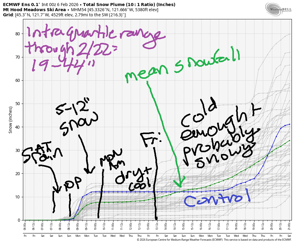
Hey skiers and snowboarders! Snow is in the forecast! There’s not a ton coming in this weekend – the intraquartile range through Monday is 5-12” – but it’s going to be enough to patch some things up at the resorts and keep things going. After a slate of dry, cool days next week, models promise significant snowfall starting late next week or next weekend. Fingers crossed! The intraquartile range through 2/22 is 19-44”. Vote for the high end of that!
Short term Mt Hood snow forecast
Friday will be far from snowy on Mt Hood. As a matter of fact, it’ll be the opposite: warm and sunny. The free air freezing level starts at 10,000′ and slowly falls to 7000′ after midnight. Temps at 5000′ max out in the mid to upper 40s. Wind will be light/variable early, W 15 in the afternoon, and SW 15-25 overnight. Bring some sunscreen!
Saturday starts off clear and quickly turns cloudy. Rain arrives mid-morning and sticks around through mid-evening, when rain switches to snow. The snow level will be 7000′ early, 6000′ in the afternoon, 5500′ at 10pm, and down to 4000′ after midnight. About an inch of rain is forecast prior to the switch, after which we’ll see around 0.6” water equivalent of very wet snow. Call it 3-4” new overnight as temps at 5000′ hover right around 32F. Wind will be SW 15-25 in the morning, W 30 in the afternoon, W 20 in the evening, and light/variable after midnight.
Extended Mt Hood Snow Forecast
Sunday will be snowy, but the amount of snow we get really depends on exactly where a band of moisture associated with the cold front and a moderate atmospheric river sets up. As I said previously, total snowfall for the weekend is 5-12” in the IQ range, but the deterministic GFS is WAY more optimistic. It’s possible we could get lucky. Either way, expect a snowy Sunday with the snow level falling from 4000′ in the morning to 2000′ in the afternoon. Temps at 5000′ will hover near 32F most of the day and will drop to the upper 20s in the afternoon. Wind will be light and variable most of the day, and it’ll rise to WNW 30-35 after midnight.
Light snow Monday morning gives way to clear sky in the afternoon. The snow level will be around 3000′. Just a couple inches of snow are forecast prior to the sun coming out. Wind will be WNW 30-35 in the morning, light SW in the afternoon, and SE 10-20 overnight. Several days of dry, cool weather are forecast next week. That’s followed by a shift to cool, snowy weather next weekend. Keep your fingers crossed for that. Both the GFS and the ECMWF insist on temps staying below freezing at 5000′ for that extended forecast period. Yay. Snow!
Was that helpful? I knew it was! Guess what? All of this crucial work – from your personal wind and snow reports to the invaluable TATAS updates – is made possible by my relentless efforts. Maintaining this labor of love isn’t easy. Each daily forecast takes hours. Website hosting, weather model access, and back-end admin work takes time and money. That’s where you come in.
YOUR CONTRIBUTION MAKES A DIFFERENCE
- SUPPORT ACCURATE, HYPER-LOCAL WEATHER FORECASTING
- ENABLE ACCESS FOR ALL, EVEN THOSE WITH LESS MEANS
- SUPPORT A COOL HUMAN WHO WORKS HARD SO YOU CAN PLAY
Take a moment to click one of the buttons below. Donate $19.99 or more (how much does this forecast enhance your life?) and get the email in your inbox. Whether it’s a renewing subscription (auto-renew) or a one-time donation, every contribution makes a real difference. Help me keep this labor of love alive, so we can all continue playing, commuting, and living in the Gorge with peace of mind and the best weather forecasts possible. Thank you!


Hood River, Oregon 97031


GORGE WIND FORECAST
If you’re still seeing yesterday’s and it’s after 9am, try opening this in an incognito window
SHORT-TERM gorge wind forecast
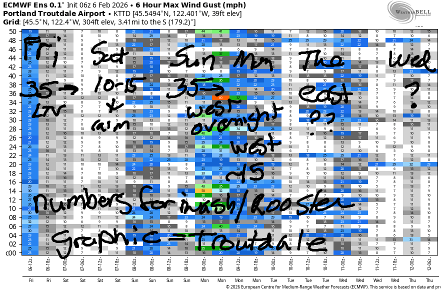
Hi friends! Not much going on in the next few days. In a fun twist, we’ll see the wind briefly switch to westerly late Sunday into Monday, but the strongest wind looks to arrive after dark. A more active weather pattern sets up over the next couple of weeks, which likely leaves us with less consistent wind than we’ve seen in recent weeks.
Friday started with pressures of 30.11/30.23 for 0.12 offshore. Easterlies prior to dawn were 35mph at Iwash, 21mph at Stevenson, and 18mph at Viento. If you want it, get on it as early as you can. By midday, the wind drops to 10-15mph, and in the afternoon, it turns light easterly or light/variable. River flow over the last 24 hours was 157-189kcfs, river temp is 40.8F, and high temp forecast is 53F with sun in the windy zones and maybe widespread sun everywhere in the afternoon.
RIVER FLOW FOR SITES BETWEEN AVERY (EAST OF THE DALLES) AND RUFUS: CLICK HERE FOR JOHN DAY DAM FLOW.
RIVER FLOW FOR SITES BETWEEN STEVENSON AND DOUG’S BEACH (WEST OF THE DALLES): CLICK HERE FOR THE DALLES DAM FLOW

LONGER-TERM gorge wind forecast
Saturday starts with E 10-15mph at Iwash/Rooster and Stevenson. The wind turns calm midday and shifts to very light westerlies west of Hood River after 1pm. High temp: low 50s, cloudy, and rainy. Sunday starts with light/variable wind and picks up to E 25-35 for a few hours midday. Overnight, the wind turns westerly. High temp: upper 40s to low 50s with rain.
Monday sees light west wind. It’s possible we could see 17-20mph east of The Dalles, but 14-17mph is more likely. High temp: 50ish. Easterlies are likely to return on Tuesday and may be strong enough to get you on the river. Beyond that: not much to talk about. Stay warm and safe out there and keep an eye on everyone else who’s playing in the chilly river!
BARE BONES HOOD RIVER WEATHER FORECAST
Nothing this morning. Mostly clear this afternoon. Temps start in the low 40s and rise to the low 50s. Light easterlies early. Calm later. No rainbows. Saturday will be cloudy with rain after 1pm. Temps start in the upper 30s and rise to the low 50s. Calm wind most of the day. Light westerlies in the afternoon. 11% chance of rainbows. Sunday will be rainy. Temps start in the mid 40s and rise to the upper 40s. Light easterlies all day. West wind after 4pm. 84% chance of rainbows.
TEMIRA’S AWESOME TRAVEL ADVISORY SERVICE
HYPERLOCAL WEATHER FORECAST FOR THE COLUMBIA GORGE
THE DALLES, HOOD RIVER, WHITE SALMON, TROUT LAKE, STEVENSON, CASCADE LOCKS, PARKDALE, ODELL, HUSUM, BZ, MILL A, WILLARD, GOLDENDALE, RUFUS, ARLINGTON, boardman

Good morning, neighbors! Not much going on in the weather today: Nothing this morning with sun to the west followed by a chance of sun for all this afternoon. Rain, glorious rain, arrives mid-morning on Saturday and sticks around on and off through the weekend. Models are still working out the details of Sunday’s rain, but they are convinced that it will be snow up in the mountains. Finally, some snow! If we get really, really lucky, the snow level will drop to 2000′ on Monday night and give a few folks in the Gorge a few snowflakes.
Glenwood this morning and today’s gorge weather forecast
Looking around the Gorge this morning, we have 38F in Glenwood and nobody below freezing. To the west, where it’s windy: sunshine. Everywhere else: Nothing. Models insist the Nothing will burn off this afternoon everywhere west of The Dalles and will at least partially dissipate everywhere. PLEASE LET IT BE TRUE! Temps rise to the mid-upper 40s today with some low 50s possible if the sun comes out. Morning easterlies will be 35mph near Iwash (the lack of body-cams isn’t the problem – normalization of violence and lack of respect for the Constitution is the problem) Rock and 20mph near Stevenson. By afternoon, the wind will be blessedly light and variable for all.
Want to do something political today? Jeff Merkley is there for you with three Oregon town halls: 11am at the Mt Hood Town Hall, 1pm at Mid-Columbia Senior Center in The Dalles, and 6pm at Clackamas High School. This will not impact the weather one bit, but it may impact what happens with the !CE-y road situation. No !CE on the roads this morning as far as I know.
Saturday’s Gorge weather forecast
Nothing reforms tonight and is joined by its family: low clouds, mid clouds, and high clouds. This leaves us all near 40F in the morning. By mid-morning, rain arrives for areas west of Hood River. In the evening, drizzle is likely all the way out to Hermiston and also in south Wasco and Sherman Counties. High temps on Saturday are forecast to be in the low-mid 50s, but that seems unlikely without the influence of west wind. Wind will be light/variable all day east of Cascade Locks, but it will become light westerly west of Viento in the afternoon, which could lead to temps rising to the low-mid 50s. Elsewhere: mid to upper 40s. Commuters: rain will be heavy west of Viento form 1pm on into early evening.
Sunday’s Gorge weather forecast
Wet weather continues Sunday as a cold front with an atmospheric river tap lingers somewhere near the Gorge. Models aren’t certain where it will set up, and 50-100miles north, south, or other-dimensional will make a huge difference on how much rain we get and how much snow Mt. Hood and Mt. Adams receive. We’ll have to wait and see. Plan on a wet day for cheering on the Seahawks in the Super Bowl. GO HAWKS!
Extended Gorge weather forecast
Lingering showers Monday morning give way to (probably) dry weather for much of next week. Let’s leave it there for now – I need to get going to the mountain because I’m going to scream if I spend another day stuck under the Nothing. Sunshine, here I come! Safe travels. -TATAS
HEY! DON’T STOP READING! Is this community-focused forecast helpful to you? It sure is! It takes me a couple hours a day to write. Please join your friends and neighbors in contributing to keep it going. Venmo: @thegorgeismygym PayPal: twomirrors@gmail.com USPS: Temira / PO Box 841 / Hood River, Oregon 97031 You can test out the forecast subscription for a few days for free by signing up below. Easy! Do it!
JONES BEACH, SAUVIE ISLAND, & COAST FORECAST
ON WINTER VACATION UNLESS DESPERATELY NEEDED.
