

MT HOOD SNOW FORECAST

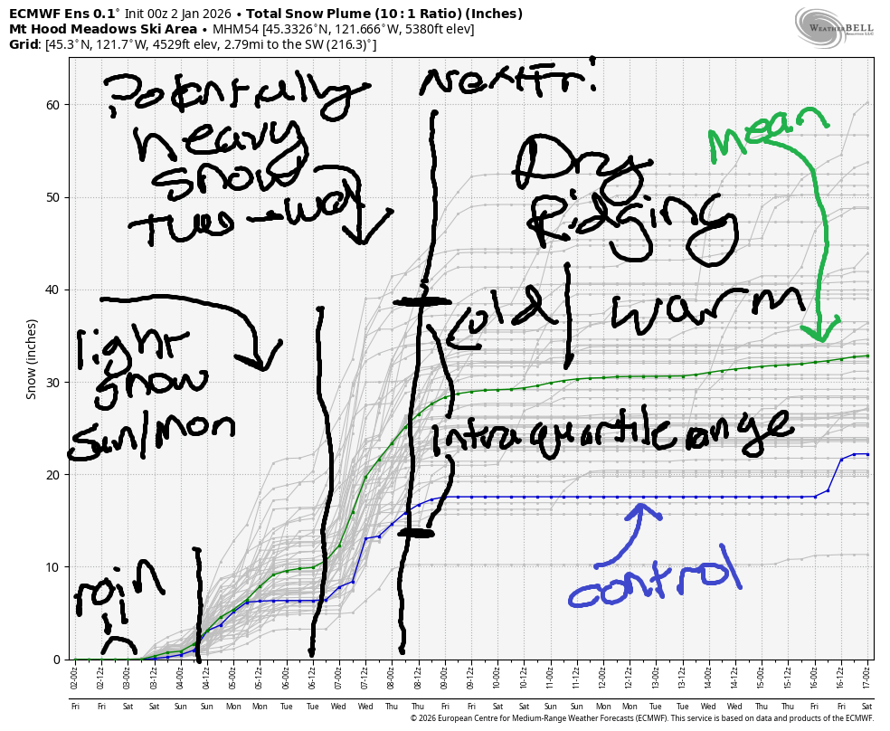
Hey skiers and snowboarders! The next couple of days on Mt Hood look less-than-ideal thanks to r**n, but there’s hope in the forecast next week. Colder weather and potentially significant snowfall is in the cards starting Tuesday. Intraquartile range for snowfall through next Friday (when the weather likely turns dry again) is 22-33”, down from yesterday, but still a worthy amount and enough to keep the resorts ticking along. But not today… Meadows chose to suspend ops for today due to the saturated snowpack. Timberline is suspending night ops until more snow falls. Summit Pass: open. Skibowl: not open. Teacup: not grooming today due to the saturated snowpack. Temps drop Sunday, and we’ll pick up snow again starting then. In the meantime…
Short term Mt Hood snow forecast
We’re expecting rain on Mt Hood on Friday. The snow level hovers around 6500′ all day. We’ll see about 0.2” rain during the day and another 0.1” to 0.2” overnight with temps at 5000′ near 40F. Wind will be WSW 25-35 in the morning, SSW 10-15 in the afternoon, and SW 20-35 overnight.
Saturday sees light drizzle in the morning and mixed precip overnight. The snow level will be 6000′-6500′ during the day and 5000-5500′ after midnight. We’ll see about 0.2” rain during the day. Overnight, we’re expecting about 0.3” mixed precip for maybe an inch of wet snow at 5000′ and a couple inches up high. Wind: SW 20-35 early, SW 25-40 midday, S 10-20 in the afternoon, and WSW 50-60 overnight.
Extended Mt Hood Snow Forecast
Sunday starts with light snowfall, turns partly cloudy, and returns to snowfall overnight. The snow level will be 5000′ early, 3500′ in the afternoon, and 2500′ after midnight. Temps fall from 34F to 28F at 5000′ over the 24 hour period. About 0.2” water equivalent (WE) is forecast in the morning for 2” snow. Another 0.2” WE is forecast overnight for 2-3” more. Wind: WSW 50-60 early, WSW 25-30 mid-morning, SW 10-20 in the afternoon, and W/WSW 25 from the evening on into Monday morning.
A trace of snow is forecast Monday, but otherwise, the sky will be clear for much of the day. The snow level will be 2500′ in the morning, 2000′ in the afternoon, and 500′ after midnight. Wind: WSW 20-25 in the morning, WNW 15-20 in the afternoon, and W 15 overnight. Tuesday starts dry and then turns snowy. Snowfall persists into Wednesday. It’s unclear how much snow we’ll see in that 24 hour period. We have a 70-80% chance of 6” or more and 20-50% chance of 12” or more. Of course we should all cross our fingers for the 12”+ scenario! Beyond that, models indicate additional snowfall through next Friday(ish), when we (probably) enter another dry/warm period. Keep doing your snow dances, people. See you on the snow soon!
Was that helpful? I knew it was! Guess what? All of this crucial work – from your personal wind and snow reports to the invaluable TATAS updates – is made possible by my relentless efforts. Maintaining this labor of love isn’t easy. Each daily forecast takes hours. Website hosting, weather model access, and back-end admin work takes time and money. That’s where you come in.
YOUR CONTRIBUTION MAKES A DIFFERENCE
- SUPPORT ACCURATE, HYPER-LOCAL WEATHER FORECASTING
- ENABLE ACCESS FOR ALL, EVEN THOSE WITH LESS MEANS
- SUPPORT A COOL HUMAN WHO WORKS HARD SO YOU CAN PLAY
Take a moment to click one of the buttons below. Donate $19.99 or more (how much does this forecast enhance your life?) and get the email in your inbox. Whether it’s a renewing subscription (auto-renew) or a one-time donation, every contribution makes a real difference. Help me keep this labor of love alive, so we can all continue playing, commuting, and living in the Gorge with peace of mind and the best weather forecasts possible. Thank you!


Hood River, Oregon 97031


GORGE WIND FORECAST
If you’re still seeing yesterday’s and it’s after 9am, try opening this in an incognito window
SHORT-TERM gorge wind forecast
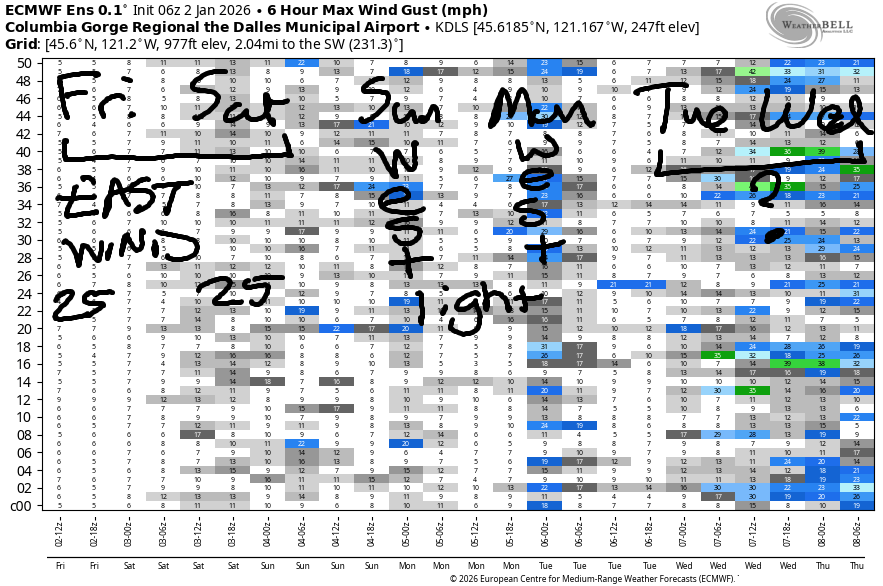
Hi friends! Easterlies are forecast the next couple of days, and then we’ll have a day or maybe more of light westerlies. I don’t think we’ll see strong enough west wind to get you on the river.
Friday morning started off with these pressures: 29.85/29.93/29.94 with offshore gradients and east wind. We’ll see 20-25mph all day at Iwash and 15-20mph at Stevenson with 15mph or less at Viento. Wind increases around 10pm for a few hours, but we’ll all be sleeping then! River flow over the last 24 hours was 174-206kcfs, river temp is 43.9F, and high temp forecast is 45F with rain in the morning and cloudy weather later.
RIVER FLOW FOR SITES BETWEEN AVERY (EAST OF THE DALLES) AND RUFUS: CLICK HERE FOR JOHN DAY DAM FLOW.
RIVER FLOW FOR SITES BETWEEN STEVENSON AND DOUG’S BEACH (WEST OF THE DALLES): CLICK HERE FOR THE DALLES DAM FLOW

LONGER-TERM gorge wind forecast
Saturday starts with east wind at 25mph at both Stevenson and Iwash (Rooster) Rock. The wind bounces around a bit at Iwash and finishes up at 25-30mph there. Stevenson holds at 25mph all day. High temp: 46F with rain early and dry, cloudy weather most of the day.
A low pressure system swings in on Sunday, but it’s not looking like it’ll be the west wind you were looking for. The day starts with W 20-30 near Iwash rock and 10-13mph near Stevenson. 10-13mph west wind fills in from Stevenson to Rufus midday before dropping below 10mph in the afternoon. We could see a short period of 18-22mph westerlies near Arlington mid-morning, but those too will fade to nearly-nothing in the afternoon. High temp: 48F with rain in the morning and dry weather in the afternoon. Light onshore flow continues on Monday and potentially on Tuesday, but there’s no clear sign of a windsport west wind day in the next week or so. Enjoy the week, everyone!
BARE BONES HOOD RIVER WEATHER FORECAST
Cloudy all day with rain in the morning. Temps start in the mid 30s and rise to the mid 40s. Light easterlies. 1.5% chance of rainbows. Saturday will be rainy early and dry from midday on. Temps start in the upper 30s and rise to the mid 40s. Light easterlies. 1.5% chance of rainbows. Sunday will be drizzly in the morning and rainy overnight with a break in the middle. Temps start in the upper 30s and rise to the upper 40s. Light westerlies. 97.3% chance of rainbows.
TEMIRA’S AWESOME TRAVEL ADVISORY SERVICE
HYPERLOCAL WEATHER FORECAST FOR THE COLUMBIA GORGE
THE DALLES, HOOD RIVER, WHITE SALMON, TROUT LAKE, STEVENSON, CASCADE LOCKS, PARKDALE, ODELL, HUSUM, BZ, MILL A, WILLARD, GOLDENDALE, RUFUS, ARLINGTON, boardman
Good morning, neighbors! Cold, ucky weather continues today. “Ucky” is an official weather term meaning “gloomy, cold, and shitty.” Some of us are still sub-freezing with icy roads and accumulating freezing rain. The rest of us: ucky, with dark, drab, gray sky, fog for some, and drizzle for others. Other road news: no signs of ¡CE-Y roads today but I’m not sure anyone’s been out playing hide n’ seek yet.
Sub-freezing temps should go the way of the dodo this afternoon, which leaves us set for an intermittently drizzly weekend. Colder weather is forecast starting Monday and especially Tuesday, when we could see the snow level fall as low as 500-1000′ for a period of time. While a widespread massive snowstorm isn’t likely, our elevated communities may experience their first significant snowstorm of the season Tuesday afternoon into Wednesday.
Before we get into that, let’s get into Glenwood this Friday morning. It’s 32 degrees there, right on the edge for icy roads. Everyone sharpened their skates yesterday in hope of some road ice hockey, but it’s just not cold enough or icy enough. Next time! Elsewhere: freezing drizzle is continuing this morning for the upper parts of Parkdale. While the drizzle is confined to the west, other areas are sub-freezing and likely to be slick: Goldendale, Dufur, Japanese Hollow, Trout Lake, Wasco. Temps warm up today and are unlikely to drop below freezing again tonight.
Rest of today’s weather: drizzle as far east as Mosier through 10am with moderate to heavy rain near Cascade Locks in that same time frame. Rain tapers off midday. South Wasco and The Dalles-Biggs see another round of drizzle early evening. Today’s high temps will be in the mid 40s to the west, low 40s near The Dalles, and upper 30s out in the desert. Wind: easterly at 20-25mph near Iwash (it’s not a Rooster) Rock and Stevenson.
Saturday starts off with a round of moderately heavy rain between 1am and 4am, but hopefully you’ll be sleeping and won’t have to drive in it, because that rain extends all the way from Troutdale to Arlington and then eventually to the Tri-Cities prior to sunrise. Rest of the day: mostly dry from 10am to 4pm but also mostly cloudy. Morning temps will be in the upper 30s. Afternoon: mid 40s. Snow level: 5500-6000′. Thanks to a low pressure system off the coast, east wind will be 25mph near both Iwash (still not a rooster) Rock and Stevenson.
Cloudy, drizzly weather continues Sunday with high temps in the upper 40s. Monday: Cloudy to start, sunny to finish with icy roads likely in the morning and overnight. Tuesday starts dry. Thanks to cold air aloft and potentially heavy precipitation in the afternoon, we could see the snow level fall to 500-1000′. Uncertainty is still high about the details of this system, so I’m not going to pin us down to any specifics yet. One thing is for sure: we’ll see significant snowfall on the mountain passes Tuesday into Wednesday. Not so ideal for commuters, but definitely good news for skiers and people who work at ski resorts. Safe travels. -TATAS
HEY! DON’T STOP READING! Is this community-focused forecast helpful to you? It sure is! It takes me a couple hours a day to write. Please join your friends and neighbors in contributing to keep it going. Venmo: @thegorgeismygym PayPal: twomirrors@gmail.com USPS: Temira / PO Box 841 / Hood River, Oregon 97031 You can test out the forecast subscription for a few days for free by signing up below. Easy! Do it!
JONES BEACH, SAUVIE ISLAND, & COAST FORECAST
ON WINTER VACATION UNLESS DESPERATELY NEEDED.
