MT. HOOD SNOW FORECAST

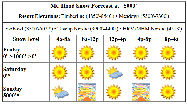
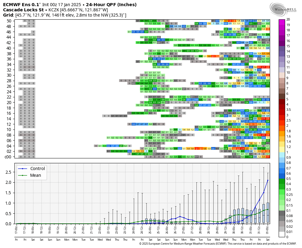
Hey skiers and snowboarders! We’re sticking with sunshine on the slopes for the long term. By “long term”, I mean most of the time between now and next weekend. A few members of the GFS think the mountain could pick up a little snow (an inch, maybe) on Tuesday, but the vast majority of the ensemble members keep things dry through the end of the week. Sub-freezing temps persist through Sunday (mostly), and then slope-side temps rise above freezing to start next week. Snow surface: frozen granular with loose granular atop in some areas. With cold temps, things are likely to get scoured rather than to soften to corn. Sunday looks warmer with warming more likley than today and tomorrow.
Friday kicks off clear and cold with temps in the teens on the slopes. Slather on sunscreen and head for the hills. The free air freezing level will be around 1000′ all day with temps rising to the mid 20s under sunny sky. Wind: N 10 in the morning becoming NE 10 in the afternoon and NE 15 after midnight.
Liking this forecast?
Sunny weather is in the cards for Saturday morning. That’s followed by some high clouds in the afternoon and clear sky overnight. Temps remain sub-freezing all day with teens in the morning and upper 20s in the afternoon. Wind: NE 15 in the morning, variable to 10 in the afternoon, and NW 15-20 after midnight. Sunday starts with a few clouds and turns clear. The free air freezing level hovers around 5000′ with temps in the upper 20s to low 30s all day. Wind: NW 15-20 in the morning, NE 10-15 in the afternoon, and light/variable overnight.
Warmer sunny weather is forecast on Monday as warm air on the west side briefly wins the battle with east side cold. The free air freezing level will be in the 8000′-10,000′ range with temps rising to the mid 30s at 5000′. Note that an inversion will be in place, so the lower elevations (Skibowl, Teacup) could be colder. Cooler air returns on Tuesday as a (probably) dry system swings through from the NW. This one will be a repeat of yesterday’s, meaning despite the dry, sunny weather, wind could affect lifts. We continue with dry weather at least through Thursday. Models have hints of precip next weekend, but the ensembles are far from unanimous. Better signs of a return to snowy weather are seen after next weekend. In the meantime, you’ve got sun and snow. Get some!
Was that helpful? I knew it was! Guess what? All of this crucial work – from your personal wind and snow reports to the invaluable TATAS updates – is made possible by my relentless efforts. Maintaining this labor of love isn’t easy. Each daily forecast takes hours. Website hosting, weather model access, and back-end admin work takes time and money. That’s where you come in.
YOUR CONTRIBUTION MAKES A DIFFERENCE
- SUPPORT ACCURATE, HYPER-LOCAL WEATHER FORECASTING
- ENABLE ACCESS FOR ALL, EVEN THOSE WITH LESS MEANS
- SUPPORT A COOL HUMAN WHO WORKS HARD SO YOU CAN PLAY
Take a moment to click one of the buttons below. Donate $19.99 or more (how much does this forecast enhance your life?) and get the email in your inbox. Whether it’s a renewing subscription (auto-renew) or a one-time donation, every contribution makes a real difference. Help me keep this labor of love alive, so we can all continue playing, commuting, and living in the Gorge with peace of mind and the best weather forecasts possible. Thank you!


Hood River, Oregon 97031


GORGE WIND FORECAST

Hi friends! Nice to see you at the Hatch yesterday. What a looker of a day it was – sunny, steady westerlies, and clouds in the hole. After a brief bit of west wind early today, we’re back to easterlies for the long haul. Exception: Tuesday afternoon. Friday kicks off with lingering onshore pressures of 30.37/30.30 for 0.07 gradient. Models insist we’ll switch to east wind today as inland high pressure strengthens with the assistance of cold air from Alberta. Wind speeds switch from W 5ish, maybe 5-10ish, to E 15ish at both Iwash (Rooster) Rock and Stevenson this afternoon. River flow over the last 24 hours was 89-161kcfs, river temp is 42.62F (and it felt like it yesterday – brr), and high temp forecast is 45F and mostly sunny.
Easterlies kick back in on Saturday as cold, high-pressure air makes itself at home on the east side of the Cascades. The day starts with 40mph at Iwash and 25mph at Stevenson. Stevenson briefly rises to 30mph midday before dropping back to 25mph. Iwash drops to 35mph in the afternoon. High temp: 43F with plenty of sunshine. Sunday starts with E 15 at Stevenson and E 25 at Iwash. Stevenson builds to 25mph in the afternoon, and Iwash rises to 35mph. High temp: 40F and sunny. Cold, dry air makes a name for itself on Monday by firing up an even windier day: 50mph at Iwash and 35mph at Stevenson. A weak system on Tuesday could set off some afternoon westerlies before we’re back to east wind Wednesday (not that strong) and Thursday (potentially quite strong). This pattern (maybe) starts to break down next weekend. Between now and then, enjoy those windy days!
BARE BONES HOOD RIVER WEATHER FORECAST
Partly Nothing this morning and mostly clear later. Temps start in the mid 30s and rise to the mid 40s. Light westerlies early. Basically calm later. No rainbows. Saturday starts partly Nothing with high clouds and turns partly cloudy then clear. Temps start in the low 30s and rise to the low 40s. Easterlies. No rainbows. Sunday starts partly Nothing and turns clear. Temps start in the mid 20s and rise to 40 or so. Light easterlies. No rainbows.
TEMIRA’S AWESOME TRAVEL ADVISORY SERVICE (DETAILED FORECAST FOR THE COLUMBIA GORGE)

Good morning, neighbors! “Dry” is a good word to describe the weather around here all the way through next week. Next chance of wet weather comes Friday, but models aren’t unanimous on that. Stronger hints of a pattern change (from striped to paisley) are seen in the last few days of this month. In a fun twist, thanks to cold, dry continental air, Nothing (that cloud that hovers in the lowlands on inversion days) will be less persistent than of late. In other words, you’ll see some sun despite the inverted temps.
Before we dive in, let’s start our day with some Glenwood: 20 degrees, dewpoint 16.
So, yesterday’s system opened the door for a tap into colder Canadian air. Peak Canadian happens on Monday. Please switch your beer to Molson, your hoofed ruminant ungulate to moose, and your beanie to a toque. Between now and Monday, for the most part, here’s the pattern: partial Nothing in the morning, clear sky in the afternoon, and east wind. Overnight temps fall into the teens and 20s above the Nothing thanks to clear sky and increasingly dry air. Daytime highs in the lowlands rise to 40 or so each day. Coldest night will be Sunday.
Easterlies do this: 10-15mph today; 35-40 at Iwash and 25-30 at Stevenson tomorrow; 25-35 at Iwash Sunday with 15-25 at Stevenson. Monday: 50mph at Iwash and 35mph at Stevenson.
Models hint at a boring, dry system (like yesterday’s) swinging through on Tuesday and briefly returning clouds and west wind to the west side. Colder air surges back in, briefly, after that. About 60% of the models have some precipitation in the Friday-Saturday time frame. That’s followed by (probably) dry weather to start next week and then (probably) a return to colder, wetter weather. That said, there’s plenty of variety in the models starting late next week, so any forecast beyond that should be taken with a grain of kosher salt. To celebrate the cease-fire, which I hope we’re all doing together. Safe travels. -TATAS
HEY! DON’T STOP READING! Is this community-focused forecast helpful to you? It sure it! It takes me a couple hours a day to write. Please jump in a contribute to keep it going. Venmo: @thegorgeismygym PayPal: twomirrors@gmail.com USPS: Temira / PO Box 841 / Hood River, Oregon 97031 You can test out the forecast subscription for a few days for free by clicking this link: https://subscribepage.io/YhevGc


