

GORGE WIND FORECAST
today’s gorge wind forecast
Hi friends! If your body is feeling a bit tired and sore, today’s the rest day you’ve been waiting for. Unless you’re Walker, in which case it’ll be plenty windy, and your body, being young, will be just fine with another day on the river! Stronger wind is forecast Saturday through Sunday for sure and potentially Monday through Wednesday as well, although model uncertainty ramps up starting early next week. Between Saturday and Sunday, it’s a tough call – they both have things going for them. Saturday’s late session could be absolutely spectacular, but Sunday’s strong wind should be around for more of the day.
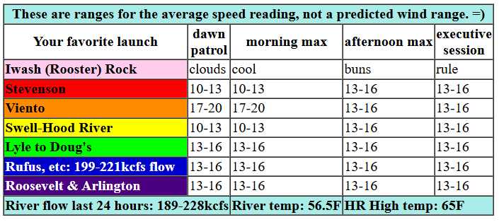
Let’s dive in to our Friday forecast. 6am pressures weren’t bad at all: 30.13/30.07/30.03 for gradients of 0.06 and 0.04. Models suggest 13-16ish today from Viento to Arlington this morning and Stevenson to Rufus this afternoon. If I had to guess, I’d guess we’ll be on the low end of that. River flow over the last 24 hours was 189-228kcfs (199-221kcfs at Rufus), river temp is 56.5F, and high temp forecast is 65F.

tomorrow’s gorge wind forecast
Saturday morning brings light westerlies and showers and hopefully lots of friends visiting from Canada! Early afternoon brings instability and a slight chance of thunder. From mid-afternoon on, high pressure builds offshore, stability arrives, upper flow rises to NW 35, and we’re left with a very good setup. Dawn Patrol will be under 10mph. We’ll see a slow build into the early afternoon, when Stevenson-Hood River rise to 15-18 and Mosier to Arlington climb to 22-25. After that, the good setup arrives (hopefully on time!). Stevenson-Hood River builds to very gusty 20-24. Mosier to Rufus aims for 28-32. Philippi to Threemile jump to 23-26. After 5pm, Lyle-Arlington should be at 28-32 with a shot at 31-34 from Maryhill to Arlington. High temp: 65F for Hood River and 67F for Arlington.
extended Gorge wind forecast
Instability disappears on Sunday, but so does our strong offshore high pressure. Even so, we’ll have a nice thermal and synoptic-scale gradient thanks to a deep low in the Rockies. Dawn Patrol kicks off cloudy with gusty 14-17 from Stevenson to Hood River. Mosier-Threemile opens the day at 25-28. By midday, westerlies rise to gusty 21-24 from Stevenson to Hood River, 28-32 from Mosier to Arlington, and 25-28 at Threemile. 30-35 is possible in the afternoon between Lyle and Arlington. High temp: 61F for Hood River and 63F for Arlington.
We then move on to Victoria Day (welcome, Canadians – I’ve got your back!). It appears we’ll have a light start in the morning and mid to upper 20s east of Hood River in the afternoon. Models keep bring the west wind (probably – there’s a fair bit of range) in the low to mid 20s Tuesday and Wednesday. That’s good for now, I think. See you on the Nch’i Wana!
Was that helpful? I knew it was! Guess what? All of this crucial work – from your personal wind and snow reports to the invaluable TATAS updates – is made possible by my relentless efforts. Maintaining this labor of love isn’t easy. Each daily forecast takes hours. Website hosting, weather model access, and back-end admin work takes time and money. That’s where you come in.
YOUR CONTRIBUTION MAKES A DIFFERENCE
- SUPPORT ACCURATE, HYPER-LOCAL WEATHER FORECASTING
- ENABLE ACCESS FOR ALL, EVEN THOSE WITH LESS MEANS
- SUPPORT A COOL HUMAN WHO WORKS HARD SO YOU CAN PLAY
Take a moment to click one of the buttons below. Donate $19.99 or more (how much does this forecast enhance your life?) and get the email in your inbox. Whether it’s a renewing subscription (auto-renew) or a one-time donation, every contribution makes a real difference. Help me keep this labor of love alive, so we can all continue playing, commuting, and living in the Gorge with peace of mind and the best weather forecasts possible. Thank you!


Hood River, Oregon 97031


JONES BEACH, SAUVIE ISLAND, & COAST FORECAST
Wind northerly unless otherwise indicated. For coast, it’s North/Central/South with the “central” at approximately Florence. Swell forecast from NWS for central coast. Jones: westerly unless otherwise stated. Sauvie Island: northerly unless otherwise stated. Friday: SW15/LTW/N15-20, W swell 7′ at 12 seconds. Saturday: NW15/NW15/N20, W 6′ @ 11. Sunday: LTW?LTW/N20, NW 7′ @ 9. Jones Friday: LTV. Saturday: 12-15. Sunday: LTW. Sauvie Island Friday: LTV. Saturday: NW 16-19. Sunday: Variable to 13.
BARE BONES HOOD RIVER WEATHER FORECAST
Cloudy sky this morning turns partly cloudy. Temps start near 50 and rise to the mid 60s. Light to moderate westerlies. No rainbows. Saturday will be showery in the morning and partly cloudy in the afternoon. Temps start in the upper 40s and rise to the mid 60s. Light west wind early. Moderately strong later. 96% chance of rainbows. Sunday will be partly cloudy with intermittent sprinkles in the morning. Temps start in the mid 40s and rise to the low 60s. Moderately strong westerlies. 97% chance of rainbows.
TEMIRA’S AWESOME TRAVEL ADVISORY SERVICE – FRIDAY 5/16
HYPERLOCAL WEATHER FORECAST FOR THE COLUMBIA GORGE
THE DALLES, HOOD RIVER, WHITE SALMON, TROUT LAKE, STEVENSON, CASCADE LOCKS, PARKDALE, ODELL, HUSUM, BZ, MILL A, WILLARD, GOLDENDALE, RUFUS, ARLINGTON, boardman
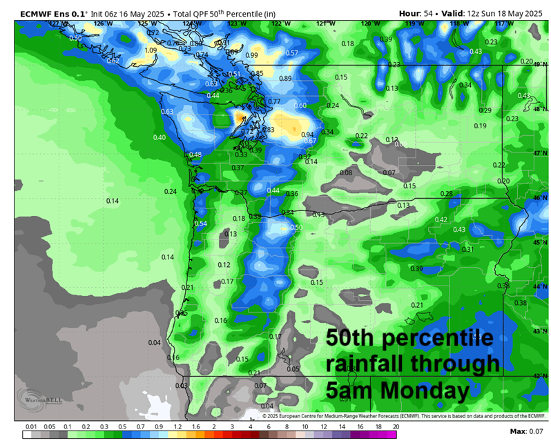
Good morning, neighbors! Perfectly reasonable weather continues until at least the 25th, and models are pretty certain that reasonable weather will continue beyond that. While this doesn’t support my attempt at growing a state record watermelon (232lbs), it makes me happy that spring isn’t behaving like summer. Best chance of rain in the next ten days comes on Saturday, when the 50th percentile Euro ensemble gives us 0.3” to 0.4” for the Cascades and wettest parts of the Gorge with a trace to 0.1” east of Hood River. Not much, but not nothing. Celebrate damp time, c’mon!
Glenwood this morning, and the Gorge weather forecast for today
Friday looks cool and cloudy in the west and sunny to the east to start. Our friends in Glenwood were above freezing this morning with a low temp of 35F. Temps rise to the mid 60s today, and high clouds increase in the afternoon. For once, westerlies won’t be blasting. They’ll merely be breezing: 10-15mph all day between Stevenson and the Arlington Triangle. Is “breezing” a word? I dunno. But it is now.
Saturday’s Gorge weather forecast
On Saturday, Johnnies will be Johnnying (also a questionable word) as breezing becomes blasting in the afternoon. We’ll have a mostly cloudy start all the way through the Gorge with temps in the upper 40s. Showers and sprinkles extend all the way to the Arlington Triangle in the morning and linger around Cascade Locks into late afternoon. We can’t rule out a thunderstorm or two or at least randomly scattered downpours as 850mb temps fall to 2C in the afternoon. Temps max out in the mid 60s. While the wind will be light, less than 10mph, in the morning, it won’t be in the afternoon. Areas west of Mosier rise to 20-25mph in the afternoon, and areas between Mosier and Threemile Canyon rise to 25-35mph. Up in the hills: also windy as 850mb wind rises to NW 25mph late in the day.
sunday’s gorge weather forecast
Partly cloudy, windy weather is planned for Sunday all through the entire Scenic Area and beyond into the eastern desert where the Bighorn Sheep walk along I-84 hitching rides to somewhere with less wind and fewer fences. Westerlies will be 20-25mph west of Mosier and 25-35mph to the east. Strong wind aloft should keep most places frost free, but with 850mb temps at -2 to -3C Sunday morning, Glenwood could see frost as could some of the coldest parts of the Upper Hood River Valley. Sunday’s high temps: low 60s with plenty of sunbreaks.
extended gorge weather forecast
Similar temps and similarly partly cloudy weather linger through the middle of next week. Least windy time period: Monday morning, so pencil in some spraying if it’s time to spray things. Models hint at a slow climb in temps as we move towards the weekend after Victoria Day weekend, but models also increase the uncertainty. Monday the 26th is my favorite of all: the high temp spread for that day is 61-89 degrees. And this is why we can’t trust our phones that far out – they just give a number, not this nearly 30 degree prediction of uncertainty. Between now and then, excellent weather for running loads of manure to the garden. Yeah, I’m obsessed. Happy planting. Safe travels. -TATAS
HEY! DON’T STOP READING! Is this community-focused forecast helpful to you? It sure is! It takes me a couple hours a day to write. Please join your friends and neighbors in contributing to keep it going. Venmo: @thegorgeismygym PayPal: twomirrors@gmail.com USPS: Temira / PO Box 841 / Hood River, Oregon 97031 You can test out the forecast subscription for a few days for free by signing up below. Easy! Do it!
