

GORGE WIND FORECAST
today’s gorge wind forecast
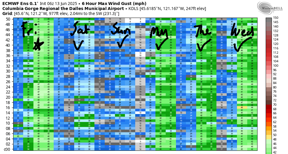
Hi friends! It’s Friday (TGIF!), and another day of strong wind is on tap. Models continue the wind through the weekend – mid 20s on Saturday and low 20s on Sunday – before ramping it back up again next week. If current matters to you, know that the current was way down during the day yesterday. No promises that it’ll stay down, but it was a nice respite.
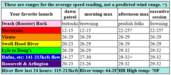
So, Friday… TJ’s Dawn Patrol started with pressures of 30.09/29.97/29.89 for gradients of 0.12 and 0.08. Wind was in the mid teens at Stevenson, 17-20 at the Hatch, and 18-22 pretty much everywhere else. Marine clouds were stacked up all the way to the west side of Underwood Mountain, and they’re forecast to only partially break up in Stevenson today as a trough of cold air moves inland. This looks good! Expect westerlies to build to 25-28 from Viento to Mosier this morning with 22-25 from Lyle to Rufus. Rowena remains closed due to the Rowena Fire. Afternoon wind holds at 26-29 from Viento to Hood River with 28-32 from Mosier to Arlington. Stevenson’s a big question mark today thanks to the clouds. If they burn off, it’ll climb to the mid 20s. If not, expect gusty less-than-20 mph today. River flow over the last 24 hours was 115-213kcfs (141-213kcfs at Rufus, which was epic for paddling yesterday), river temp is 64.2F, and high temp forecast is 70F for Hood River and 76F for Arlington.
One caveat to today: sometimes when troughs move inland, they can break the cap and result in the wind becoming gusty and lesser than forecast. Working against this outcome today is the solid marine layer in the west. If I had to guess, I’d guess the west side wind wind will be more stable than wind east of the Cascades, but that’s a hypothesis. There will be plenty of wind today somewhere for you, broken cap or stable situation. One other thing… the trough is likely to nudge the clouds east a bit this morning. That could result in the Hatch droppping before surging when the clouds burn off.

tomorrow’s gorge wind forecast
Lesser marine clouds are forecast for Saturday, but westerlies continue. TJ’s Dawn Patrol looks like 22-25 from Viento to Mosier with clouds and 14-17 at Stevenson and sunshine and 14-17 east of Mosier to Arlington. Mid-morning wind rises to 22-25 from Viento to Mosier. Afternoon: gusty 19-22 from Stevenson to Hood River, 22-25 from Mosier to Avery, and 13-16 east to Arlington. High temp: 76F for Hood River and 79F at Arlington.
extended Gorge wind forecast
Moving on to Sunday… a somewhat warmer, somewhat less breezy day is on tap. Opening shot is 20-23 from Swell to Mosier with 14-17 at Stevenson and less than 10mph east of Mosier. With warm temps forecast for the metro area and not-much-warmer temps forecast for the desert, the wind will drop to 19-22 mid-morning. It holds in the afternoon and spreads all the way from Stevenson to Doug’s at 19-22mph. East of there: less than 15mph. High temp: 82F for Hood River and 83F for Arlington.
An approaching trough of cool air on Monday combines with warmer air in the desert for upper 20s out east. Mid-20s are forecast on Tuesday, probably focused on the eastern Gorge. Another strong west wind day is in the ensemble predictions for Wednesday, and westerlies are forecast to continue all the way through next weekend. It’s unlikely to be quite as strong as this week’s wind (we’ll be lacking the offshore high), but it still looks like a long-and-strong stretch of westerlies. No rest days in sight unless you make them yourself. Have a great day on the Nch’i Wana. See you out there!
Was that helpful? I knew it was! Guess what? All of this crucial work – from your personal wind and snow reports to the invaluable TATAS updates – is made possible by my relentless efforts. Maintaining this labor of love isn’t easy. Each daily forecast takes hours. Website hosting, weather model access, and back-end admin work takes time and money. That’s where you come in.
YOUR CONTRIBUTION MAKES A DIFFERENCE
- SUPPORT ACCURATE, HYPER-LOCAL WEATHER FORECASTING
- ENABLE ACCESS FOR ALL, EVEN THOSE WITH LESS MEANS
- SUPPORT A COOL HUMAN WHO WORKS HARD SO YOU CAN PLAY
Take a moment to click one of the buttons below. Donate $19.99 or more (how much does this forecast enhance your life?) and get the email in your inbox. Whether it’s a renewing subscription (auto-renew) or a one-time donation, every contribution makes a real difference. Help me keep this labor of love alive, so we can all continue playing, commuting, and living in the Gorge with peace of mind and the best weather forecasts possible. Thank you!


Hood River, Oregon 97031


JONES BEACH, SAUVIE ISLAND, & COAST FORECAST
Wind northerly unless otherwise indicated. For coast, it’s North/Central/South with the “central” at approximately Florence. Swell forecast from NWS for central coast. Jones: westerly unless otherwise stated. Sauvie Island: northerly unless otherwise stated. Friday: 10-15/10-15/30-35, NW swell 5′ at 8 seconds and SW 2′ at 14 seconds. Saturday: 15-20/20/30-35, NW 5′ @ 8. Sunday: 20/20/25-30, NW 5′ @ 8. Jones Friday: 15-18. Saturday: 17-20. Sunday: 22-25. Sauvie Island Friday: 11-14. Saturday: 15-18 > 5pm. Sunday: 15-18.
BARE BONES HOOD RIVER WEATHER FORECAST
Clear sky this morning stays that way. temps start in the low 50s and rise to 70. Strong westerlies. No rainbows. Saturday will be mostly clear then clear. Temps start in the mid 40s and rise to the mi d70s. Moderately strong westerlies. No rainbows. Sunday will be partly cloudy then clear. Temps start near 50 and rise to the low 80s. Moderate westerlies. No rainbows.
TEMIRA’S AWESOME TRAVEL ADVISORY SERVICE – FRIDAY 6/13
HYPERLOCAL WEATHER FORECAST FOR THE COLUMBIA GORGE
THE DALLES, HOOD RIVER, WHITE SALMON, TROUT LAKE, STEVENSON, CASCADE LOCKS, PARKDALE, ODELL, HUSUM, BZ, MILL A, WILLARD, GOLDENDALE, RUFUS, ARLINGTON, boardman
Good morning, neighbors! As best I can tell, we did good yesterday and had no new fires. If you drove past Rowena yesterday, you saw a sobering sight. I did, and my heart goes out to all the folks who lost homes and pets and everything they own. There is a community meeting tonight at 7pm at The Dalles High School auditorium where fire teams and local agencies will provide an update on the fire. If you can’t attend, the meeting will be posted on Facebook and YouTube.
Sometimes it’s helpful to do something in the face of tragedy. Fro some people, it’s helpful to attend a rally. If that’s you, read this paragraph. If not, skip tot he next one. If you’d like to support democracy, full federal funding of USFS and associated fire fighters, separation of powers, and welcoming communities where folks of all backgrounds feel safe and can be themselves… attend the rallies on Saturday at noon: Stevenson at the courthouse, Hood River at 2nd and State, Bingen at Daubenspeck Park, and The Dalles at a location you’ll need to sign up to learn about.
GLENWOOD’S MORNING AND TODAY’S GORGE WEATHER FORECAST
Before we dive into the weather, let’s check in with our friends in Glenwood: it was 38 DEGREES there this morning. Good job, Glenwood! You froze your butt off. The rest of us started somewhere close to 50 degrees. High temps rise to 70 (west), 76 (The Dalles), and low 80s (out in the watermelon-growing zone near Hermiston). We’ll have west wind at 20-25mph west of Lyle this morning with 20mph east to Arlington. Afternoon wind climbs to 25-30mph west of The Dalles and 30-35mph from The Dalles to the Arlington Triangle. Those of you west of Underwood will have clouds this morning and partly cloudy sky this afternoon. The rest of us start clear and add a few scattered mid-level clouds as a weak weather system pushes inland from the ocean, gets annoyed at the lack of ocean below it, and responds by making a few clouds in the sky. That’s a pretty innocuous response to frustration, and one we can all learn from. Sorry I ended that sentence in a preposition.
SATURDAY’S GORGE WEATHER FORECAST
Saturday morning starts chilly thanks to that weather system I mentioned; it’s a cool one. Expect mid-40s to start for most places under mostly clear sky. Exception: areas from Stevenson westward might start with some low clouds. After that chilly start, terms rise to the mid 70s (west), upper 70s (east), and mid 80s (watermelon zone). Westerlies? Yes. 20-25mph west of Lyle to start with 25mph or so all the way from Stevenson o The Dalles in the afternoon with 20mph near Rufus and 15mph near the Arlington Triangle. This is just enough wind to get the tumbleweeds moving. Strangely, despite being out in the desert quite a bit lately, I’ve seen no tumbleweeds. Perhaps they’ve moved to Canada?
EXTENDED GORGE WEATHER FORECAST
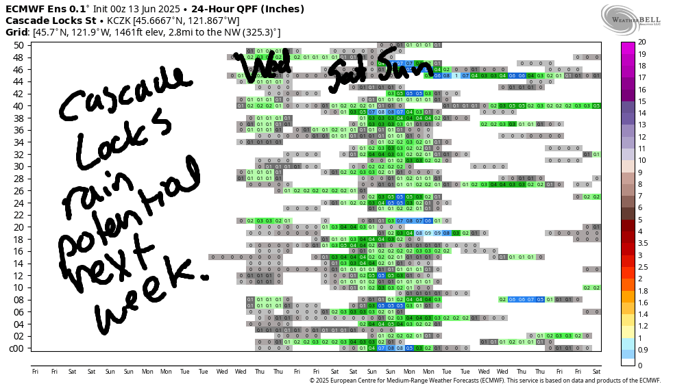
On Sunday, we’ll have warmer temps: low 80s most places under clear sky. Strip off the pants, ditch the long sleeves, and take advantage of flexible rules about nudity in Oregon and Washington. Show off your Arlington Triangle, and go Full Bush With No Bikini! Westerlies will be around 20mph all day west of The Dalles and less than 15mph east of The Dalles. Cooler, breezier weather is forecast starting Monday and continuing all the way through next week, when high temps will stay below 80. It’s possible we’ll see a few sprinkles (less than 0.10”) on Tuesday(ish). There’s a better chance for rain next weekend – we’ll be keeping a very close eye on that for our cherry farmer friends. Until then… safe travels. -TATAS
HEY! DON’T STOP READING! Is this community-focused forecast helpful to you? It sure is! It takes me a couple hours a day to write. Please join your friends and neighbors in contributing to keep it going. Venmo: @thegorgeismygym PayPal: twomirrors@gmail.com USPS: Temira / PO Box 841 / Hood River, Oregon 97031 You can test out the forecast subscription for a few days for free by signing up below. Easy! Do it!

One response to “Friday Gorge wind forecast: windy. TATAS weather: cool and breezy with a chance of rain next weekend.”
Hi Temira, It’s been a couple weeks since I used PayPal to donate. I answered your “request” for my email address soon after, but wondering if posts will be emailed soon. I don’t think I’ve ever had any issues with delivery of 1st time “new” addresses coming through. Thanks Roni