

GORGE WIND FORECAST
If you’re still seeing yesterday’s and it’s after 9am, try opening this in an incognito window
today’s gorge wind forecast
Hi friends! Yesterday was another fun one on the Columbia. Today’s going to be lighter, and then we’re right back into windy weather for the weekend and potentially beyond. There’s some uncertainty in the early part of next week thanks to the potential for hot weather, but as of now, ensembles are leaning towards hot-and-windy rather than hot-and-calm. Let’s take a closer look at the next week or so in the Gorge wind forecast, shall we?
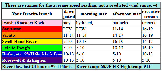
Today is Friday (TGIF), and it started with under 10mph everywhere except Viento. There, the iWind/iKite sensor was reading 14mph. Pressures at 6am were 30.16/30.11/30.10 for gradients of 0.05 and 0.01. What you see is what you get this morning. We’ll be waiting until late afternoon, when the metro area starts to cool and the desert really heats up, for more wind. Around 5pm, and into the evening, we should see 14-17 from Stevenson to Hood River with 16-19 from Mosier to Doug’s. River flow over the last 24 hours was 97-116kcfs (98-116kcfs at Rufus), river temp is 68.9F, and high temp forecast is 91F for Hood River with clear sky.
RIVER FLOW FOR SITES BETWEEN AVERY (EAST OF THE DALLES) AND RUFUS: CLICK HERE FOR JOHN DAY DAM FLOW.
RIVER FLOW FOR SITES BETWEEN STEVENSON AND DOUG’S BEACH (WEST OF THE DALLES): CLICK HERE FOR THE DALLES DAM FLOW

tomorrow’s gorge wind forecast
A surprising amount of uncertainty exists in Saturday’s forecast. The Euro model hints at a few marine clouds pushing inland west of Hood River, and they also hint at those marine clouds deepening for a few hours in the morning. If that scenario plays out, we’ll beat the models. The Euro and GFS have vastly different ideas of Saturday’s wind speed. From the GFS, we have 17-20 from Stevenson to Doug’s with a dip midday. Looking at the Euro ensembles, we have 20-23 or a bit more. Either way, we’re looking at a high temp if 91F with clear sky. I’m leaning towards the stronger wind based on the possibility of morning cloud support combined with very strong offshore high pressure.
extended Gorge wind forecast
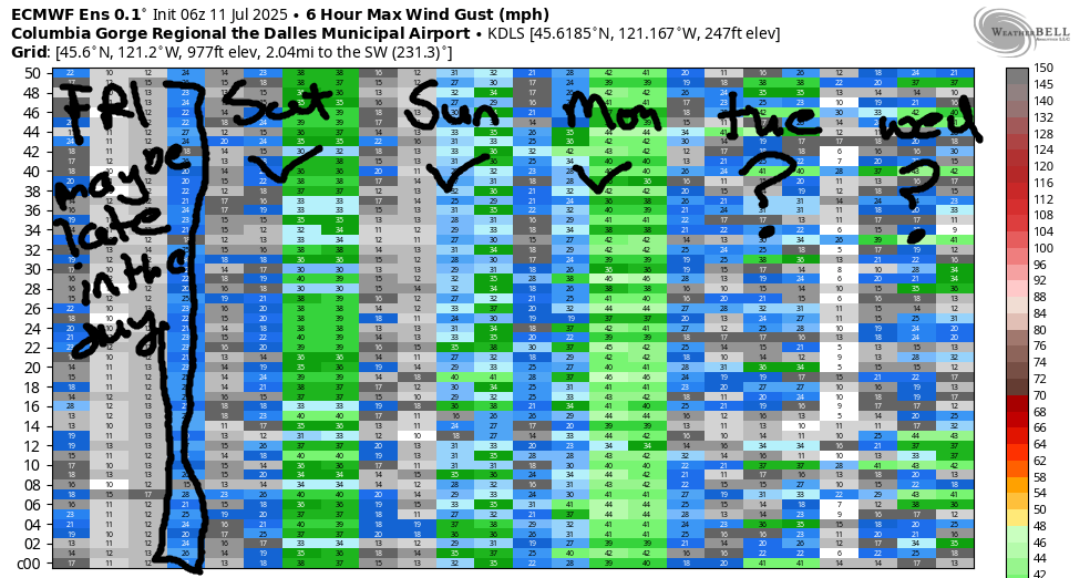
Moving on to Sunday… a little less uncertainty is present, but there’s still a surprising bit for a short-term forecast. Models suggest a light start followed by a slow and steady build to 20-23 between Stevenson and Doug’s. There’s a hint of Avery and Rufus in the evening. High temps range from the mid 90s in Hood River to the upper 90s and low triple digits out near Rufus and Arlington.
A drop in temps on Monday sets us up for a windier day. The GFS isn’t all that excited about the wind, but the overall setup sure looks good: strong offshore high pressure, hot weather in the desert, and marine cloud potential for the western Gorge. Ensembles agree with the overall setup and are calling for 26-29ish, while the GFS is only calling for 20-23ish. Way too much uncertainty is present on Tuesday and Wednesday to even attempt a forecast, but generally speaking, most of the ensembles are hinting at west wind. Models hint at some sort of cooldown in the Thursday-Friday time frame. That sets us up for yet another round of westerlies. Let’s leave it here for now today. Stay cool. I’ll see you on the Nch’i Wana!
Was that helpful? I knew it was! Guess what? All of this crucial work – from your personal wind and snow reports to the invaluable TATAS updates – is made possible by my relentless efforts. Maintaining this labor of love isn’t easy. Each daily forecast takes hours. Website hosting, weather model access, and back-end admin work takes time and money. That’s where you come in.
YOUR CONTRIBUTION MAKES A DIFFERENCE
- SUPPORT ACCURATE, HYPER-LOCAL WEATHER FORECASTING
- ENABLE ACCESS FOR ALL, EVEN THOSE WITH LESS MEANS
- SUPPORT A COOL HUMAN WHO WORKS HARD SO YOU CAN PLAY
Take a moment to click one of the buttons below. Donate $19.99 or more (how much does this forecast enhance your life?) and get the email in your inbox. Whether it’s a renewing subscription (auto-renew) or a one-time donation, every contribution makes a real difference. Help me keep this labor of love alive, so we can all continue playing, commuting, and living in the Gorge with peace of mind and the best weather forecasts possible. Thank you!


Hood River, Oregon 97031


JONES BEACH, SAUVIE ISLAND, & COAST FORECAST
Wind northerly unless otherwise indicated. For coast, it’s North/Central/South with the “central” at approximately Florence. Swell forecast from NWS for central coast. Jones: westerly unless otherwise stated. Sauvie Island: northerly unless otherwise stated. Coast Friday: 20-25/20/30-40, NW swell 5′ at 9 seconds. Saturday: 20-25/25/30-40, NW 7′ @ 11. Sunday: 20-25/25-30/30-35, NW 7′ @ 10. Jones Friday: 20-23. Saturday: 19-22. Sunday: 22-25. Sauvie Friday: 15-18. Saturday: 14-17. Sunday: 20-23.
BARE BONES HOOD RIVER WEATHER FORECAST
Clear all day. Temps start in the low 60s and rise to the low 90s. Light westerlies most of the day. Moderate westerlies late. No rainbows. Saturday will be clear. Temps start in the low 60s and rise to the low 90s. Moderate westerlies. No rainbows. Sunday will be sunny. Temps start in the mid 60s and rise to the mid 90s. Light westerlies early. Moderate later. No rainbows.
TEMIRA’S AWESOME TRAVEL ADVISORY SERVICE
HYPERLOCAL WEATHER FORECAST FOR THE COLUMBIA GORGE
THE DALLES, HOOD RIVER, WHITE SALMON, TROUT LAKE, STEVENSON, CASCADE LOCKS, PARKDALE, ODELL, HUSUM, BZ, MILL A, WILLARD, GOLDENDALE, RUFUS, ARLINGTON, boardman
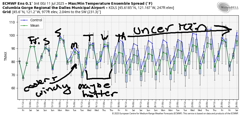
Good morning, neighbors! Rather warm weather, 90+ degrees, continues through next Wednesday with a little dip in temps on Monday. NWS has issued an extreme heat watch for next Tuesday and Wednesday, but as of now, there’s no clear sign of temps being 100+ degrees those day – just our standard-variety 90-something days. Starting next Thursday, there’s as much uncertainty in the forecast as there is for the forces of kindness in this world. You cannot resolve the uncertainty in the forecast. However, you can help change the world by refusing to engage in acts of ill will, cruelty, or divisiveness.
glenwood’s dirty bird morning
Nothing divisive is happening in Glenwood this morning where it was 48 degrees to start the day. Everyone there is tickling their toucan this morning. That, I’ve been told, is NOT a euphemism for a sexual act, but I think I may have been lied to. For the rest of the day, everyone in Glenwood will be flicking their Flicker, goosing their Grosbeak, and caressing their Crow. All of this while listening to the songs of the Western Meadowlark. FYI, I’m listening to a recording of that bird as I write this.
today’s gorge weather
Weather for Friday starts with a few little fluffy clouds overhead. Those burn off and leave us with clear sky. After a 60ish degree start for most of us, temps rise to 90+ for all of us: 91 to the west and 96 to the east. Westerlies will be under 10mph most of the day. They’ll rise to 15-20mph between Stevenson and Murdoch this afternoon. This sounds like perfect weather for rearranging Atlantic Giant vines – they get floppy (like a soft p*nis) in the heat and don’t break when you yank on them.
Clear sky sticks around tonight. I was thinking it’d be a nice night to watch for meteors, but there aren’t any meteor showers tonight. You’ll have to settle for stargazing. A great book for that, and a kid-friendly one, is H. A. Rey’s “Find The Constellations”.
saturday’s gorge weather forecast
Saturday looks sunny, hot, and muggy. The dewpoint rises to 54-57 degrees all through the Gorge and stays there. Blech. Temps max out around 90 (west), 97 (Murdoch), and 99 (out where the watermelons grow). It’ll be windy, but the strength and location really depends on how many marine clouds make it how far into the Gorge for how long. Call it 15-20mph or more all day long at least as far east as Rowena.
extended gorge weather forecast
Mostly clear sky sticks around Sunday, and temps climb a few more degrees. After a hot and muggy start (mid 60s, probably), temps climb to 94 (west), 99 (The Dalles), and 103 (melon-growing zone). Wind will be light to start the day, but it’ll climb to 20mph in the afternoon between Stevenson and The Dalles. High temps fall 5-10 degrees on Monday, which leaves us sunny, warm, and windy.
For Tuesday and Wednesday, NWS has issued an Extreme Heat Watch. As we do all summer, we’ll be watching for extreme heat. We’re just making it explicit this time, and because it’s explicit, you’re welcome to use any four-letter words you like! While there’s some risk of very warm temps, the Euro ensemble currently has The Dalles at 95-100 both days, which isn’t all that extreme for The Dalles and is nowhere near the record high for those two days. July 15th’s record high is 108. July 16th’s record high is 115. Both of those records were set in 1941, and neither of those records is likely to fall. This record-gazing got me curious about the last day where the record is 100+. That’s September 13th with a record of 100 set in 1922. Okay, that’s enough for today. Safe travels. -TATAS
HEY! DON’T STOP READING! Is this community-focused forecast helpful to you? It sure is! It takes me a couple hours a day to write. Please join your friends and neighbors in contributing to keep it going. Venmo: @thegorgeismygym PayPal: twomirrors@gmail.com USPS: Temira / PO Box 841 / Hood River, Oregon 97031 You can test out the forecast subscription for a few days for free by signing up below. Easy! Do it!
