

GORGE WIND FORECAST
today’s gorge wind forecast
Hi friends! Today’s looking like an excellent day for rest (or mountain biking or gravel biking in the shade). Get yourself ready for Saturday, which is going to be a nuker, probably best east of Mosier. Sunday’s Gorge wind forecast is all over the place with models predicting anything from “not much” to “pretty strong”. That said, the general setup is good for over-performing westerlies. Synoptic-scale conditions (big picture) look good through at least the middle of next week. Now, before I forget, if you (I think your name may be Jim) lost a windsurf board on I-84 yesterday, I have it. Please reach out! If I don’t hear from you by the end of the weekend, I’ll hand it over to the Hood River County Sheriff’s office, but for now, the ODOT guy I talked to and I agreed that I’m probably the most likely person to be able to find you and get it back to you ASAP.
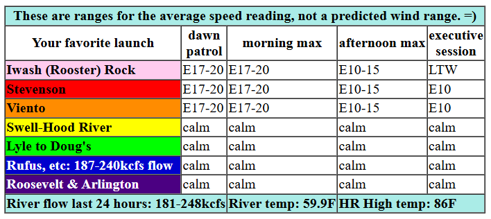
Okay. Friday’s forecast. Not much to see here. Inland ridging started the day, and inland ridging shall finish the day. Hotter temps are forecast for the Valley of Willies (Willamette Valley) than the desert, and that will keep the wind easterly (and marginal) today. We started with pressures of 30.23/30.22/30.24 for nearly flat gradients and light/variable wind. Easterlies pick up to 15-20mph near Stevenson, Viento, and Iwash (Rooster) Rock for a few hours this morning before dropping to 10-15mph this afternoon. Iwash turns light westerly (less than 10mph) this evening. River flow over the last 24 hours was 181-248kcfs, river temp is 59.9F, and high temp forecast is 86F for Hood River.

tomorrow’s gorge wind forecast
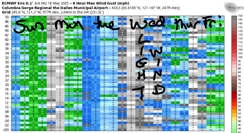
Strong high pressure builds offshore on Saturday as a weak trough moves inland. Cool air pours into the west side all day from the NW, and upper-level wind rises to NW 30mph. The only catch is that this approaching trough may push clouds past Hood River mid-morning, which would knock down the wind west of Mosier (or west of the cloud line). You only need to see that NWS Pendleton has posted a High Wind Watch to know this is going to be a BIG day! Let’s tackle this forecast: Dawn Patrol wind looks like 22-25 from Stevenson to Mosier with 14-17 from Lyle to Doug’s and light wind out east. Westerlies quickly build to 26-29 from Stevenson to Mosier with Lyle-Rufus building slightly later.
By afternoon, we’ll have 33-38mph from the cloud line (somewhere between Hood River and The Dalles) to Arlington. Threemile and Boardman join after 2pm. Now, let’s look at the areas potentially impacted by incoming clouds – Stevenson to Hood River or perhaps as far east as Doug’s. When those clouds move overhead, the wind will fall to (just a guess) very gusty 15-25. Viento is likely to stay quite windy no matter what, because that’s what Viento does. Models do think the clouds will burn off again mid-afternoon, which should allow those cloud-affected areas to rise in average speed. They’ll keep the super-gustiness. Head east for steadiest wind, and make sure you are prepared for full-on nuking conditions. Check your leashes and make sure the lines aren’t worn. Consider a PFD and helmet. Keep an eye on your buddies.
extended Gorge wind forecast
Moving on to Sunday… models hold up quite a bit of uncertainty. West wind is assured, but the strength of it is not. Given the offshore high pressure and potential for thermal assistance, I’m going out on a limb and calling for mid 20s focused in the Corridor. High temp: 77F. Looking at the first few days of next week, we see offshore high pressure holding and some sort of thermal gradient assisting. For now, call it mid 20s, focused on the Corridor, but there’s definitely possibility for stronger wind than that. Enjoy your windsport rest day today, and I’ll see you on the Nch’i Wana!
Was that helpful? I knew it was! Guess what? All of this crucial work – from your personal wind and snow reports to the invaluable TATAS updates – is made possible by my relentless efforts. Maintaining this labor of love isn’t easy. Each daily forecast takes hours. Website hosting, weather model access, and back-end admin work takes time and money. That’s where you come in.
YOUR CONTRIBUTION MAKES A DIFFERENCE
- SUPPORT ACCURATE, HYPER-LOCAL WEATHER FORECASTING
- ENABLE ACCESS FOR ALL, EVEN THOSE WITH LESS MEANS
- SUPPORT A COOL HUMAN WHO WORKS HARD SO YOU CAN PLAY
Take a moment to click one of the buttons below. Donate $19.99 or more (how much does this forecast enhance your life?) and get the email in your inbox. Whether it’s a renewing subscription (auto-renew) or a one-time donation, every contribution makes a real difference. Help me keep this labor of love alive, so we can all continue playing, commuting, and living in the Gorge with peace of mind and the best weather forecasts possible. Thank you!


Hood River, Oregon 97031


JONES BEACH, SAUVIE ISLAND, & COAST FORECAST
Wind northerly unless otherwise indicated. For coast, it’s North/Central/South with the “central” at approximately Florence. Swell forecast from NWS for central coast. Jones: westerly unless otherwise stated. Sauvie Island: northerly unless otherwise stated. Friday: 15-20/20-25/25-30, W swell 6′ at 12 seconds. Saturday: 20/20/30-35, W 5′ @ 11. Sunday: 25+/30-35/nuking, W 7′ @ 10. Jones Friday: 20-24. Saturday: 20-24. Sunday: 22-25. Sauvie Island Friday: 15-18 > 5pm. Saturday: NW 16-19. Sunday: 21-24.
BARE BONES HOOD RIVER WEATHER FORECAST
Friday will be sunny all day with a few high clouds after 5pm. Temps start in the upper 40s and rise to the mid 80s. Light easterlies. No rainbows. Saturday will be partly high cloudy, then partly to mostly cloudy, then partly cloudy. Temps start in the upper 50s and rise to the upper 70s. Strong westerlies. No rainbows. Sunday will be partly cloudy then clear. Temps start in the upper 40s and rise to the upper 70s. Moderate to moderately strong westerlies. No rainbows.
TEMIRA’S AWESOME TRAVEL ADVISORY SERVICE – FRIDAY 5/30
HYPERLOCAL WEATHER FORECAST FOR THE COLUMBIA GORGE
THE DALLES, HOOD RIVER, WHITE SALMON, TROUT LAKE, STEVENSON, CASCADE LOCKS, PARKDALE, ODELL, HUSUM, BZ, MILL A, WILLARD, GOLDENDALE, RUFUS, ARLINGTON, boardman

Good morning, neighbors! Sunshine, clear sky, and warmth is the call today as high pressure settles inland like a cat in a sunbeam or a Temira in the shade. Temps return to the 70s tomorrow and stay there for at least five days. Add in strong west wind, and you’ve got your weather for the next week or so. Rain? Naw. Snow? Don’t be silly!
Friday’s gorge weather forecast
Friday, TGIF, is starting as sunny as can be. Sunbeams are reflecting off the shiny new leaves of the evergreens. Look closely at them, and you’ll see the vastness of the universe and the depth of your soul. Speaking of souls, I almost forgot about the 221 souls in Glenwood this morning. They’re bundled up sipping green tea with starting temps in the mid 30s. We’ll all rise to the mid 80s today thanks to a plethora of sunbeams and light offshore wind. Easterlies build to 15-20mph near Home Valley, Stevenson, and Viento late morning before fading to 10mph this afternoon. A few high clouds join the picture late and maybe set us up for a colorful sunset.
saturday’s gorge weather forecast
A rather different outcome is forecast for Saturday as a weak system moves inland. Cool air piles up on the west side, where clouds will push in mid-morning. Out in the desert: sun all day long. Westerlies start at 20-25mph (only west of The Dalles) and rise to 30-40mph all the way from Stevenson to the Arlington Triangle and beyond. If you’d like to see the Nch’i Wana (mighty Columbia) doing its thing, check out the Spring Creek Fish Hatchery early. Later in the day, and most spectacular for watching, will be The Wall (the Army Corps park east of Maryhill) or Arlington. Temps max out in the upper 70s (betcha it ends up cooler than that) on the west side and mid 80s out east. We should have just enough high clouds for another one of those pretty Gorge sunsets.
extended gorge weather forecast
Sunday starts partly cloudy west of The Dalles and partly high cloudy to the east. Near Hood River, we’ll have westerlies at 20-25mph all day. That wind could extend to The Dalles (or maybe Rufus) in the afternoon. Temps rise to the mid-upper 70s under clear sky. Looking at Monday, Tuesday, and Wednesday, we see lots of people working their M-F, 9-5 jobs, which is way too much working for anyone. We also see people working more than one M-F job to make ends meet, which is just wrong. Life is meant to be lived, not worked away, and there’s something wrong with society when we co-opt that much time from that many people. Monday-Wednesday weather will be 70-75 degrees and breezy. Speaking of sunshine and hot weather and all that, I need to get a move on. I’ve got to install shade cloth on my giant pumpkin. Happy gardening. Safe travels. -TATAS
HEY! DON’T STOP READING! Is this community-focused forecast helpful to you? It sure is! It takes me a couple hours a day to write. Please join your friends and neighbors in contributing to keep it going. Venmo: @thegorgeismygym PayPal: twomirrors@gmail.com USPS: Temira / PO Box 841 / Hood River, Oregon 97031 You can test out the forecast subscription for a few days for free by signing up below. Easy! Do it!
