

GORGE WIND FORECAST
today’s gorge wind forecast
Hi friends! Good to see all of you on the river yesterday – sometimes those 17-20mph days are the most fun for paddling and trash-bagging. Today’s Gorge wind forecast brings us another round of maybe-enough wind, and tomorrow’s looking pretty light. Sunday, however, looks quite strong in the Corridor, and Monday’s got potential out east. Looking deeper into the future, models are about 60% in on a big out-east day on Thursday. We’ll watch that one closely as time progresses – as of right now, there’s still a fair bit of uncertainty in the overall setup. Before I forget: CGW2 has a swap meet Sunday at Lot 1 on the Hood River Waterfront. Sellers $20. Buyers free.
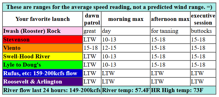
Not much uncertainty exists in Friday’s weather, but there’s some question of whether it will be windy enough. The 5am pressures (I was up early!) were 30.12/30.04/30.03 for gradients of 0.08/0.01. Models suggest those gradients will dip mid-morning and become marginally enough this afternoon. We’ll have 12-15 from Viento to Swell, then Stevenson to Hood River, into early afternoon. Models suggest we’ll see 16-19 from Stevenson to Doug’s, perhaps to Avery, from mid-afternoon on into the evening. East of Avery: light/variable wind all day. River flow over the last 24 hours was 149-200kcfs (159-200kcfs at Rufus), river temp is 57.4F, and high temp forecast is 73F with partly cloudy sky.

tomorrow’s gorge wind forecast
Saturday looks pretty darn light thanks to high pressure building inland and little-to-no support from Pacific Ocean dynamics. The day starts with 12-15 from Viento to Swell, but it drops below 10mph mid-morning and holds into the afternoon. There’s a hint of 15-18 from Stevenson to The Dalles after 5pm. High temp: 81F and mostly clear.
extended Gorge wind forecast
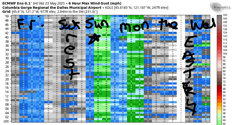
Sunday’s complicated, which isn’t ideal, but thermal gradients should save the day. A weak trough and attendant weak cold front approach from the coast, and a heat low develops in the desert. Flow aloft will be southerly, which tends to destabilize things, but the sounding model also has a stabilizing cap at 2000′ or so, which is helpful. Setting aside the technical aspects… you can expect dawn patrol at 24-27+ from Viento (or Stevenson) to Mosier with 20-23 east to Doug’s and light wind in the far east. By late morning, westerlies build to 28-32 from Stevenson to Doug’s with 26-29 from Avery to Arlington. Afternoon is a bit tricky, especially out east; models indicate 30-33 out in the desert, but they also suggest showers and possibly thunderstorms east of The Dalles. It appears you’ll be best served staying west of The Dalles, at least as of this morning. That could change. High temp: 78F with partly cloudy sky.
Clouds push inland Monday morning thanks to the aforementioned cold front. East of those clouds (probably from Mosier eastward), we’ll have 26-29+. Tuesday looks light. Wednesday could potentially bring a round of moderate easterlies. As we look at Thursday, we see an increase in uncertainty. We also see the possibility for a strong west wind day. Models are about 60% in on the “strong” aspect, and they’re 100% in on “windy enough”. That’s enough for now. Have a fantastic day today, whatever you do. See you on the Nch’i Wana soon!
Was that helpful? I knew it was! Guess what? All of this crucial work – from your personal wind and snow reports to the invaluable TATAS updates – is made possible by my relentless efforts. Maintaining this labor of love isn’t easy. Each daily forecast takes hours. Website hosting, weather model access, and back-end admin work takes time and money. That’s where you come in.
YOUR CONTRIBUTION MAKES A DIFFERENCE
- SUPPORT ACCURATE, HYPER-LOCAL WEATHER FORECASTING
- ENABLE ACCESS FOR ALL, EVEN THOSE WITH LESS MEANS
- SUPPORT A COOL HUMAN WHO WORKS HARD SO YOU CAN PLAY
Take a moment to click one of the buttons below. Donate $19.99 or more (how much does this forecast enhance your life?) and get the email in your inbox. Whether it’s a renewing subscription (auto-renew) or a one-time donation, every contribution makes a real difference. Help me keep this labor of love alive, so we can all continue playing, commuting, and living in the Gorge with peace of mind and the best weather forecasts possible. Thank you!


Hood River, Oregon 97031


JONES BEACH, SAUVIE ISLAND, & COAST FORECAST
Wind northerly unless otherwise indicated. For coast, it’s North/Central/South with the “central” at approximately Florence. Swell forecast from NWS for central coast. Jones: westerly unless otherwise stated. Sauvie Island: northerly unless otherwise stated. Friday: 10-015/15-20/25+, W swell 3′ at 9 seconds. Saturday: W 5-10/NW 10-15/N15-20, W 3′ @ 12. Sunday: SW10-15/SW10-15/S15, W 6′ @ 11. Jones Friday: 20-23. Saturday: 22-25. Sunday: LTW. Sauvie Island Friday: LTN. Saturday: 11-14 > 5pm. Sunday: LTW.
BARE BONES HOOD RIVER WEATHER FORECAST
Partly high overcast sky this morning might add a few lower clouds that dissipate later. Temps start in the low 50s and rise to the low 70s. Moderate westerlies. No rainbows. Saturday will be partly high cloudy then mostly clear. Temps start in the upper 40s and rise to 80 or so. Light westerlies early. Moderate late. No rainbows. Sunday will be partly cloudy. Temps start in the low 50s and rise to the upper 70s. Strong to nuking westerlies. No rainbows.
TEMIRA’S AWESOME TRAVEL ADVISORY SERVICE
HYPERLOCAL WEATHER FORECAST FOR THE COLUMBIA GORGE
THE DALLES, HOOD RIVER, WHITE SALMON, TROUT LAKE, STEVENSON, CASCADE LOCKS, PARKDALE, ODELL, HUSUM, BZ, MILL A, WILLARD, GOLDENDALE, RUFUS, ARLINGTON, boardman

Good morning, neighbors! Gotta keep it quick today, because I have a lot on my plate. That never seems to stop me from running my mouth, but hey, intention is worth something! Generally speaking, we have a warm weekend coming up followed by a cooler Memorial Day. Monday actually looks like the coolest day of the next ten as models have decided that we shall be around 80 degrees (in The Dalles, anyway) starting next Tuesday and continuing through the first week of June.
friday’s gorge weather forecast
But not today! It’s Friday, thank the fucking stars, and we’ll only max out in the low-mid 70s. Glenwood started at 36 degrees this morning, not good for growing stuff in the garden, but excellent for cooling your house off overnight. Intermittent high clouds slip in and out of the area today like a lover slipping in and out of your bedroom window when you were young enough for that to be necessary. Kids, don’t try that at home. Westerlies pick up to 15mph or so between Stevenson and The Dalles. Areas to the east remain rather calmish today. See if you can get your nervous system to mirror the wind speed. You’ll feel much better if you can master that trick.
Before I forget, Gary is starting his world record pumpkin paddle attempt (round II) this afternoon at 3:30pm. Wish him luck!
saturday’s gorge weather forecast
A few high clouds Saturday morning set us up for another colorful sunrise (like Friday’s). It will be plenty warm (upper 40s in the lowlands) to watch that sunrise while you sip a cup of strong coffee. But not mushroom coffee, because that’s not coffee. It’s something else. By afternoon, we’ll be mostly clear and 80 degrees. It’s gonna feel hot, cuz there won’t be much wind: 10mph early from Stevenson to Hood River, less than 10mph midday, and 15mph in the evening from Stevenson to The Dalles. East of there: calm, warm, and sunny.
NWS is reminding people that jumping in cold rivers could result in cold water shock. You’ll be tempted to jump in a cold river Saturday or Sunday. Just remember that you could get cold water shock, which is worse than an electric shock (oh, the dumb ways I’ve accidentally shocked myself) and not as awesome as having good shocks on your car. How does TATAS define “good shocks”? Well, that’s when your shocks have a good place for you to hide your key, a place that can easily be described to your friends so they can drive your car back for you.
sunday’s gorge weather forecast
On Sunday, we have “interesting” weather. There’s a slight chance of showers/thundershowers especially from the Cascade Crest to the east. We’ll also have very strong wind (Stevenson to Arlington), strong enough that you’ll feel the Boardhead energy vibrating through the ether. Tap into it for a source of unlimited, but conditional, joy and excitement. Head to the Spring Creek Hatchery to watch the Nch’i Wana (Columbia) do its magic: the swell will be as large as the grins on the Wind Johnny faces. Temps max out in the upper 70s on Sunday after a low 50s start.
memorial day gorge weather forecast
Cooler weather Monday portends an excellent day for barbecue. If you’ve been reading closely, you’ll have noticed that TATAS isn’t particular about weather when it comes to cooking meat outdoors on a grill. Any weather is good for that. I learned that from McCurdy Farms, masters of the winter barbecue. Safe travels. -TATAS
HEY! DON’T STOP READING! Is this community-focused forecast helpful to you? It sure is! It takes me a couple hours a day to write. Please join your friends and neighbors in contributing to keep it going. Venmo: @thegorgeismygym PayPal: twomirrors@gmail.com USPS: Temira / PO Box 841 / Hood River, Oregon 97031 You can test out the forecast subscription for a few days for free by signing up below. Easy! Do it!
