

GORGE WIND FORECAST
If you’re still seeing yesterday’s and it’s after 9am, try opening this in an incognito window
today’s gorge wind forecast
Hi friends! I hope you had a wonderful week and were able to get in the river and cool off! A decent stretch of onshore flow (west wind) is in the Gorge wind forecast for the next several days (probably longer), but the picture is complicated by thunderstorm potential and disturbances moving through for the Friday-Sunday period. After that, offshore low pressure and actual honest-to-gosh rain enter the picture, but the westerlies (probably) stick around.
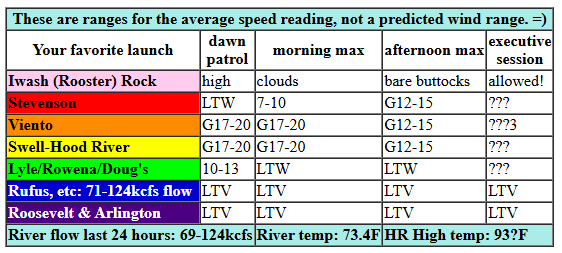
Looking at Friday morning, I see raindrops! Pressures at 7am were 29.84/29.76/29.79 for gradients of 0.08/E0.03. Models have thunderstorm chances both this morning and this evening with lesser chances midday. Best chance of wind is this morning before heating kicks in and knocks down pressures. You’ll have a chance (thunderstorms permitting) of 17-20mph from Viento to the Hatch for several hours this morning. Hood River may join in at 14-17mph. That said, passing storms will (and have) made the wind speed vary wildly. Don’t expect consistency! By late morning or early afternoon, the wind falls to 12-15mph and fills in between Stevenson and Hood River. Again, not much consistency. To the east, the wind will be 10mph or less all day. After 2pm, all bets are off due to increasing instability and thunderstorm chances. River flow over the last 24 hours was 69-131kcfs, river temp is 73.4F, and high temp forecast is 93F. If these clouds stick around, we’re unlikely to get that warm.
RIVER FLOW FOR SITES BETWEEN AVERY (EAST OF THE DALLES) AND RUFUS: CLICK HERE FOR JOHN DAY DAM FLOW.
RIVER FLOW FOR SITES BETWEEN STEVENSON AND DOUG’S BEACH (WEST OF THE DALLES): CLICK HERE FOR THE DALLES DAM FLOW

tomorrow’s gorge wind forecast
After a somewhat stable Saturday morning, we’re in for another round of thunder in the afternoon. In between: wind! Models suggest 21-24mph from Viento to Mosier (17-20mph in Hood River) to start the day with 13-16mph from Lyle to Arlington. The wind holds all morning thanks to low clouds in the metro area; we’ll have 21-24mph from Stevenson to Mosier into early afternoon. A disturbance arriving after 2pm threatens destabilization and thunderstorms. There’s some sign of stronger wind, 26-29mph, from Lyle to Rufus, but that could fail to materialize if storms arrive. High temp: 83F for Hood River and 91F at Rufus.
extended Gorge wind forecast
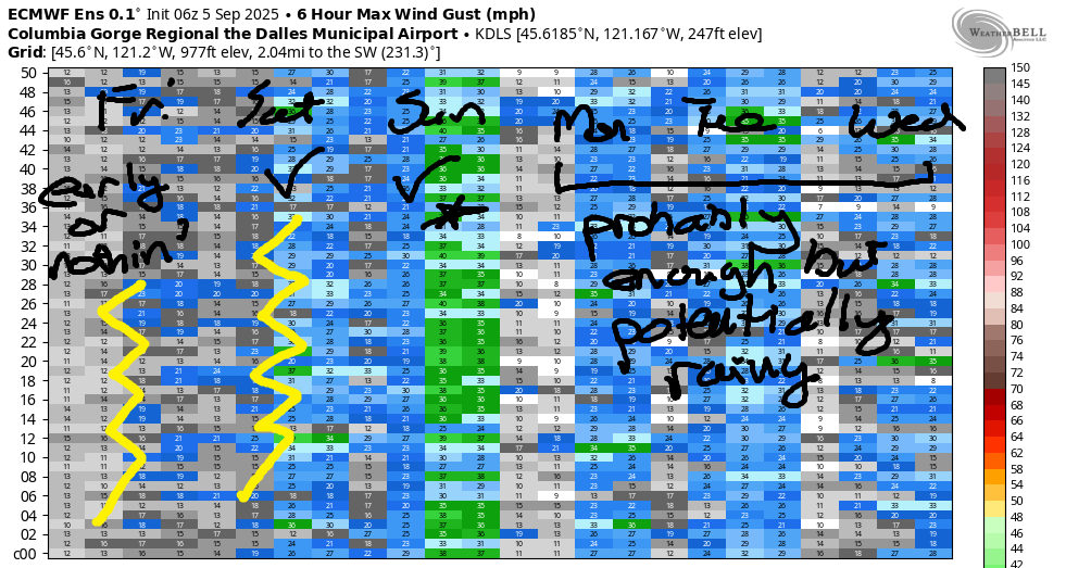
Sunday morning continues the thunderstorm story, but things look to stabilize in the afternoon. As of right now, models have us with 22-25mph from Viento to Arlington early with 24-27mph from Stevenson to Arlington by early afternoon. The Lyle-Arlington stretch holds potential for 28-31mph. I feel skeptical, as do the Euro ensembles. Don’t pencil that in yet. High temp: 79F for Hood River and 89F out in the desert.
A different sort of pattern settles in starting Monday: an offshore low, cooler temps, and the potential for actual rain. With the desert remaining warm, west wind potential continues. Euro ensemble internal consistency is good for the Monday-Tuesday period; both look like they’ll have 17-20mph or more somewhere, probably out east. Agreement drops on Wednesday, so I’ll leave it there for now. Stay safe out there today; get off the water if you see thunderstorms building. Don’t wait until you hear thunder to get clear. Hope to see you on the Nch’i Wana!
Was that helpful? I knew it was! Guess what? All of this crucial work – from your personal wind and snow reports to the invaluable TATAS updates – is made possible by my relentless efforts. Maintaining this labor of love isn’t easy. Each daily forecast takes hours. Website hosting, weather model access, and back-end admin work takes time and money. That’s where you come in.
YOUR CONTRIBUTION MAKES A DIFFERENCE
- SUPPORT ACCURATE, HYPER-LOCAL WEATHER FORECASTING
- ENABLE ACCESS FOR ALL, EVEN THOSE WITH LESS MEANS
- SUPPORT A COOL HUMAN WHO WORKS HARD SO YOU CAN PLAY
Take a moment to click one of the buttons below. Donate $19.99 or more (how much does this forecast enhance your life?) and get the email in your inbox. Whether it’s a renewing subscription (auto-renew) or a one-time donation, every contribution makes a real difference. Help me keep this labor of love alive, so we can all continue playing, commuting, and living in the Gorge with peace of mind and the best weather forecasts possible. Thank you!


Hood River, Oregon 97031


JONES BEACH, SAUVIE ISLAND, & COAST FORECAST
Wind northerly unless otherwise indicated. For coast, it’s North/Central/South with the “central” at approximately Florence. Swell forecast from NWS for central coast. Jones: westerly unless otherwise stated. Sauvie Island: northerly unless otherwise stated. Coast Friday: NW10-15/LTNW/LTS, NW swell 3′ at 6 seconds. Saturday: W5-10/W5-10/S5-10, NW swell 2′ @ 7. Sunday: W 5-10/LTW/LTS, seas 2′ or less. Jones Friday: 15-18. Saturday: 12-15. Sunday: LTW. Sauvie Island Friday: 11-14. Saturday: 7-10. Sunday: less than 10mph.
BARE BONES HOOD RIVER WEATHER FORECAST
Mixed clouds with a slight chance of thunder this morning. Mixed clouds with a good chance of thunder after 5pm. Temps start in the upper 60s (record high low territory) and rise to the low 90s. Moderate westerlies. 4% chance of rainbows. Saturday will be cloudy with a good chance of thunder after 2pm. Temps start in the low 60s and rise to the low 80s. Moderate westerlies. 26% chance of rainbows. Sunday will be cloudy with a slight chance of thunderstorms then partly cloudy. Temps start in the low 60s and rise to the upper 70s. Moderately strong westerlies. 3% chance of rainbows.
TEMIRA’S AWESOME TRAVEL ADVISORY SERVICE – FRIDAY
HYPERLOCAL WEATHER FORECAST FOR THE COLUMBIA GORGE
THE DALLES, HOOD RIVER, WHITE SALMON, TROUT LAKE, STEVENSON, CASCADE LOCKS, PARKDALE, ODELL, HUSUM, BZ, MILL A, WILLARD, GOLDENDALE, RUFUS, ARLINGTON, boardman
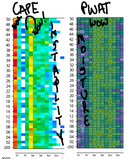
Good morning, neighbors! I hope you had a great week while I was off on a meditation retreat. I had a great week in silence with sangha. Best. Thing. Ever. And now I’m coming home to massive PWAT, rain, and thunderstorm chances. A fun forecast is on tap. For a visual hint, check out the CAPE and PWAT on the image.
Glenwood this morning
Starting the day with our friends in Glenwood, we’ve got 58 degrees up there. At my place in Hood River, there’s rain, glorious rain! All the people in all the boats out fishing for all the salmon in front of the White Salmon are getting wet, and they’re all happy because rain makes the fish bite. Apparently. That said, with the river at 73.4 degrees, those fish are suffering. The ideal temp for spawning salmon is below 68 degrees, with optimal conditions 55-64 degrees. Temperatures above 72 degrees can be lethal. Climate. Change. Is. Real.
Today’s Gorge weather forecast
Looking at today’s weather, we were real close to setting a record high-low in Hood River (we set one yesterday, and we set a record high-high a few days ago). But then the rain came through, and I’m guessing evaporative cooling knocked the temp down. But I don’t feel like messing with the agrimet website again to find out. Larry will let us know later.
Anyway, today we have lots of excitement. Instability this morning gives us a chance of thunderstorms and rain showers. Another stronger round of instability this afternoon into tonight gives us a better chance of thunderstorms. With PWAT (available moisture) well over 1.0”, any storms that form could drop copious rain. PLEASE LET THAT HAPPEN! While the high temp forecast is in the low to mid 90s today, cloud cover could protect us from that. Hot or not, it’ll still be warm and muggy all day long. West wind will be 15-20mph from Viento to the White Salmon early, 12-15mph from mid-morning on, and unpredictable in the evening thanks to storms. Other than with passing storms, the wind east of Mosier should stay under 10mph today.
Saturday’s Gorge weather forecast
Thunderstorm potential lingers east of The Dalles early on Saturday, and then things settle down during the day. We’ll still have plenty of mixed-level clouds around. West of Hood River, the day starts with low clouds, which will keep temps down some. After a 60-65 degree start, we finish with 83 (west) and 90-92 (The Dalles and eastward). After 2pm, maybe after 5pm, a disturbance arrives from the south. This destabilizes the fuck (technical term) out of the atmosphere (SO MUCH CAPE) and fires off thunderstorms. PWAT (available moisture) will be well over 1.0”. Any storms could make downpours. In addition, hail is possible if storms get really big (SORRY FARMERS – I LOVE THE FARMERS). Last thing to mention: west wind will be 20-25mph between Viento and Mosier to start with 15mph east of Mosier to Arlington. Afternoon: 20-25mph from Stevenson to Hood River and 25-30mph from Bingen to Rufus with 25mph at Arlington. Not the nicest fishing weather!
Thunderstorm and rain potential continues overnight and into Sunday morning.
Extended Gorge weather forecast
Stabilization happens on Sunday, finally. After a 60ish degree start, temps rise to 79F (west side), 84F (The Dalles), and 89F (The Desert). West wind will be 20-25mph from Viento to Arlington in the morning with 25-30mph from Stevenson to Arlington in the afternoon.
Starting Monday, temps drop below 80F for pretty much all of us. Also possible: a bit of rain. Low pressure settles in offshore and taps into a couple sigmas of available moisture (SO MUCH AVAILABLE MOISTURE BETWEEN NOW AND THEN). This low will send frontal systems inland. That causes lift, and that causes rain. Models don’t have a ton of rain, but at least temps will be cooler than they’ve been lately. Looking way out into the future, meaning the next couple of weeks, temps look to stay (generally) below 80 degrees from Sunday on. I’m breathing a big sigh of relief. Safe travels. -TATAS
HEY! DON’T STOP READING! Is this community-focused forecast helpful to you? It sure is! It takes me a couple hours a day to write. Please join your friends and neighbors in contributing to keep it going. Venmo: @thegorgeismygym PayPal: twomirrors@gmail.com USPS: Temira / PO Box 841 / Hood River, Oregon 97031 You can test out the forecast subscription for a few days for free by signing up below. Easy! Do it!
