

GORGE WIND FORECAST
If you’re still seeing yesterday’s and it’s after 9am, try opening this in an incognito window
today’s gorge wind forecast
Hi friends! Yesterday sure was a weird one – not only did the wind refuse to cooperate with the forecast at the Hatch, but there was massive, glassy swell despite the light wind. Go figure. With instability out of the picture today, the wind is more likely to do what the models say. That said, models are notoriously unreliable this time of year. Speaking of unreliable – I’ll be out of town helping with a retreat through Monday. I’ll try and get a wind forecast (but not the rest of the forecast) out for ya. Fingers crossed!
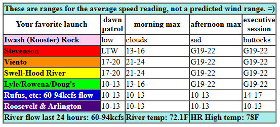
Friday started off with pressures of 30.09/29.99/29.99 for gradients of 0.10 from PDX to DLS. Marine clouds are forecast to stick around for the first half of the day west of Hood River. Dawn Patrol wind was 20-23mph from Viento to the Hatch with 10-13mph at Stevenson and locations east of Hood River. We’ll see 21-24mph all morning near the Hatch with the wind filling in from Stevenson to Mosier by late morning. Afternoon wind may be affected by a front well offshore; if that’s the case, we’ll see gusty 19-22 from Stevenson to Doug’s with 14-17mph at Avery. River flow over the last 24 hours was 60-94kcfs, river temp is 72.1F, and high temp forecast is 78F for Hood River.
RIVER FLOW FOR SITES BETWEEN AVERY (EAST OF THE DALLES) AND RUFUS: CLICK HERE FOR JOHN DAY DAM FLOW.
RIVER FLOW FOR SITES BETWEEN STEVENSON AND DOUG’S BEACH (WEST OF THE DALLES): CLICK HERE FOR THE DALLES DAM FLOW

tomorrow’s gorge wind forecast
A brief ridge builds in on Saturday and knocks the gradients down. That said, there’s some indication of morning marine clouds in Portland which will assist midday wind. Early wind looks like 10-13mph from Viento to the Hatch (better for fishing than wind sports!). Midday westerlies rise to 16-19mph from Stevenson to Doug’s with 5-10mph in the eastern Gorge. An approaching system in the afternoon nudges the wind down to 14-17mph form Stevenson to Hood River, nudges it up from Mosier to Rufus (18-21mph) and even invites Arlington to join the fun (13-16mph). High temp: 82F unclear clear sky.
extended Gorge wind forecast
Sunday brings a potential round of drizzle all through the Gorge, all the way east to Boardman. Models have us with 11-14mph in the morning. Despite calling for drizzle, models also call for afternoon wind. I’m skeptical. Models say 14-17mph from Stevenson to Doug’s with 20-23mph from Lyle to Arlington. With rain. Seems low-probability to me.
Ridging builds in on Monday. After a brief west wind dawn patrol, the wind goes light or even easterly. Tuesday brings easterlies at perhaps 25mph. Ensembles and the GFS deterministic suggest a trough (cool air) will approach the coast on Wednesday. If this happens, we could see a solid west wind day. Fingers crossed for that. Okay. That’s all for now. I need to get ready for a 9am meeting and also get myself ready to get out of town. Hopefully I can get you a brief wind forecast over the next few days in between my commitments at Cloud Mountain. See you on the Nch’i Wana!
Was that helpful? I knew it was! Guess what? All of this crucial work – from your personal wind and snow reports to the invaluable TATAS updates – is made possible by my relentless efforts. Maintaining this labor of love isn’t easy. Each daily forecast takes hours. Website hosting, weather model access, and back-end admin work takes time and money. That’s where you come in.
YOUR CONTRIBUTION MAKES A DIFFERENCE
- SUPPORT ACCURATE, HYPER-LOCAL WEATHER FORECASTING
- ENABLE ACCESS FOR ALL, EVEN THOSE WITH LESS MEANS
- SUPPORT A COOL HUMAN WHO WORKS HARD SO YOU CAN PLAY
Take a moment to click one of the buttons below. Donate $19.99 or more (how much does this forecast enhance your life?) and get the email in your inbox. Whether it’s a renewing subscription (auto-renew) or a one-time donation, every contribution makes a real difference. Help me keep this labor of love alive, so we can all continue playing, commuting, and living in the Gorge with peace of mind and the best weather forecasts possible. Thank you!


Hood River, Oregon 97031


JONES BEACH, SAUVIE ISLAND, & COAST FORECAST
Wind northerly unless otherwise indicated. For coast, it’s North/Central/South with the “central” at approximately Florence. Swell forecast from NWS for central coast. Jones: westerly unless otherwise stated. Sauvie Island: northerly unless otherwise stated. Coast Friday: NW5-10/N10-15/N20, NW swell 6′ at 14 seconds and SW 2′ @ 14. Saturday: W5-10/W5-10/LTV, NW 6′ @ 13 and SW 2′ @ 14. Sunday: NW5-10/NW5-10/N20-25, W 5′ @ 11 and SW 2′ @ 14. Jones Friday: 7-10. Saturday: 12-15. Sunday: 10-13. Sauvie Island Friday: LTN. Saturday: 11-14 > 5pm. Sunday”: NW 5-10.
BARE BONES HOOD RIVER WEATHER FORECAST
Sunny today. Temps start in the low 60s and rise to the upper 70s. Moderately strong westerlies. NO rainbows. Saturday will be clear then partly high cloudy. Temps start in the low 50s and rise to the lo w80s. Light westerlies early. Moderate later. No rainbows. Sunday will be cloudy with light drizzle. Temps start in the upper 50s and rise to 70. Light to moderate westerlies. 86% chance of rainbows.
TEMIRA’S AWESOME TRAVEL ADVISORY SERVICE
HYPERLOCAL WEATHER FORECAST FOR THE COLUMBIA GORGE
THE DALLES, HOOD RIVER, WHITE SALMON, TROUT LAKE, STEVENSON, CASCADE LOCKS, PARKDALE, ODELL, HUSUM, BZ, MILL A, WILLARD, GOLDENDALE, RUFUS, ARLINGTON, boardman

Good morning, neighbors! It’s another lovely late summer day here in the Gorge. I’m heading back to Cloud Mountain for the weekend, and my housesitter declined to do a forecast. Sheesh. TATAS will see you again on Tuesday. In the meantime, your weekend forecast…
But first, Glenwood. We’re back to normal there with a low 0f 43 degrees this morning, almost 20 degrees lower than the “low” in the Hood River. But don’t you worry: we’ll all warm up today: upper 70s in Hood River, low 80s in The Dalles, and mid 80s in the desert. Expect west wind at 20-25mph from Viento to Hood River this morning with 20ish mph between Stevenson and Avery this afternoon. To the east: lighter. Clouds persist through midday west of Viento.
A brief ridge brings warmer weather on Saturday. Sunshine sticks around until the evening, when high clouds arrive from the west. Temps max out at 82-88 degrees, hottest in the east. West wind will be 10mph early between Viento and the White Salmon Bridge (not too bad for chasing those 15,000 fish/day coming over Bonneville!) and 15-20mph in the afternoon between Stevenson and Arlington.
More interesting weather is forecast on Sunday as a cold front swings through. We’ll see drizzle west of The Dalles with actual rain from The Dalles eastward and in South Wasco County. Rainfall predictions are all over the place at this point. So no certainty, sorry! West wind will be 10-15mph from Stevenson to Boardman in the morning and 20-25mph in the afternoon east of Hood River. Highs range from 70 (quite pleasant!) in Hood River to 75F (quite pleasant!) in The Dalles and areas to the east.
Monday’s a dry day, a transition day. Starting Tuesday, warmer, low-humidity weather is forecast. A heat low sets up on the west side and gives us sunshine, east wind, and 80 degree temps. Models hint at a trough approaching the coast Wednesday and setting up a very windy (west wind) day in the Gorge. As for rain… still no clear and consistent signs in the extended ensembles. But there are some signs, and some signs are better than no signs. Well, I guess it depends on what the signs actually say, but these signs say “rain, maybe”. Safe travels. -TATAS
HEY! DON’T STOP READING! Is this community-focused forecast helpful to you? It sure is! It takes me a couple hours a day to write. Please join your friends and neighbors in contributing to keep it going. Venmo: @thegorgeismygym PayPal: twomirrors@gmail.com USPS: Temira / PO Box 841 / Hood River, Oregon 97031 You can test out the forecast subscription for a few days for free by signing up below. Easy! Do it!
MT HOOD SNOW FORECAST

CURRENTLY ON VACATION. WILL RETURN SOMETIME BEFORE THE START OF SKI SEASON AT MEADOWS, TIMBERLINE AND SKIBOWL. SAME GOES FOR THE NORDIC SKIING SEASON AT MEADOWS AND TEACUP!
