

GORGE WIND FORECAST
If you’re still seeing yesterday’s and it’s after 9am, try opening this in an incognito window
today’s gorge wind forecast
Hi friends! “Windy” is a good descriptor for the start of Friday. Many spots were already above 20mph as I was scrambling to get this forecast done. With clouds in the metro area, solid offshore high pressure, and a hot day forecast for the desert, we’ve got a good setup for a good day on the river. Same goes for Saturday. We lose our offshore support starting Sunday and keep the cross-Cascade temp differential, for several days of lesser westerlies. Overall, westerlies continue through next week, but significant elevated instability for the middle part of next week could interfere with the wind… PSA: Doug’s and Lyle remain closed due to the Burdoin Fire, and SR-14 remains closed between Bingen and Lyle. If you see planes/helis scooping water near where you are recreating, get off the river and go somewhere else. Let’s support our fire crews and folks who are still evacuated.
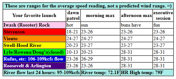
Looking at Friday morning, I see lots of whitecaps in front of my place. Pressures at 7am were 30.06/29.92/29.87 for gradients of 0.14 (PDX-DLS) and 0.05 (DLS-PSC). That’s solid! Wind speeds on the iWind/iKite sensors were generally 20-24mph (Swell, Viento, Stevenson, Rufus, Arlington) with teens near Rowena. Westerlies rise to 23-27mph between Stevenson and Rufus this morning (Rowena will be slower to join). In the afternoon, we’ve got 23-26 from Stevenson to Mosier with 28-32mph from Rowena to Rufus and 26-29mph at Arlington. Threemile: 22-25mph, but not until mid-afternoon. River flow over the last 24 hours was LOW – 95-109kcfs, river temp is 72.1F (poor salmon), and high temp forecast is 79F for Hood River and 90F near Arlington.
RIVER FLOW FOR SITES BETWEEN AVERY (EAST OF THE DALLES) AND RUFUS: CLICK HERE FOR JOHN DAY DAM FLOW.
RIVER FLOW FOR SITES BETWEEN STEVENSON AND DOUG’S BEACH (WEST OF THE DALLES): CLICK HERE FOR THE DALLES DAM FLOW

tomorrow’s gorge wind forecast
Saturday kicks off with a nice marine layer in the metro area and clear sky to the east. With less offshore support and somewhat cooler temps in the desert, the wind will be down a couple notches. For Dawn Patrol, we see 17-20mph from Viento to Mosier with 14-17mph at Stevenson and east of Mosier to Arlington. Midday wind rises to 21-24 from Stevenson to Rufus with 17-20mph at Arlington. Models suggest clearing in the metro area and an accompanying drop in the wind near the Hatch in the afternoon. Call it 16-19mph there. Elsewhere, you’ll find 18-21mph from Stevenson to Viento and 24-27mph from Mosier to Rufus. Arlington hangs steady with 17-20mph. High temp: 79F for Hood River and upper 80s out in the desert.
extended Gorge wind forecast
Heating on the west side and diminished offshore high pressure takes the wind down another rung on Sunday. As of this morning, it’s looking like 20-23mph from Stevenson to Mosier in the morning. Afternoon brings 16-19mph from Stevenson to Hood River with 20-23mph from Mosier to Rufus and 14-17mph east of Rufus. High temp: 83F for Hood River and 90ish near Rufus.
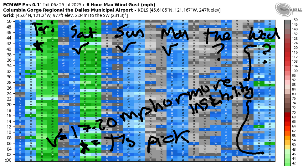
Ensembles give a similarly strong day on Monday, lighter wind on Tuesday, and potentially stronger wind on Wednesday. Next week’s biggest day is likely to be Thursday or Friday (with wind continuing through next weekend), but there’s a ton of uncertainty in the current model run. Elevated thunderstorms are possible Tuesday into Wednesday as well, which would cause all sorts of disruptions. So, let’s leave it there for now. Today looks like an excellent one on the river. Have fun, and be safe! I’ll see you on the Nch’i Wana!
Was that helpful? I knew it was! Guess what? All of this crucial work – from your personal wind and snow reports to the invaluable TATAS updates – is made possible by my relentless efforts. Maintaining this labor of love isn’t easy. Each daily forecast takes hours. Website hosting, weather model access, and back-end admin work takes time and money. That’s where you come in.
YOUR CONTRIBUTION MAKES A DIFFERENCE
- SUPPORT ACCURATE, HYPER-LOCAL WEATHER FORECASTING
- ENABLE ACCESS FOR ALL, EVEN THOSE WITH LESS MEANS
- SUPPORT A COOL HUMAN WHO WORKS HARD SO YOU CAN PLAY
Take a moment to click one of the buttons below. Donate $19.99 or more (how much does this forecast enhance your life?) and get the email in your inbox. Whether it’s a renewing subscription (auto-renew) or a one-time donation, every contribution makes a real difference. Help me keep this labor of love alive, so we can all continue playing, commuting, and living in the Gorge with peace of mind and the best weather forecasts possible. Thank you!


Hood River, Oregon 97031


JONES BEACH, SAUVIE ISLAND, & COAST FORECAST
Wind northerly unless otherwise indicated. For coast, it’s North/Central/South with the “central” at approximately Florence. Swell forecast from NWS for central coast. Jones: westerly unless otherwise stated. Sauvie Island: northerly unless otherwise stated. Coast Friday: NW5-10/NW10/N20-25, NW swell 3′ at 8 seconds. Saturday: LTNW/LTNW/N20, NW 3′ @ 8. Sunday: NW5-10/NW10-15/N15, NW 3′ @ 8. Jones Friday: 13-16. Saturday: 16-19. Sunday: 14-17. Sauvie Island Friday: 9-12. Saturday: 12-15. Sunday: 7-10.
BARE BONES HOOD RIVER WEATHER FORECAST
Clear sky all day. Temps start in the low 60s and rise to the upper 70s. Strong westerlies. No rainbows. Saturday will be partly cloudy then clear. Temps start in the mid 50s and rise to the upper 70s. Moderately strong westerlies. No rainbows. Sunday will be sunny. Temps start in the mid 50s and rise to the low 80s. Moderate westerlies. No rainbows.
TEMIRA’S AWESOME TRAVEL ADVISORY SERVICE – FRIDAY 7/25
HYPERLOCAL WEATHER FORECAST FOR THE COLUMBIA GORGE
THE DALLES, HOOD RIVER, WHITE SALMON, TROUT LAKE, STEVENSON, CASCADE LOCKS, PARKDALE, ODELL, HUSUM, BZ, MILL A, WILLARD, GOLDENDALE, RUFUS, ARLINGTON, boardman
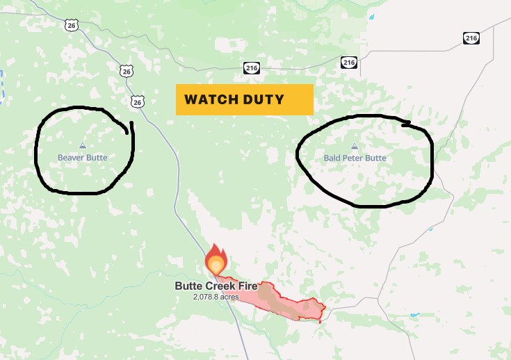
Good morning, neighbors! Highlights of the upcoming week of weather include the following: cooler temps for the Friday-Saturday period, hot weather for the Monday-Wednesday period, a decent chance of thunderstorms in the Tuesday-Wednesday period, and a cooldown for the latter half of next week. Checking in on the fires this morning, we have almost no growth on Snyder Canyon and 13% containment; little growth on the Burdoin Fire and also 13% containment; almost no growth on the Butte Creek Fire (on the Warm Springs Reservation in south Wasco County) with 30% containment. That fire has gotten less attention despite being over 2000 acres. Maybe because it’s located to the SW of Beaver Butte and SE of Bald Peter Butte, and… um, seriously?!!?
glenwood this morning and today’s gorge weather forecast
Up in Glenwood this morning, there are no dirty place names. The day started at 47 degrees, just warm enough for knowing looks between the residents. The rest of us started warmer – 63 degrees at my place – and breezy. Temps climb to perfectly reasonable heights today: upper 70s to the west, mid 80s for The Dalles, and mid 90s out where the watermelons of Hermiston are being harvested. West wind climbs to 25mph (average speed) west of Mosier with 25-35mph east of Mosier to Arlington this afternoon. Up in the hills: west 15mph.
saturday’s gorge weather forecast
Overnight, low clouds eventually infiltrate the Gorge west of Hood River. For the rest of us, Saturday starts clear. It’ll be a good night for sleeping: temps drop into the 50s overnight. Afternoon highs will be about the same as Friday’s. In the wind department, we start with 15-20mph between Viento and Mosier and rise to 25mph from Stevenson to Rufus with 20mph out near Arlington. Hills: SW 15-20mph, which kicks off a few little fluffy clouds especially south of the Big River.
sunday’s gorge weather forecast
After a 50-something degree start, Sunday’s temps will be up a few degrees: low 80s to the west, upper 80s in The Dalles, and low 90s out where the watermelons roam and the Bighorn Sheep groan. They’re groaning because it’s hot every day and they’re furry and fluffy and can’t sweat. If they could, they’d smell really bad because they also can’t shower. Westerlies start the day at 15-20mph west of Mosier and rise to 20-25mph from Stevenson to Rufus with 15mph east of Rufus to the Arlington Isosceles Triangle.
extended gorge weather forecast
We’ll continue with the warming trend and westerly breeze (at least west of The Dalles – wind speeds will likely drop off to the east) to start next week. Highs for The Dalles will be around 100 on Tuesday and Wednesday. BUT WAIT, THERE’S MORE! Southerly flow aloft drags monsoonal moisture this way in the Tuesday-Thursday time frame. Instability cranks up like Arthur B’s Model T, and thunderstorms enter our list of possibilities. While temps are likely to drop on Thursday (and potenitally plummet, which is like dropping only bigger and faster), the mugginess sticks around through thursday or Friday. We’ll be keeping a close eye on the weather for the middle part of next week thanks to the thunderstorm/rain possibilities. Until then… safe travels. -TATAS
HEY! DON’T STOP READING! Is this community-focused forecast helpful to you? It sure is! It takes me a couple hours a day to write. Please join your friends and neighbors in contributing to keep it going. Venmo: @thegorgeismygym PayPal: twomirrors@gmail.com USPS: Temira / PO Box 841 / Hood River, Oregon 97031 You can test out the forecast subscription for a few days for free by signing up below. Easy! Do it!
