

GORGE WIND FORECAST
If you’re still seeing yesterday’s and it’s after 9am, try opening this in an incognito window
today’s gorge wind forecast
Hi friends! It’s race day for the Gorge Downwind Champs: 900 boats and some truly impressive SUP people will be heading from Home Valley to the Hood River Waterfront Park today. Race start is 11am. Today will be windy, and so will the weekend. Uncertainty increases and wind speeds (probably) decline starting Monday, but we’ll dive into that more when we hit the extended Gorge wind forecast a few paragraphs from now.
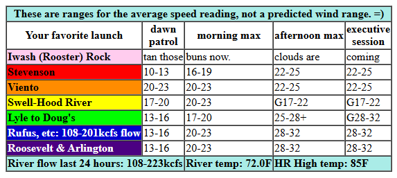
Looking at Friday’s start, we have pressures of 29.98/29.87/29.84 for gradients of 0.11 (PDX-DLS) and 0.03 (DLS-PSC). Wind speeds as I was writing were generally 10-13mph with the exception of Viento (20-23mph – usually reads high) and Swell (15-18mph). (TLDR) As a shortwave trough (cooler air, essentially) pushes towards us today, a couple things will happen: first, the wind field is likely to destabilize on the west side as cool air pushes inland; second, a solid cross-Cascade temp gradient will develop; third, upper level winds will increase and kick in a little lee-side troughing (low pressure to the east) and elevated assistance to the wind. The timing isn’t quite right for perfection – I’d prefer to see the system approaches earlier which would do all sorts of good stuff – but it’s going to be good enough.
Expect a quick build to 20-23mph from Viento to Mosier this morning with 17-20mph from Lyle to Rufus and 16-19mph at Stevenson. Given the disruption from the approaching system, it’s possible the Swell-Hood River zone will drop to gusty 17-22 late morning or early afternoon and hold. Stevenson to Viento should rise to 22-25; Mosier to Doug’s rises to 25-28mph, and Avery to Arlington rises to 28-32mph. If that’s not widespread enough for you, hold out until late afternoon when we should see 28-32mph between Lyle and Threemile. Given the approaching system, it’s likely the wind will be rather up-and-down. It should steady out some after 2pm when the cool air really starts to push in to the west side. Last thing: Keep in mind that those eastern Gorge sensors read high compared to Swell; 28-32mph out east is equivalent to about 24-27mph on the Swell sensor. Yadda yadda yadda… it’s going to be a windy day! River flow over the last 24 hours was 108-223kcfs (108-201kcfs at Rufus), river temp is 72.0F (poor salmon!), and high temp forecast is 85F for Hood river and 95F for Arlington.
RIVER FLOW FOR SITES BETWEEN AVERY (EAST OF THE DALLES) AND RUFUS: CLICK HERE FOR JOHN DAY DAM FLOW.
RIVER FLOW FOR SITES BETWEEN STEVENSON AND DOUG’S BEACH (WEST OF THE DALLES): CLICK HERE FOR THE DALLES DAM FLOW

tomorrow’s gorge wind forecast
Moving on to Saturday: cool air and troughing will be in place on the west side, and a robust (11 degree) cross-Cascade temp gradient is forecast to develop. We start with 22-25mph from Viento to Arlington with 17-20mph at Stevenson. TJ’s Dawn Patrol looks like a go! Midday wind rises to 25-28mph from Viento to Mosier with 22-25mph from Lyle to Arlington. Afternoon: the west side, Stevenson to Mosier, holds at 24-28mph, and Lyle to Rufus rises to 26-30mph Arlington: 22-25mph. High temp: 79F for Hood River and 87F for Arlington.
extended Gorge wind forecast
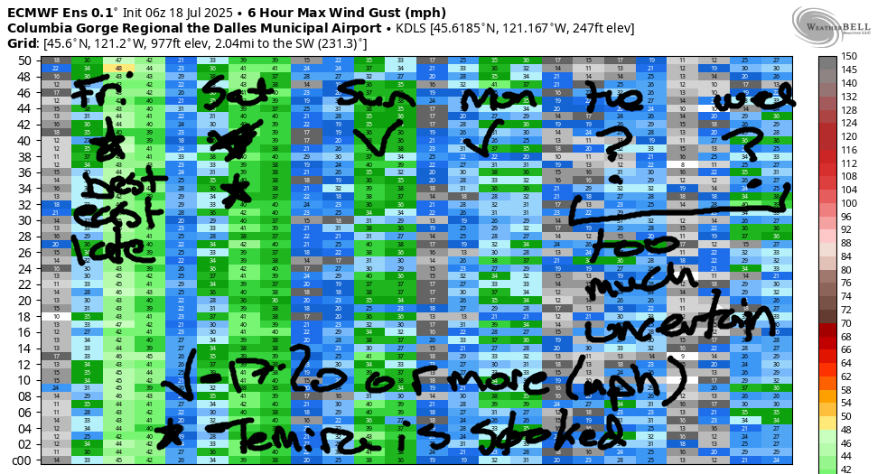
Quite a few moving pieces enter the Sunday forecast. I’ll spare you the TLDR for now. Generally speaking, we should see low 20s from Viento to Mosier to start the day. It’s almost certain (unless something changes) that the Swell-Hood River zone will drop to the teens in the afternoon while Mosier-Rufus rises to the mid 20s. High temps will be 78F near Hood River and 88F near Rufus.
We start to see quite a bit of range in the ensemble forecast from Monday onward. It’s likely we’ll see 17-20mph or more on Monday. Beyond that: less certainty, although models have lighter wind on Tuesday and slightly more wind for Wednesday. The starts of next week, at least from this far-out view, appear to be Thursday and Friday, but we’ll need to get a lot closer to those days to see if 1) this pans out and 2) just how strong the wind will be. Have a great day out there today. Be kind to each other – we’re all out shredding and having fun! See you on the Nch’i Wana!
Was that helpful? I knew it was! Guess what? All of this crucial work – from your personal wind and snow reports to the invaluable TATAS updates – is made possible by my relentless efforts. Maintaining this labor of love isn’t easy. Each daily forecast takes hours. Website hosting, weather model access, and back-end admin work takes time and money. That’s where you come in.
YOUR CONTRIBUTION MAKES A DIFFERENCE
- SUPPORT ACCURATE, HYPER-LOCAL WEATHER FORECASTING
- ENABLE ACCESS FOR ALL, EVEN THOSE WITH LESS MEANS
- SUPPORT A COOL HUMAN WHO WORKS HARD SO YOU CAN PLAY
Take a moment to click one of the buttons below. Donate $19.99 or more (how much does this forecast enhance your life?) and get the email in your inbox. Whether it’s a renewing subscription (auto-renew) or a one-time donation, every contribution makes a real difference. Help me keep this labor of love alive, so we can all continue playing, commuting, and living in the Gorge with peace of mind and the best weather forecasts possible. Thank you!


Hood River, Oregon 97031


JONES BEACH, SAUVIE ISLAND, & COAST FORECAST
Wind northerly unless otherwise indicated. For coast, it’s North/Central/South with the “central” at approximately Florence. Swell forecast from NWS for central coast. Jones: westerly unless otherwise stated. Sauvie Island: northerly unless otherwise stated. Coast Friday: LTNW/NNW10-15/N20-25, NW swell 6′ at 9 seconds. Saturday: LTNW/N10-15/N25-30, NW 4′ @ 8. Jones Sunday: LTNW/NNW5-10/N20, NW 3′ @ 7. Jones Friday: 14-17. Saturday: 18-21. Sunday: 12-15. Sauvie Island Friday: 12-15. Saturday: 11-14. Sunday: 8-11.
BARE BONES HOOD RIVER WEATHER FORECAST
Clear sky this morning adds high clouds later. Temps start in the upper 60s and rise to the mi d80s. Moderately strong westerlies. No rainbows. Saturday will be partly cloudy then clear. Temps start in the upper 50s and rise to the upper 70s. Strong westerlies. No rainbows. Sunday will be mostly cloudy then partly high overcast. Temps start in the upper 50s and rise to the upper 70s. Moderate westerlies. No rainbows.
TEMIRA’S AWESOME TRAVEL ADVISORY SERVICE – FRIDAY 7/18
HYPERLOCAL WEATHER FORECAST FOR THE COLUMBIA GORGE
THE DALLES, HOOD RIVER, WHITE SALMON, TROUT LAKE, STEVENSON, CASCADE LOCKS, PARKDALE, ODELL, HUSUM, BZ, MILL A, WILLARD, GOLDENDALE, RUFUS, ARLINGTON, boardman

Good morning, neighbors! We’re set for a stellar weekend here in the Gorge; temps fall to right around normal and maybe a bit below this weekend. Add in periods of clouds, for a short respite from the blazing goodness that is Sol. Temps rebound by the middle of next week, but by then, you’ll have stored up enough cold air in your butt to keep you cool through the next warm spell.
PSAs and Glenwood this morning
A couple PSAs this morning: first, we are under a Red Flag Warning for extreme fire danger pretty much all through the Gorge for extreme fire danger today. The Cram Fire is almost 100,000 acres now, and there’s a small fire a few miles NW of Timothy Lake. Please avoid Timothy Lake, as it’s being used as a water source by helicopters fighting that fire. And for the love of the Gorge, set aside any spark-causing (mowing, weed-whacking) activities today!
Moving on to Glenwood, which is NW of some lake or other… I woke up this morning to 49 degrees in Glenwood. I wasn’t there, but my heart was. All the Glenwood hearts were open this morning in the face of all the hatred in the world. Everyone there decided to meet it with love. Glenwood is a cool place. Be like the (in my head) people of Glenwood today.
today’s gorge weather forecast
Most of the rest of us started much warmer this morning, and hopefully we started with kind hearts. For example, it was 69 degrees at HoodRiverWeather.info, where HRW was hopefully doing 69. All the Ace folks are disgusted by this discussion, and for that I apologize. High temps today top out around 85 (west), 93 (The The The The Dalles), and 98 (out where the watermelons that aren’t Maude-a-melon grow). West wind rises to 20-25mph between Stevenson and Mosier and 25-35mph from Lyle to Threemile Canyon this afternoon. Hence the NWS Red Flag Warning for extreme fire danger. Before I forget… high clouds build this evening and maybe-just-maybe set us up for a colorful sunset.
As a shortwave trough swings into our zone late today, dewpoints and temps fall, yay. We should wake up to less than 60 degree on Saturday with partly cloudy sky west of Hood river and clear sky to the east. Temps will be blissfully cool compared to recent highs: 79 (west), 85 (The The The Dalles), and 90 (where the watermelons grow). West wind will be 20-25mph to start the day from Viento to Arlington. It finishes with 25-35mph from Stevenson to the Arlington Isosceles Triangle, where everyone will be playing triangles (the instrument) and spending time grooming their mons pubis, which is shaped like a triangle, kinda. Temps fall back into the 50s overnight.
sunday’s gorge weather forecast and the extended forecast
Sunday brings our best chance to escape the all-knowing eye of Sol. A combo of high clouds and mid-level clouds starts the day. A few high clouds linger into the evening, which once again sets us up for a romantic and colorful sunset. Temps will be about the same as on Saturday or perhaps a degree or two cooler. Wind will be out of the west at 20-30mph between Stevenson and Rufus with a bit less at the Arlington Triangle, which may choose to be acute or obtuse depending on which side of the bed it woke up on. Monday’s temps looks similar to the weekend temps. Wind: lighter. Warming is forecast Tuesday through Thursday, and that’s followed (probably) by cooling late next week. Maybe. There’s quite a bit of uncertainty starting Tuesday. Uncertainty about the weather. Lots of uncertainty is present about some other things, so you should probably take this opportunity to cause some “good trouble”. Safe travels. -TATAS
HEY! DON’T STOP READING! Is this community-focused forecast helpful to you? It sure is! It takes me a couple hours a day to write. Please join your friends and neighbors in contributing to keep it going. Venmo: @thegorgeismygym PayPal: twomirrors@gmail.com USPS: Temira / PO Box 841 / Hood River, Oregon 97031 You can test out the forecast subscription for a few days for free by signing up below. Easy! Do it!
