

GORGE WIND FORECAST
If you’re still seeing yesterday’s and it’s after 9am, try opening this in an incognito window
today’s gorge wind forecast
Hi friends! Fun playing on the river with y’all yesterday! We’ll have a brief shot at westerlies this morning before riding builds inland shuts down the fun. Easterlies tomorrow (Saturday) morning switch to westerlies in the afternoon. Lesser west wind is forecast on Sunday. As we move into next week, we fall into a cooler, wetter, way more active pattern with a series of lows forecast to spin off the coast. This isn’t an ideal setup for wind unless one of those lows decides to make a run eastward across the Cascades, and there’s no sign of that now. Ah fall… there are good things about it, but consistent wind generally isn’t on the schedule.
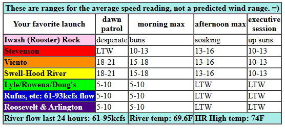
Friday morning started windy thanks to pressures of 30.22/30.13/30.12 for gradients of 0.09/0.01. While there weren’t clouds in the metro area, there were a few marine clouds lodged in the gullet of the Gorge. We’ll see 18-21mph wind from Viento to Hood River for a couple hours this morning. Models suggest the wind will diminish as the day progresses: by afternoon, we’re looking at just 11-14mph from Stevenson to Hood River with less wind to the east. Get it while you can! River flow over the last 24 hours was 61-95kcfs, river temp is 69.6F, and high temp forecast is 74F for Hood River.
RIVER FLOW FOR SITES BETWEEN AVERY (EAST OF THE DALLES) AND RUFUS: CLICK HERE FOR JOHN DAY DAM FLOW.
RIVER FLOW FOR SITES BETWEEN STEVENSON AND DOUG’S BEACH (WEST OF THE DALLES): CLICK HERE FOR THE DALLES DAM FLOW

tomorrow’s gorge wind forecast
Saturday kicks off with east wind thanks to a warm start on the west side. The temp gradient reverses in the afternoon and so does the wind. Expect 20mph easterlies to start the day at both Iwash (Rooster) Rock and Stevenson with 15-20mph at Viento. This only lasts a couple of hours; get it early. The wind turns light/variable midday and then westerly in the afternoon: 15-18mph from Stevenson to Doug’s after 2pm. High temp: 80F.
extended Gorge wind forecast
Very little temp gradient is forecast on Sunday, but a low approaching the coast in the afternoon may give a little nudge to the wind. As of right now, we’re expecting a 14-17mph start form Viento to the Hatch with Stevenson joining midday. Afternoon wind drops to 11-14mph from Stevenson to Hood River as a weather system approaches, and then wind rises to gusty 17-20mph from Mosier to Rufus. High temp: 78F. Cooler, wetter weather is forecast Monday through Wednesday with little to no sign of wind at 17-20mph or more. But hey, it’s going to rain, and we like that!
Was that helpful? I knew it was! Guess what? All of this crucial work – from your personal wind and snow reports to the invaluable TATAS updates – is made possible by my relentless efforts. Maintaining this labor of love isn’t easy. Each daily forecast takes hours. Website hosting, weather model access, and back-end admin work takes time and money. That’s where you come in.
YOUR CONTRIBUTION MAKES A DIFFERENCE
- SUPPORT ACCURATE, HYPER-LOCAL WEATHER FORECASTING
- ENABLE ACCESS FOR ALL, EVEN THOSE WITH LESS MEANS
- SUPPORT A COOL HUMAN WHO WORKS HARD SO YOU CAN PLAY
Take a moment to click one of the buttons below. Donate $19.99 or more (how much does this forecast enhance your life?) and get the email in your inbox. Whether it’s a renewing subscription (auto-renew) or a one-time donation, every contribution makes a real difference. Help me keep this labor of love alive, so we can all continue playing, commuting, and living in the Gorge with peace of mind and the best weather forecasts possible. Thank you!


Hood River, Oregon 97031


JONES BEACH, SAUVIE ISLAND, & COAST FORECAST
Wind northerly unless otherwise indicated. For coast, it’s North/Central/South with the “central” at approximately Florence. Swell forecast from NWS for central coast. Jones: westerly unless otherwise stated. Sauvie Island: northerly unless otherwise stated. Coast Friday: LTV/N1-15/30, W swell 6′ at 15 seconds. Saturday: LTV/LTNW/N25, W 8′ @ 14. Sunday: S20/SSW15-20/S20-25, W 7′ @ 12. Jones Friday: LTW. Saturday: 14-17. Sunday: LTW. Sauvie Island Friday: LTN. Saturday: 9-12. Sunday: LTS.
BARE BONES HOOD RIVER WEATHER FORECAST
Partly cloudy sky this morning. Clear later. Temps start in the mid 50s and rise to the mid 70s. Moderate westerlies. No rainbows. Saturday will be mostly clear with a few high clouds. Temps start in the upper 40s and rise to 80. Light easterlies in the morning. Moderate westerlies in the afternoon. No rainbows. Sunday will be partly high overcast then high overcast. Temps start in the low 50s and rise to the upper 70s. Moderate westerlies. No rainbows.
TEMIRA’S AWESOME TRAVEL ADVISORY SERVICE – FRIDAY
HYPERLOCAL WEATHER FORECAST FOR THE COLUMBIA GORGE
THE DALLES, HOOD RIVER, WHITE SALMON, TROUT LAKE, STEVENSON, CASCADE LOCKS, PARKDALE, ODELL, HUSUM, BZ, MILL A, WILLARD, GOLDENDALE, RUFUS, ARLINGTON, boardman
Good morning, neighbors! There’s honest-to-goodness rain in the forecast next week, for which we’ll be thanking the start and the baby goats and all the other good things in the world. Been waiting for cooler weather? It’s on tap too: highs next week may not even reach 70 degrees some days!
Glenwood this morning
But first… a warm weekend. And before we discuss that, let’s say hi to Glenwood. This morning in Glenwood, as expected, the low was 31 degrees. Folks are nodding their heads and sharing knowing smiles as this first touch of winter-like cold has its way with the pepper and tomato plants. Don’t worry: the “winter-like cold” asked for consent before having its way with the shrubbery. Consent is a cool thing: active consent, asking before doing, and only proceeding if you get a “fuck yeah” in response, is a sexy thing. You should stop reading this forecast and go try it out.
Today’s Gorge weather forecast
For the rest of today, once you’re done with sexy time, we’ll have plenty of sun. A few high clouds this morning (PRETTY SUNRISE!) give way to clear sky later. Temps max out in the mid 70s (west and east) and upper 70s (The Dalles; Dallesport; Dallas, OR; Dallas Texas; Dulles Airport, and all other places with a capital D and a couple of the letter “l”). West wind will be 20-25mph briefly between Viento and the White Salmon Bridge this morning before fading to 15mph mid-morning. The wind drops to 10-15mph this afternoon (only from Stevenson to Hood River – lighter to the east). This makes the boardheads sad, but the boardheads will be okay because yesterday was very wind.
Speaking of yesterday: we all did a very good job with sparks and flames. There was a 0.1 acre fire near Carson that was quickly extinguished. No other fires started in the Gorge yesterday, according to WatchDuty, at least.
Saturday’s Gorge weather forecast
On to tomorrow: partly high cloudy and warm. After a chilly start – 40s in many places – temps rise to 80-85 degrees, warmest in The Dalles, which stays hot as hell for as long as it possibly can. Saturday’s morning wind: east 20mph at Iwash (wanker) Rock, Stevenson, and potentially Viento with light wind to the east. Afternoon wind turns westerlies at 15-20mph between Stevenson and Mosier or maybe Murdoch.
Sunday’s Gorge weather forecast
Sunday’s start will be in the 50-55 range most places with enough high clouds for a pretty sunrise. I know this, because my notes say “SUNRISE”. Clouds increase during the day ahead of an incoming system slated to make land early Monday. Sundays temps max out at 78-83F. West wind will be 15mph or so between Stevenson and Mosier in the morning and from Stevenson to Rufus in the afternoon.
Extended Gorge weather forecast
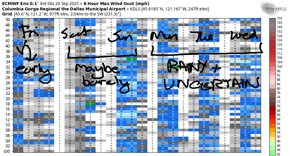
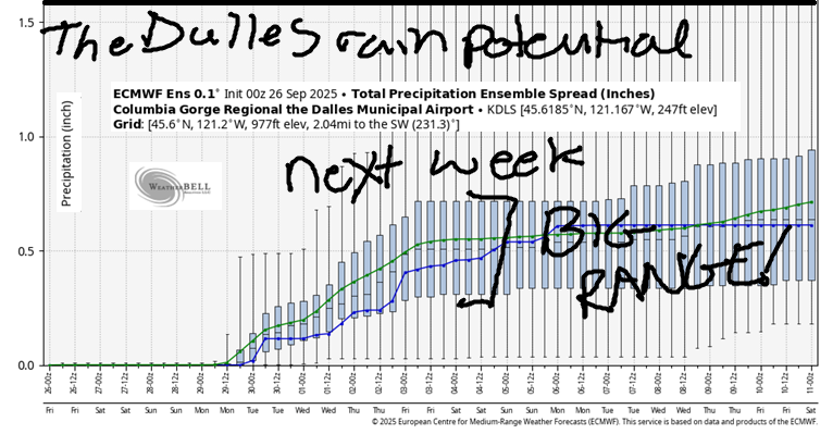
Light rain is forecast on Monday morning as far east as Rowena down low and Centerville up high. Snow level: 9000′. A wetter system arrives on Tuesday with more widespread rain. Snow level: 8000′ falling to 6500′. Even cooler weather, but less moisture, is forecast on Wednesday when the snow level falls to 5500′ and high emps range from the low 60s to the upper 60s. Yay, rain. I’ll dive deeper into the rain details as we get closer – there’s still a huge amount of range in the rain possibilities. Safe travels. -TATAS
HEY! DON’T STOP READING! Is this community-focused forecast helpful to you? It sure is! It takes me a couple hours a day to write. Please join your friends and neighbors in contributing to keep it going. Venmo: @thegorgeismygym PayPal: twomirrors@gmail.com USPS: Temira / PO Box 841 / Hood River, Oregon 97031 You can test out the forecast subscription for a few days for free by signing up below. Easy! Do it!
MT HOOD SNOW FORECAST

CURRENTLY ON VACATION. WILL RETURN SOMETIME BEFORE THE START OF SKI SEASON AT MEADOWS, TIMBERLINE AND SKIBOWL. SAME GOES FOR THE NORDIC SKIING SEASON AT MEADOWS AND TEACUP!
