

GORGE WIND FORECAST
today’s gorge wind forecast
Hi friends! It was so fun to play with you on the river yesterday! It’s Saturday, and today’s Gorge wind forecast is for another round of westerlies. This one likely requires a bit of driving for the most consistent wind. Westerlies continue on Sunday, and then we enter a two-day recovery period before another round of westerlies on Wednesday.
Let’s dive in to today’s forecast. 6am pressures were 30.09/29.95/29.88 with lingering clouds from yesterday’s front and support from an offshore high based near California. An incoming system well offshore stirs things up this afternoon and decreases quality. Intermittent drizzle is likely EAST of The Dalles into early afternoon. Today’s probable focus for strongest wind: Mosier to Rufus.
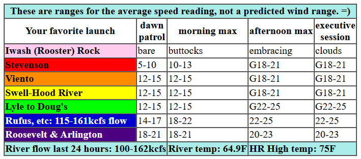
All that said… we started the day with westerlies in the teens to low 20s under the clouds and mid 20s near Rufus with teens farther east. For the morning, we’ll have clouds on the west side with 17-20 from Stevenson to Viento, gusty 14-17 from Swell to Mosier (a short period of 17-21 is possible), and 22-25 from Lyle to Rufus. For the afternoon, the Stevenson to Hood River zone will be gusty 16-20ish. From Mosier (or maybe Lyle) to Rufus, westerlies rise to 27-31. Arlington may also join at that pace, but it may also be in the 23-26 range along with Threemile. Remember that those eastern Gorge sensors read high compared to Swell – 23-26 out there is like 19-22 at Swell. River flow over the last 24 hours was 210-253kcfs, river temp is 54.5F, and high temp forecast is 61F at both Hood River and Arlington.
RIVER FLOW FOR SITES BETWEEN AVERY (EAST OF THE DALLES) AND RUFUS: CLICK HERE FOR JOHN DAY DAM FLOW.
RIVER FLOW FOR SITES BETWEEN STEVENSON AND DOUG’S BEACH (WEST OF THE DALLES): CLICK HERE FOR THE DALLES DAM FLOW

tomorrow’s gorge wind forecast
A warming trend begins on Saturday and continues through Monday, but we’ll hold on to westerlies Saturday. The day starts with 11-14 from Stevenson to Hood River with marine clouds west of Hood River. This gives the desert a jump on heating over the west side, and that’s what gives us our wind. By late morning, we’ll have 17-20 from Stevenson to Hood river with 14-17 at Mosier. Afternoon wind rise to 20-23 from Stevenson to Doug’s with 14-17 at Avery. If Portland clears quickly, Swell-Hood River will drop off to 15-18mph in the afternoon. If the clouds linger, that stretch of river will hold at 20-23mph. High temp: 80F for Hood River (sunny) and 88F for Arlington (mostly clear).
extended Gorge wind forecast
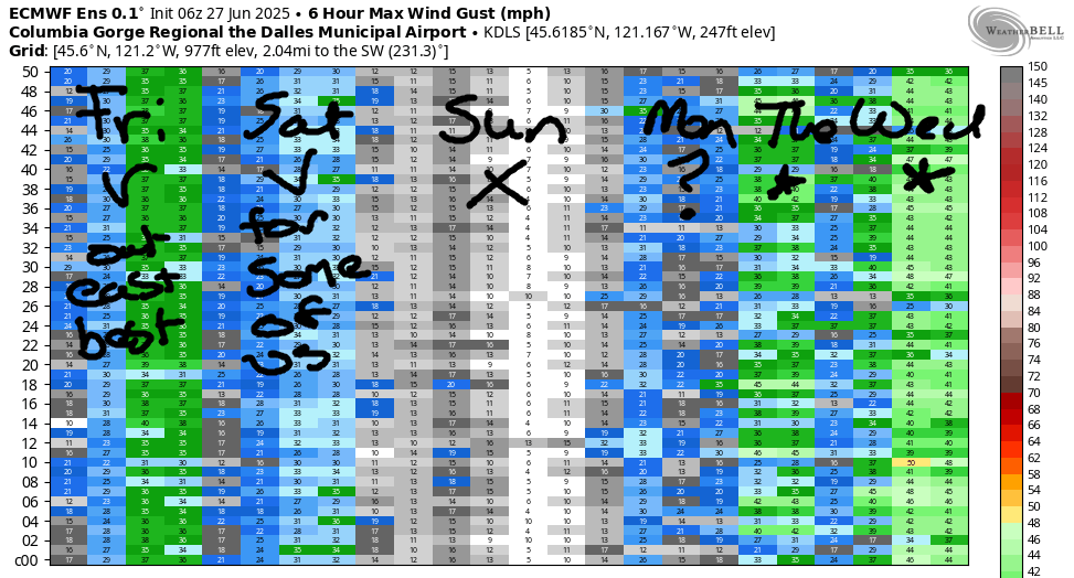
A ridge of high pressure builds over the Pacific Northwest on Sunday, temps soar, and the wind turns easterly. Expect calm wind early in the morning. This is followed by E 10-13mph between Stevenson and Viento midday. Afternoon wind turns calm again. High temp: 90F for Hood River and sunny. Heat lingers on Monday. Depending on when cooler air starts to filter into Portland, we could see a late-day push of quickly building westerlies. It’ll take some luck. The more likely scenario is westerlies that build after the sun goes down. Instability is also a possibility on Monday – if we end up with thunderstorms, all bets are off on the wind.
Triple-digit heat lingers in the desert on Tuesday, and much cooler air settles along the coast and metro area. There’s quite a bit of range in the possible outcomes, but as of now, this looks like The Cooldown You Were Looking For: 30+ MPH in the corridor. Ditto on Wednesday, but the likely focus is Lyle to Rufus. After that? More days of west wind. Looks like a great week. See you on the Nch’i Wana!
JONES BEACH, SAUVIE ISLAND, & COAST FORECAST
Wind northerly unless otherwise indicated. For coast, it’s North/Central/South with the “central” at approximately Florence. Swell forecast from NWS for central coast. Jones: westerly unless otherwise stated. Sauvie Island: northerly unless otherwise stated. Friday: LTW/LTNW/N20-25, W swell 3′ at 9 seconds. Saturday: 15-20/20/30-35+, NW 5′ @ 9. Sunday: 25-30/20-25/30-35, W 5′ @ 10. Jones Friday: LTW. Saturday: 12-15. Sunday: 11-14. Sauvie Island Friday: 11-14. Saturday: 11-14. Sunday: 20-23.
BARE BONES HOOD RIVER WEATHER FORECAST
Clouds this morning and partly cloudy later. Temps start near 60 and rise to the mid 70s. Moderate westerlies. No rainbows. Saturday will be partly cloudy then clear. Temps start in the mid 50s and rise to 80. Moderate westerlies. No rainbows. Sunday will be sunny. Temps start in the mid 50s and rise to 90. Calm wind. No rainbows.
TEMIRA’S AWESOME TRAVEL ADVISORY SERVICE – FRIDAY 6/27
HYPERLOCAL WEATHER FORECAST FOR THE COLUMBIA GORGE
THE DALLES, HOOD RIVER, WHITE SALMON, TROUT LAKE, STEVENSON, CASCADE LOCKS, PARKDALE, ODELL, HUSUM, BZ, MILL A, WILLARD, GOLDENDALE, RUFUS, ARLINGTON, boardman
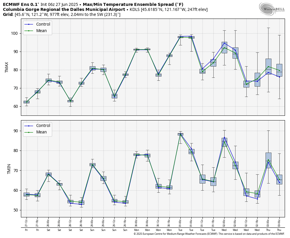
Good morning, neighbors! Cool weather today gives way to building heat over the next several days. By Sunday, we’ll be well into the 90s, and it’s possible we’ll hit triple digits on Monday. Temps fall after that – this isn’t an extended heat wave – but the weather does look warm and summery next week. And windy.
gLENWOOD’S START AND TODAY’S GORGE WEATHER FORECAST
But first, let’s take a look at today. It’s Friday, and Glenwood started off at 56 degrees this morning, a perfectly reasonable way to start the day. West side clouds linger into the afternoon before partially dissipating. East of The Dalles, a sunny start stays mostly sunny all day. High temps range from the mid 70s (west) to 80 (The Dalles) and mid 80s (out in the watermelon-growing zones). Wind will be out of the west (duh – it’s summer) at 10-15mph this morning and 20-25mph this afternoon all the way from Stevenson to the Arlington Triangle, where all shapes including squares, pentagons, rectangles, and parallelograms, have only three sides and are actually triangles. Equilateral triangles. Arlington is a strange place…
SATURDAY’S GORGE WEATHER FORECAST
High temps start stair-stepping upwards on Saturday. Since degrees don’t like exercise, they’ll take this particular StairMaster very slowly: 5-10 degrees a day. Saturday’s temps start cold enough for you to open the windows and doors and cool down your home: 55 degrees or so. Afternoon temps rise to 80 (west) and 88 (The Dalles and everywhere to the east). Wind will be 10-15mph from Stevenson to Hood river to start with less than 10mph east of there. Afternoon wind rise to 15-25mph from Stevenson to Avery with lighter wind to the east.
SUNDAY’S GORGE WEATHER FORECAST
If you’ve been waiting for a break from the west wind, you’ll get it on Sunday, yay! Expect calm wind early and calm wind late with light easterlies midday. Strongest wind will be near Stevenson midday at E 10-15mph. But that’s not even very strong! We’ll have sunshine all day long on Sunday with low temps in the mid 50s and highs from 90 (west) to 95 (east).
EXTENDED GORGE WEATHER FORECAST
There’s quite the range in high temps on Monday. That’s because we don’t yet know how much weed Ma Nature will smoke, so we don’t know how high she”ll get. As of now, models are suggesting we’ll be somewhere in the upper 90s on Monday with a shot at 100F from The Dalles eastward. Models also hint at monsoonal moisture potentially coming for us too. That would be… unpleasant. Muggy. Add in a slight chance of thunderstorms on Monday afternoon. For most of the day, there won’t be any wind. Depending on Ma Nature’s timing (if she’s super-stoned, it’ll be slower), we could see a cooling west wind return late in the day.
If that doesn’t happen Monday before sunset, it’ll happen by Tuesday morning, and that’ll leave us with a hot, muggy start followed by a less-hot-than-Monday finish. Maybe 85-90 degrees for The Dalles and super-strong west wind. Strong westerlies and 80 degree weather sticks around for Wednesday. Fire danger will be off the charts Tuesday and Wednesday thanks to the combo of heat and wind. If you’re in a zone prone to wildfires, consider taking preparatory steps between now and then to protect yourself. Also, consider tossing a fire extinguisher/water/shovel in your car in case you encounter a just-started fire; a nice local citizen put one out between Bingen and Lyle a few days ago with her car fire extinguisher. You too could be that kind of hero. Safe travels. -TATAS
HEY! DON’T STOP READING! Is this community-focused forecast helpful to you? It sure is! It takes me a couple hours a day to write. Please join your friends and neighbors in contributing to keep it going. Venmo: @thegorgeismygym PayPal: twomirrors@gmail.com USPS: Temira / PO Box 841 / Hood River, Oregon 97031 You can test out the forecast subscription for a few days for free by signing up below. Easy! Do it!
