

GORGE WIND FORECAST
If you’re still seeing yesterday’s and it’s after 9am, try opening this in an incognito window
today’s gorge wind forecast
Hi friends! Yesterday was a wild one – chaotic water, gusty wind, a slalom course of weed patches… And the fun will continue today as heat ramps up in the desert and draws the wind through the Gorge. Moderately strong to strong westerlies are in the cards all the way through Monday. While we do have some moving parts (in particular instability) the overall picture looks good.
First things first: the Hood River Bridge is closed between 11am and 1pm today for a lift for marine traffic. Next, there are sailboat races Saturday and Sunday between the Hood River Marina and the buoy below the Hatchery. Consider recreating somewhere else those days. If you can’t, please give way to the racers!
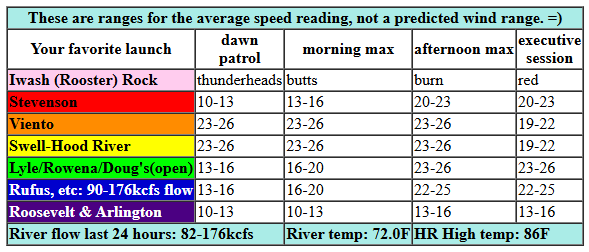
Let’s take a look at Friday, shall we? I see big whitecaps in front of my house. Pressures at 7am were 30.16/30.03/30.01 for gradients of 0.13 (PDX-DLS) and 0.02 (DLS-PSC). Westerlies for TJ’s Dawn Patrol were averaging 22-25mph between Viento and the Hatch with 13-16mph at Stevenson, the Rowena Stretch, Rufus, and even out at Arlington. The wind picks up to 23-26mph from Viento to Mosier this morning and fills in at 20-23mph at Stevenson. Afternoon: westerlies hold at Swell and fill in at 23-26mph from Stevenson to Avery. Rufus eventually joins at 22-25mph mid afternoon, and Swell falls to 19-22mph as the metro area heats up under clearing sky.
River flow over the last 24 hours was 82-176kcfs (90-176kcfs at Rufus), river temp is 72.0F (poor salmon), and high temp forecast is 86F in Hood River and 92F out in the desert. Note: thunderstorms continue to be possible east of the Cascade Crest (east of Doug’s), so be prepared for the possibility of very unreliable desert wind today. Note: wind speed forecasts are to the iWind/iKite sensors. The Swell sensor reads low compared to sensors east of The Dalles. In other words, 25mph at Swell and 25mph at Rufus are not the same – 30mph at Rufus is approximately equal to 19-23mph (average) at Swell. Hope that helps!
RIVER FLOW FOR SITES BETWEEN AVERY (EAST OF THE DALLES) AND RUFUS: CLICK HERE FOR JOHN DAY DAM FLOW.
RIVER FLOW FOR SITES BETWEEN STEVENSON AND DOUG’S BEACH (WEST OF THE DALLES): CLICK HERE FOR THE DALLES DAM FLOW

tomorrow’s gorge wind forecast
Low clouds slide into the metro area tonight and set us up for another windy day Saturday. Out in the desert, it’ll be hotter and more stable than on Saturday. All this bodes well! Dawn patrol starts with 22-25mph from Viento to Mosier with 14-17mph east of Mosier to Arlington. By early afternoon, we’ll have 24-27mph from Stevenson to Doug’s with 14-17mph at Rufus. Rufus eventually joins in the mid 20s. High temp: 84F in Hood River and 92F at Rufus.
extended Gorge wind forecast
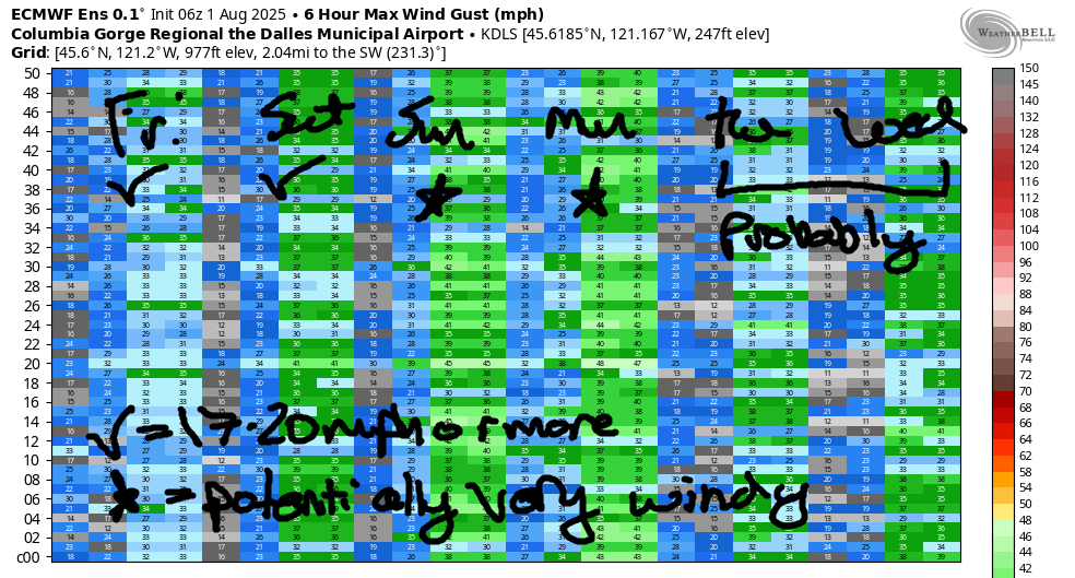
Lots of moving pieces are forecast for Sunday, but the GFS and the Euro ensembles both have a big day. Thunderstorms are possible out east, which means the wind will likely be gusty and unreliable out there. That said… models give us 23-26mph at Swell to start, 26-29mph midday, and 28-33mph from Swell (or maybe Moiser if the metro area heats too much) to Rufus in the afternoon. Fingers crossed! A very solid marine layer is forecast on Monday. The exact location of the strongest wind depends on where that cloud line sets up and how far east the cool air extends. Ensembles knock the wind down a bit on Tuesday and Wednesday, but we’ll almost certainly see 17-20mph or more through Thursday. After that: too much uncertainty to make a call. Sounds like a darn fine stretch of wind, doesn’t it? Be safe out there. See ya on the Nch’i Wana!
Was that helpful? I knew it was! Guess what? All of this crucial work – from your personal wind and snow reports to the invaluable TATAS updates – is made possible by my relentless efforts. Maintaining this labor of love isn’t easy. Each daily forecast takes hours. Website hosting, weather model access, and back-end admin work takes time and money. That’s where you come in.
YOUR CONTRIBUTION MAKES A DIFFERENCE
- SUPPORT ACCURATE, HYPER-LOCAL WEATHER FORECASTING
- ENABLE ACCESS FOR ALL, EVEN THOSE WITH LESS MEANS
- SUPPORT A COOL HUMAN WHO WORKS HARD SO YOU CAN PLAY
Take a moment to click one of the buttons below. Donate $19.99 or more (how much does this forecast enhance your life?) and get the email in your inbox. Whether it’s a renewing subscription (auto-renew) or a one-time donation, every contribution makes a real difference. Help me keep this labor of love alive, so we can all continue playing, commuting, and living in the Gorge with peace of mind and the best weather forecasts possible. Thank you!


Hood River, Oregon 97031


JONES BEACH, SAUVIE ISLAND, & COAST FORECAST
Wind northerly unless otherwise indicated. For coast, it’s North/Central/South with the “central” at approximately Florence. Swell forecast from NWS for central coast. Jones: westerly unless otherwise stated. Sauvie Island: northerly unless otherwise stated. Coast Friday: 10-15/15-20/25-30, W swell 2′ at 7 seconds. Saturday: 15/15/25-30, W 2′ @ 7. Sunday: 15/10/20, W 3′ @ 7. Jones Friday: 17-20. Saturday: 22-25. Sunday: 16-19. Sauvie Island Friday: 11-14. Saturday: 11-14. Sunday: 12-15.
BARE BONES HOOD RIVER WEATHER FORECAST
Friday will be cloudy then mostly clear. Temps start in the upper 60s and rise to the mid 80s. Moderately strong westerlies. No rainbows. Saturday will start mostly clear and end clear. Temps start near 60 and end in the mid 80s. Strong westerlies. No rainbows. Sunday will be partly cloudy then mostly clear. Temps start near 60 and rise to the upper 70s. Strong westerlies. No rainbows.
TEMIRA’S AWESOME TRAVEL ADVISORY SERVICE
HYPERLOCAL WEATHER FORECAST FOR THE COLUMBIA GORGE
THE DALLES, HOOD RIVER, WHITE SALMON, TROUT LAKE, STEVENSON, CASCADE LOCKS, PARKDALE, ODELL, HUSUM, BZ, MILL A, WILLARD, GOLDENDALE, RUFUS, ARLINGTON, boardman
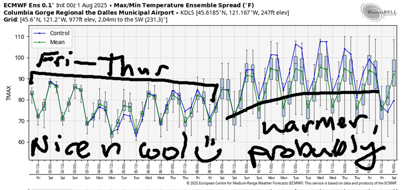
Good morning, neighbors! A six-day stretch of relatively cool (for here, for summer, anyway) weather is on tap. Along with the heat-relief comes the wind: strong westerlies day after day for locations west of John Day Damn and sometimes to the east as well. Thunderstorm chances linger on Friday and on Sunday and maybe on Monday too.
today’s gorge weather forecast and glenwood and some other stuff
Before I forget, and before you forget… the Decrepit Old Bridge (DOB), aka the Hood River Bridge, will close from 11am to 1pm today to lift the span for a vessel. They didn’t specify what kind of vessel, but I’m hoping it’s a magic lamp that contains an all-powerful genie that will grant us a wish that we can use to get funding for a new and toll-free bridge. Fingers crossed! Oh gosh… almost forgot Glenwood! It was 51 degrees there this morning, just warm enough to wrangle some cows sans pants.
Weather for this lifting of the lift span … wait, if it’s a lift span bridge, why do the signs say “Draw Bridge” and “Drawbridge Ahead”? And why do they want us to draw the bridge while we’re driving? That doesn’t seem safe! Anyway, weather will be overcast this morning and sunny later. In the desert: a mix of clouds all day. Temps rise to the mid 80s on the west side and low to mid 90s to the east. West wind: 25mph all day from Stevenson to Mosier and 25mph in the afternoon from Stevenson to Bob’s Texas T-Bone, the location known on maps as “The Rufus of America” but also known for steaks. Tonight should be a good night for sleeping, as temps will cool off to 60ish in many locations.
saturday’s gorge weather forecast
Saturday kicks off with some low clouds west of Hood River and just a few little fluffy clouds to the east. I only say “little fluffy clouds” so I have an excuse to listen to The Orb before 9am. Now you’re seeing the World In My Eyes. By Saturday afternoon, we’ll all be sunny and warm: 85 degrees to the west, 90 in The Dalles, and upper 90s out where the watermelons are growing and being harvested. West wind starts at 20-25mph between Viento and Mosier and rise to 25-30mph between Stevenson and Bob’s Texas T-Bone and Frosty’s Lounge.
sunday’s gorge weather forecast
Models suggest the possibility of thunderstorms in the desert on Sunday. They also call for very strong west wind: 25-30mph on the west side and 30-35mph east of Rowena. High temps finish up in the upper 70s (PERFECTION) on the west side, mid 80s near The Dalles (downright chilly for that location this time of year) and low 90s in the desert (warm enough for sugar-sweet watermelons). Monday looks even cooler and also quite windy especially east of The Dalles. In addition, models hint at another round of thunderstorms and perhaps some rain. That would be amazing.
extended gorge weather forecast
Cool weather continues at least through Thursday – models are in good agreement about that. Starting next Friday, uncertainty multiplies like rabbits bumping uglies on a hillside in spring. It’s likely next weekend will be warmer – it’s just a matter of how warm it will get. The intensity of the warmth depends on how many rabbits bump uglies between now and then. Actually, it depends on how much ugly-bumpin’ happens across all species between now and then. Note: I did not say “between” species. So, if you take a vow of celibacy for the next week, next weekend will be nice and cool. Safe travels. -TATAS
HEY! DON’T STOP READING! Is this community-focused forecast helpful to you? It sure is! It takes me a couple hours a day to write. Please join your friends and neighbors in contributing to keep it going. Venmo: @thegorgeismygym PayPal: twomirrors@gmail.com USPS: Temira / PO Box 841 / Hood River, Oregon 97031 You can test out the forecast subscription for a few days for free by signing up below. Easy! Do it!
