

GORGE WIND FORECAST
If you’re still seeing yesterday’s and it’s after 9am, try opening this in an incognito window
today’s gorge wind forecast
Hi friends! As you might have guessed by this morning’s cloud cover, the overall pattern has shifted. This knocks down the wind speed for the next several days. For those of you who like your wind in the 15-20mph range, you’ll get what you’re looking for. Those of you who like big days will be waiting a while… until the next warming-cooldown cycle… maybe next weekend? Before I forget… this weekend is the Gorge Challenge. Lots of events happening including downwind racing. This is all based out of Viento and the Hood River Waterfront.
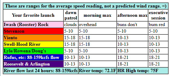
Friday started off with clouds way out into the desert. Pressures at 8am were 29.94/29.91/29.90 for gradients of 0.03 (PDX-DLS) and 0.01 (DLS-PSC). Despite this lack of support, the Viento-Swell zone was reading 15-18mph as I was writing this. With cool air extending into the desert, we won’t have much thermal support today. A front swinging through and another one approaching is all we have to drive the wind. Areas west of The Dalles are likely to drop to 10-13mph or less pretty quickly. Between Avery and Arlington, we should see 18-21mph after 2pm. Remember that 18-21mph on those eastern Gorge sensors is not equivalent to 18-21mph at Swell; it’s more like 14-17mph. River flow over the last 24 hours was 88-159kcfs, river temp is 71.2F, and high temp forecast is 75F for Hood River and low 80s out near Rufus.
RIVER FLOW FOR SITES BETWEEN AVERY (EAST OF THE DALLES) AND RUFUS: CLICK HERE FOR JOHN DAY DAM FLOW.
RIVER FLOW FOR SITES BETWEEN STEVENSON AND DOUG’S BEACH (WEST OF THE DALLES): CLICK HERE FOR THE DALLES DAM FLOW

tomorrow’s gorge wind forecast
Light wind and steady rain start out our Saturday. Once the weather system moves through, westerlies pick up a bit. Light wind continues through early afternoon west of The Dalles. Models have Avery to Rufus at 14-17mph mid-morning. As the system swings through in the afternoon, you can chase the cloud line east for a bit more wind: 15-18mph from Stevenson to Mosier and (eventually) 20-23mph from Avery to Rufus (probably after 5pm). High temp: 76F on the west side and low 80s out east.
extended Gorge wind forecast
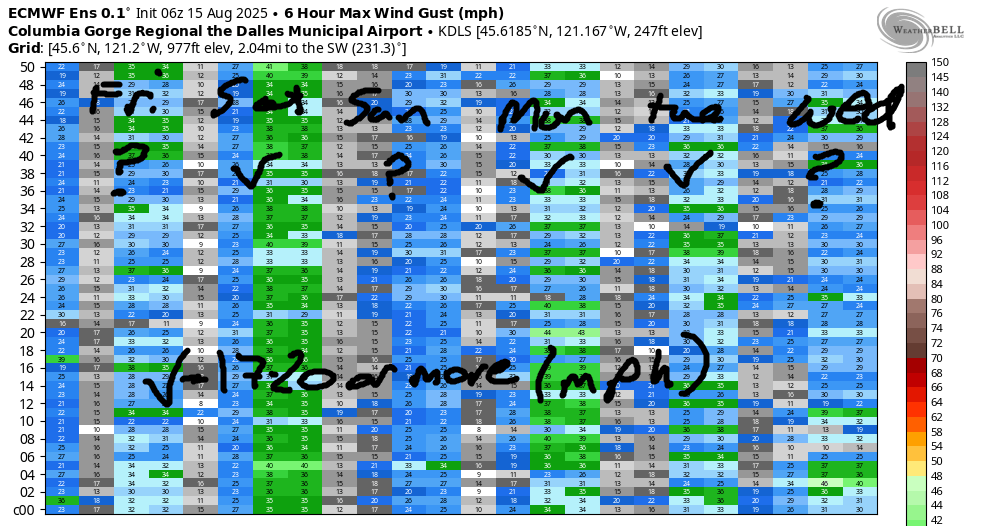
Sunshine returns to the desert on Sunday, and this gives us a more “normal” wind setup. The day starts with 13-16mph from Viento to Swell. Afternoon: 17-20mph from Stevenson to Rufus. High temp: upper 70s to low 80s. Slightly stronger wind is forecast for Monday and Tuesday, but there’s a lot of range in the possibilities. Wednesday has a good shot at reaching 17-20mph. As we look deeper into the future, models struggle with the placement of a ridge (and associated warm-to-hot temps). Models suggest stronger onshore gradients will return sometime in the Saturday to Tuesday time frame (8/24 on). But hey, that’s nine days out and very, very uncertain. Between now and then, take the time to work on your lighter-wind skills. See you on the Nch’i Wana!
Was that helpful? I knew it was! Guess what? All of this crucial work – from your personal wind and snow reports to the invaluable TATAS updates – is made possible by my relentless efforts. Maintaining this labor of love isn’t easy. Each daily forecast takes hours. Website hosting, weather model access, and back-end admin work takes time and money. That’s where you come in.
YOUR CONTRIBUTION MAKES A DIFFERENCE
- SUPPORT ACCURATE, HYPER-LOCAL WEATHER FORECASTING
- ENABLE ACCESS FOR ALL, EVEN THOSE WITH LESS MEANS
- SUPPORT A COOL HUMAN WHO WORKS HARD SO YOU CAN PLAY
Take a moment to click one of the buttons below. Donate $19.99 or more (how much does this forecast enhance your life?) and get the email in your inbox. Whether it’s a renewing subscription (auto-renew) or a one-time donation, every contribution makes a real difference. Help me keep this labor of love alive, so we can all continue playing, commuting, and living in the Gorge with peace of mind and the best weather forecasts possible. Thank you!


Hood River, Oregon 97031


JONES BEACH, SAUVIE ISLAND, & COAST FORECAST
Wind northerly unless otherwise indicated. For coast, it’s North/Central/South with the “central” at approximately Florence. Swell forecast from NWS for central coast. Jones: westerly unless otherwise stated. Sauvie Island: northerly unless otherwise stated. Coast Friday: S25/SS@20/LTV, SW swell 2′ at 14 seconds. Saturday: LTW/LTW/N10-15, W 7′ @ 10 and SW 2′ @ 14. Sunday: LTNW/LTNW/NW10, W 6′ @ 10. Jones Friday: LTW. Saturday: LTW. Sunday: LTW. Sauvie Island Friday: S 5-10. Saturday: LTNNW. Sunday: LTV.
BARE BONES HOOD RIVER WEATHER FORECAST
Clouds all day. Rain tonight. Temps start in the mid 60s and rise to the mid 70s. Light westerlies. 57% chance of rainbows. Saturday will be rainy then partly cloudy. Temps start in the low 60s and rise to the mid 70s. Light westerlies in the morning. Moderate later. 98% chance of rainbows. Sunday will be cloudy then high overcast. Temps star tint he mid 50s and rise to the upper 70s. Moderate westerlies. No rainbows.
TEMIRA’S AWESOME TRAVEL ADVISORY SERVICE – FRIDAY 8/15
HYPERLOCAL WEATHER FORECAST FOR THE COLUMBIA GORGE
THE DALLES, HOOD RIVER, WHITE SALMON, TROUT LAKE, STEVENSON, CASCADE LOCKS, PARKDALE, ODELL, HUSUM, BZ, MILL A, WILLARD, GOLDENDALE, RUFUS, ARLINGTON, boardman
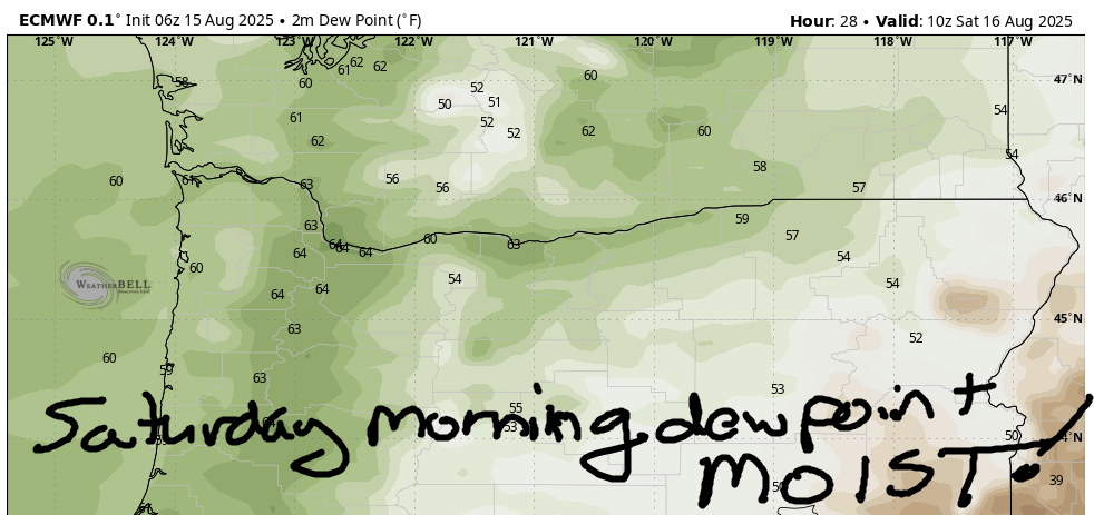
Good morning, neighbors! Just a touch of rain last night leaves us with a cloudy day today. Heavier rain is forecast tonight, but models still have quite a bit of range in how much rain will fall. They’re clear about one thing: we’re in for a muggy couple of days! After Saturday, the weather turns dry, but temps stay right around average. That’s pleasantly cool compared to the last few summers, which were mostly hotter than average on a day-to-day basis. Models hint at warmer weather by next weekend, but they aren’t calling for any sort of extreme heat. Just enough warmth to nudge the rainbow chanterelles above the duff.
GLENWOOD THIS MORNING AND TODAY’S GORGE WEATHER FORECAST
Friday started out muggy and warm, even in Glenwood, where it was 61 degrees this morning. I don’t have easy access to Glenwood’s temp records, but I’d put money on that being a record high-low! The unusual warmth led to all the adults in Glenwood stripping naked for coffee hour, and this let to horrified looks from everyone else. Naked people – how embarrassing! The rest of us also started warm. Hood River was a degree or two from setting a record high-low. With clouds sticking around all day, all the way east into the desert, we’ll set no record high-highs. Max temps will be 75F (west), 82F (The Dalles), and 87F (the desert, where everyone is eating watermelons for dessert). West wind will be 15-20mph this morning near Hood River. Afternoon: 10mph west of The Dalles and 20mph east of The Dalles out to the Arlington Triangle-Rhombus. The triangle and Rhombus got married, hence the hyphenated name.
SATURDAY’S GORGE WEATHER FORECAST
Overnight tonight (that’s Friday night if you’ve lost track, and also, the Seahawks are playing at 7pm, which is basically the middle of the night for early risers like me!), we’re expecting rain starting around 11pm. Expect heavy rain west of Wyeth through Saturday morning. Moderate rain extends as far east as The Dalles to start Saturday. The rain pushes all the way to Boardman mid-morning. By noon, areas west of The Dalles will be dry. By 2pm, areas west of Biggs will be dry. By 5pm, everyone west of the Tri-Cities will be dry. Exception: a little lingering drizzle or mist west of Cascade Locks on and off into Sunday morning. Other Saturday news: temps start near 60. They rise to the mid 70s (west) and low 80s (The Dalles eastward). Wind will be light to start. Afternoon: 15-20mph west of The Dalles and 20-25mph east of The Dalles. After a cloudy start, the sky turns partly cloudy west of the Cascade Crest and sunny to the east.
SUNDAY’S GORGE WEATHER FORECAST
Sunday looks like another reasonably pleasant day. 50-something degrees to start. 80-85F degrees to finish. The west side starts cloudy. The east side starts clear. Everyone ends up with sunshine. West wind starts at 10-15mph between Viento and Hood River with light wind elsewhere. Afternoon: 15-20mph from Stevenson to Rufus. Monday, Tuesday, and Wednesday look rather similar to Sunday. We’ll see a slow warming trend – temps on Wednesday will be 85F on the west side and 90F from The Dalles eastward. Beyond that: warming temps into the latter part of the week when models suggest mid 90s for The Dalles. Uncertainty increases starting Saturday, when models hint at some sort of cooling trend. Maybe. Safe travels. -TATAS
HEY! DON’T STOP READING! Is this community-focused forecast helpful to you? It sure is! It takes me a couple hours a day to write. Please join your friends and neighbors in contributing to keep it going. Venmo: @thegorgeismygym PayPal: twomirrors@gmail.com USPS: Temira / PO Box 841 / Hood River, Oregon 97031 You can test out the forecast subscription for a few days for free by signing up below. Easy! Do it!
