

GORGE WIND FORECAST
If you’re still seeing yesterday’s and it’s after 9am, try opening this in an incognito window
today’s gorge wind forecast
Hi friends! Very active weather is planned for the next four days. Best chance of wind in that period is late Saturday when a low moves in to Canada. It’s entirely possible that will happen too late – the strongest wind is almost certain to be after dark – but there’s a chance of a late afternoon west wind session Saturday.
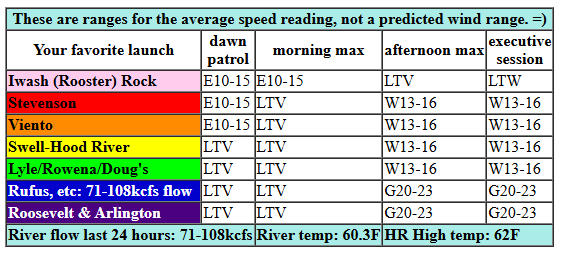
Friday started off with light easterly wind in the 10-15mph range at Iwash, Stevenson, and Viento. That’s all we’ll see this morning. Afternoon sees the wind turn westerly at gusty (and rainy) 13-16mph from Stevenson to The Dalles. After 5pm, we could see gusty 20-23mph from Avery to Arlington just ahead of incoming rain. It’s low-probability and also short duration. River flow over the last 24 hours was 71-108kcfs, river temp is 60.3F, and high temp forecast is 62F.
RIVER FLOW FOR SITES BETWEEN AVERY (EAST OF THE DALLES) AND RUFUS: CLICK HERE FOR JOHN DAY DAM FLOW.
RIVER FLOW FOR SITES BETWEEN STEVENSON AND DOUG’S BEACH (WEST OF THE DALLES): CLICK HERE FOR THE DALLES DAM FLOW

tomorrow’s gorge wind forecast
Saturday starts with east wind at 30mph at Stevenson and 25mph at Iwash (Rooster) Rock. The wind quickly drops to 20-25mph at both those spots and falls even more in early afternoon. Also, it’ll be raining on your east wind party. After 2pm, strong WSW wind arrives, driven in large part by strong upper-level wind. This setup favors Arlington, Threemile, Boardman, and potentially Rufus with 30+mph. But it’s going to happen late, maybe too late; best shot at decent wind is after the rain stops falling in the desert, after 5pm. Another possible option is Viento-Hatch for a short period of very gusty wind late afternoon. High temp: 55F for Hood River and 60F in the desert.
extended Gorge wind forecast
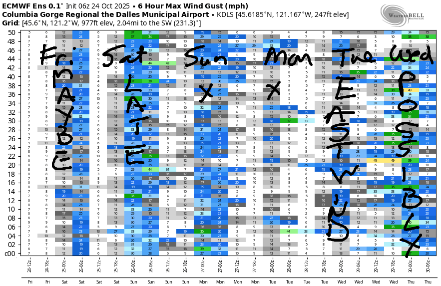
Sunday looks light and variable and wet. Monday brings light easterlies. Another low pressure system approaches the coast on Tuesday and gives us wet, gusty, 25-30mph east wind. If the associated low moves inland in the right spot with the right timing next Wednesday, we’ll have another shot at a big eastern Gorge day. We now turn our attention to other sports: first, there is a HRATS work party in Post on Sunday – meet at 9am at Family Man. Second, there’s almost certain to be enough to snow to play in at Meadows Sunday or Monday. Hopefully that’s enough fun for you despite the poor wind forecast. See you out in the Gorge Gym!
Was that helpful? I knew it was! Guess what? All of this crucial work – from your personal wind and snow reports to the invaluable TATAS updates – is made possible by my relentless efforts. Maintaining this labor of love isn’t easy. Each daily forecast takes hours. Website hosting, weather model access, and back-end admin work takes time and money. That’s where you come in.
YOUR CONTRIBUTION MAKES A DIFFERENCE
- SUPPORT ACCURATE, HYPER-LOCAL WEATHER FORECASTING
- ENABLE ACCESS FOR ALL, EVEN THOSE WITH LESS MEANS
- SUPPORT A COOL HUMAN WHO WORKS HARD SO YOU CAN PLAY
Take a moment to click one of the buttons below. Donate $19.99 or more (how much does this forecast enhance your life?) and get the email in your inbox. Whether it’s a renewing subscription (auto-renew) or a one-time donation, every contribution makes a real difference. Help me keep this labor of love alive, so we can all continue playing, commuting, and living in the Gorge with peace of mind and the best weather forecasts possible. Thank you!


Hood River, Oregon 97031


MT HOOD SNOW FORECAST

Today’s Mt. Hood snow forecast
Hey skiers and snowboarders! First snow forecast of the season! I’m not going to forecast every day, but this weekend is worth a look. It’s Friday, and the snow level this evening will be around 8000′. It falls to 4500′ around midnight and bounces up to 5000′ after midnight. Prior to the dip in snow levels around 11pm, the mountain picks up 0.75” precip, mostly as rain. After 11pm, not much moisture is forecast. Wind this evening will be SW 40 then WSW 25, then SSW 10-15 after midnight.
Saturday’s Mt. Hood snow forecast
Saturday starts cloudy and quickly turns snowy. Yay! The snow level will be 5000′ in the morning, 4000′ late afternoon, and 3500′ after midnight. About 0.5” water equivalent (WE) is forecast during the day for 3-4” at 5000′. Overnight, another 0.6” WE is forecast in the models, but I suspect we’ll double that thanks to very, very strong orographic (terrain-driven) effects. Call it 10-12” new snow at 5000′. Wind: SSSW 10-15 early, WSW 60-65 in the afternoon, W 60 overnight, and W 40 after midnight. That W 60mph is enough for massive buildup of snow on leeward slopes, and it’s also enough to impact snow quality and make windslab and sastrugi!
Sunday-Monday Mt Hood snow forecast
Sunday brings additional snowfall. Snow tapers off overnight. The snow level will be 3000-3500′ all day, and the free air freezing level will drop to 2500′ after midnight. During the day, 0.4” WE is forecast, and strong W/WNW wind will enhance snowfall. Call it another 6” or so. Overnight, another 0.2” WE is forecast for a couple inches more. Wind: W 40 in the morning, WNW 25-30 in the afternoon, and W 15mph after midnight. Monday looks partly cloudy and cool with the free air freezing level around 4000′. I certainly have my eyes on this system as the first opportunity to plod around in the snow and have a snowball fight. Remember that roads will be very snowy and likely not fully maintained. Make sure you’re prepared for winter driving conditions!
BARE BONES HOOD RIVER WEATHER FORECAST
Cloudy this morning. Rainy this afternoon. Temps start in the mid 40s and rise to the low 60s. Light westerlies this morning. Light to moderate later. 23% chance of rainbows. Saturday will be Cloudy and rainy. Temps start in the low 40s and rise to the mid 50s. Light easterlies switching to westerly in the afternoon. 99% chance of rainbows. Snow level 5000′ falling to 3500′. Sunday will be rainy. Temps start near 40 and rise to 50. Light and variable wind. 89% chance of rainbows. Snow level 3500′.
TEMIRA’S AWESOME TRAVEL ADVISORY SERVICE
HYPERLOCAL WEATHER FORECAST FOR THE COLUMBIA GORGE
THE DALLES, HOOD RIVER, WHITE SALMON, TROUT LAKE, STEVENSON, CASCADE LOCKS, PARKDALE, ODELL, HUSUM, BZ, MILL A, WILLARD, GOLDENDALE, RUFUS, ARLINGTON, boardman
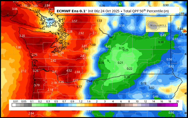
Good morning, neighbors! Any way you slice it, we have a wet weekend on tap. Looking at the Euro 50 percentile rain map, we’ve got anything from 0.29” in the desert to a couple inches near Cascade Locks. WET! Rain starts up midday today (it’s Friday, thank the fucking stars!) and continues on and off mostly of the time all the way through late Sunday night. In this period, we also see our first big snowstorm of the season on the mountain passes and yet another windstorm out in the desert. On Monday morning, frost is likely thanks to partly cloudy sky, light wind, and 850mb temps at -1C.
Whew.
Glenwood this morning
Glenwood is already prepared for chilly weather – they’ve been practicing. This morning saw the temp bottom out at 37F in Glenwood, cold enough for a fire and morning s’mores. As long as you make the marshmallows at home, s’mores are considered healthy. If you’ve never made marshmallows from scratch, I recommend it. Warm marshmallow cream is so, so good!
Today’s Gorge weather forecast
Rest of today: cloudy. Rain starts soon west of Wyeth, makes it to Hood River around 11am, The Dalles shortly after that, Goldendale by 2pm, and the Tri-Cities (all 3 of them) by 5pm. Starting around 2pm, the rain turns very heavy all the way to Hood River, and this heavy rain extends all the way to Arlington in the evening. South Wasco: your rain, moderate in intensity, starts around 5pm. Expect very unpleasant driving conditions on 84/14 starting around 2pm – this high-intensity rain will make for puddles, hydroplaning, and lots of spray off the other vehicles. If you can wait until 8pm, the rain intensity should decrease; we’ll be mostly dry overnight into Saturday morning. Wind today: light easterly this morning. West 15mph west of The Dalles and west 20mph east of The Dalles this afternoon. High temps will be in the low to mid 60s in the lowlands.
Saturday’s Gorge weather forecast
A brief break in the rain through 8am Saturday will be, well, brief. So you should put on your briefs (boxers or otherwise) and go for an early morning run if that’s something your body can do. If not, lounge around drinking coffee in your tightie whities. HOT! Steady rain arrives for everyone west of Lyle by 9am. Rain pushes east to Idaho (including south Wasco and Sherman counties) by 11am. After 5pm, the rain mostly stays west of the Cascade Crest with Goldendale and Centerville likely staying rainy a bit longer. Saturday’s wind starts with E 20-30mph at Iwash (cock) Rock, Stevenson, and Viento with lighter easterlies elsewhere. Sometime mid-afternoon, west wind returns. It’ll very very strong east of Avery or perhaps east of the John Day dam all night long. High temps range from 55F in Hood River to the low 60s from The Dalles eastward. Up in the mountains, the snow level starts Saturday at 5000′ and ends Saturday at 3500′ or so. Very, very strong wind aloft overnight will make for blizzard conditions on the passes. Skip it if you can.
Sunday’s Gorge weather forecast
Showery weather Sunday morning gives way to steady rain west of Mosier all day. In the afternoon, steady rain extends eastward out into the desert. Wind: light and variable. Low temp: low 40s. High temp: low to mid 50s. Snow level: 3000-3500′. Passes: snowy and breezy, but not quite as windy as on Saturday night.
Extended Gorge weather forecast
Things calm down on Monday: partly cloudy sky, light east wind, and a frosty start for our higher elevations that start the day clear. Looking at the rest of next week, we see rain possible Tuesday into Wednesday followed by the potential (65% or so in the Euro ensembles) for a pretty intense atmospheric river with heavy rain next weekend. Halloween: the current forecast is for dry weather east of Cascade Locks into early evening, but that could change. We’ll keep a close eye on that one, for sure. Have you picked up a costume yet? No? I hear inflatable frogs are all the rage this year… Safe travels. -TATAS
HEY! DON’T STOP READING! Is this community-focused forecast helpful to you? It sure is! It takes me a couple hours a day to write. Please join your friends and neighbors in contributing to keep it going. Venmo: @thegorgeismygym PayPal: twomirrors@gmail.com USPS: Temira / PO Box 841 / Hood River, Oregon 97031 You can test out the forecast subscription for a few days for free by signing up below. Easy! Do it!
JONES BEACH, SAUVIE ISLAND, & COAST FORECAST
ON WINTER VACATION
