

GORGE WIND FORECAST
If you’re still seeing yesterday’s and it’s after 9am, try opening this in an incognito window
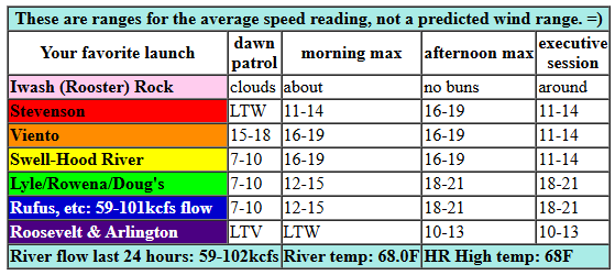
today’s gorge wind forecast
Hi friends! Happy Friday! We’ve got a couple days of moderate westerlies on tap. That’s followed by not-much on Sunday (other than warm, sunny, lovely weather). That’s followed by two days of decent easterlies on Monday and Tuesday. Model uncertainty increases on Wednesday as the overall pattern shifts – the ensembles of the Euro have about a 50% chance of moderately strong westerlies next Wednesday, but there’s still a ton of uncertainty.
Looking at this morning (Friday!), we have early pressures of 30.12/30.07/30.07 and some disagreement between the Euro and the GFS on today’s wind. Part of that, at least, is due to a couple of week systems swinging through (or approaching) in coordination with a weak offshore low. The day starts with 11-14mph from Viento to Swell. By late morning, we should see a period of 16-19mph from Stevenson to Doug’s. The wind drops to 11-14mph west of Mosier mid-afternoon and rises to 18-21mph from Mosier to Rufus. River flow over the last 24 hours was 59-102kcfs, river temp is 68.0F, and high temp forecast is 68F for Hood River and 72F for Rufus.
RIVER FLOW FOR SITES BETWEEN AVERY (EAST OF THE DALLES) AND RUFUS: CLICK HERE FOR JOHN DAY DAM FLOW.
RIVER FLOW FOR SITES BETWEEN STEVENSON AND DOUG’S BEACH (WEST OF THE DALLES): CLICK HERE FOR THE DALLES DAM FLOW

tomorrow’s gorge wind forecast
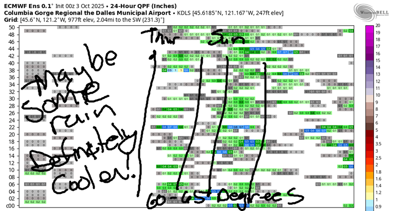
Saturday’s forecast is a bit trickier. The GFS and ECMWF ensembles are far, far apart in their predictions. We’ll have another weather system, a weak one, moving through with a chance of sprinkles late morning into early afternoon. Best guess is 10-13mph for the morning from Viento to Swell. With drizzle forecast west of The Dalles in the afternoon, I’m guessing gusty 11-14mph for that zone. East of The Dalles, gusty 18-22mph for the afternoon seems likely. High temp: 65F for Hood River and 70F at Rufus.
extended Gorge wind forecast
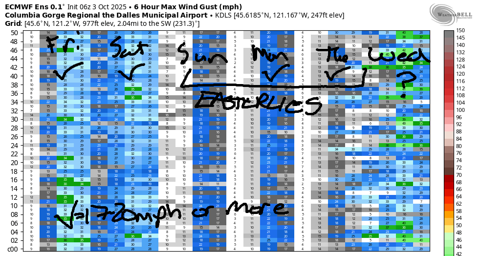
Sunday sees high pressure build inland. Wind turns light easterly, perhaps 15mph max at Stevenson, Home Valley, Viento, and Iwash (Rooster) Rock for a few hours late morning. In the afternoon, the wind drops to 10mph or so. High temp: 68F. Monday brings stronger easterlies, perhaps 25-30mph at Iwash Rock and 25mph at Stevenson. Tuesday currently looks about 5mph stronger. Model agreement falls apart on Wednesday; some member of the ensembles have light wind, and some have moderate to strong westerlies. There’s no way to make a prediction at this point, but it does look like Wednesday is the best shot at stronger west wind in the next week; after that, we fall into a cooler, wetter pattern. Have a great day today. See you on the Nch’i Wana!
Was that helpful? I knew it was! Guess what? All of this crucial work – from your personal wind and snow reports to the invaluable TATAS updates – is made possible by my relentless efforts. Maintaining this labor of love isn’t easy. Each daily forecast takes hours. Website hosting, weather model access, and back-end admin work takes time and money. That’s where you come in.
YOUR CONTRIBUTION MAKES A DIFFERENCE
- SUPPORT ACCURATE, HYPER-LOCAL WEATHER FORECASTING
- ENABLE ACCESS FOR ALL, EVEN THOSE WITH LESS MEANS
- SUPPORT A COOL HUMAN WHO WORKS HARD SO YOU CAN PLAY
Take a moment to click one of the buttons below. Donate $19.99 or more (how much does this forecast enhance your life?) and get the email in your inbox. Whether it’s a renewing subscription (auto-renew) or a one-time donation, every contribution makes a real difference. Help me keep this labor of love alive, so we can all continue playing, commuting, and living in the Gorge with peace of mind and the best weather forecasts possible. Thank you!


Hood River, Oregon 97031


JONES BEACH, SAUVIE ISLAND, & COAST FORECAST
Wind northerly unless otherwise indicated. For coast, it’s North/Central/South with the “central” at approximately Florence. Swell forecast from NWS for central coast. Jones: westerly unless otherwise stated. Sauvie Island: northerly unless otherwise stated. Coast Friday: LTW/LTW/N20-25, NW swell 7′ at 10 seconds. Saturday: NNW10-15/N10/N20-25, NW 5′ @ 8. Sunday: 15-20/20-25/25-30, NW 5′ @ 10. Jones Friday: LTW. Saturday: LTW. Sunday: LTE. Sauvie Island Friday: LTN. Saturday: 5-8. Sunday: 13-16.
BARE BONES HOOD RIVER WEATHER FORECAST
Partly Nothing this morning then clear. Temps start near 50 and rise to the upper 60s. Moderate westerlies. No rainbows. Saturday will be cloudy then partly cloudy with a chance of sprinkles/drizzle in the afternoon. Temps start near 50 and rise to the mid 60s. Light to moderate westerlies. 78% chance of rainbows. Sunday will be partly Nothing then clear. Temps start in the mid 40s and rise to the upper 60s. Light easterlies. No rainbows.
TEMIRA’S AWESOME TRAVEL ADVISORY SERVICE
HYPERLOCAL WEATHER FORECAST FOR THE COLUMBIA GORGE
THE DALLES, HOOD RIVER, WHITE SALMON, TROUT LAKE, STEVENSON, CASCADE LOCKS, PARKDALE, ODELL, HUSUM, BZ, MILL A, WILLARD, GOLDENDALE, RUFUS, ARLINGTON, boardman
Good morning, neighbors! Our fall into winter continues with another week or so of autumn weather. As we fall into winter, our country falls deeper into authoritarianism thanks to the government shutdown. In response to the deployment of troops against our citizens, there will be a giant naked bike ride in Portland, date TBD. If you thought you felt vulnerable on a bicycle around cars (the point of the WNBR), wait until you are naked in front of uniformed people carrying assault rifles. In fall. In the cold. Potentially in the rain if this happens next weekend.
Glenwood this morning
I almost forgot to talk about Glenwood! It was 39 there this morning. It’s going to frost there on Sunday morning, almost certainly!
Today’s Gorge weather forecast
But today wont’ be rainy! Well, okay, the very far western reaches of the Gorge could see a little drizzle at some point, but even that is unlikely. After a partly Nothing start – clear sky away from the Nch’i Wana – we’ll finish partly cloudy in the west and clear to the east. High temps range from 68F in Hood River and the west side to 72F from The Dalles eastward. A couple of disturbances related to a weak offshore low nudge the west wind up today: 15-20mph between Stevenson and Mosier this morning and the same strength between Stevenson and Rufus this afternoon.
Saturday Gorge weather forecast
Low clouds zoom inland tonight like my cat zooming across me at 3am to let me know she puked. GOOD KITTY! A full-on cloudy start is forecast Saturday west of Mosier with partly cloudy sky to start the day to the east. Temps early will be 50F, plus or minus. Glenwood: mid 30s. Afternoon highs range from 65F (west) to 71F (desert). A wee bit of drizzle is possible late morning to early afternoon as far east as Celilo and in south Wasco County. By “wee bit”, I mean about as much as you’d dribble out if you’d just gone wee and tried to wee again. Wind Saturday will be out of the west at 15mph or so between Stevenson and Hood River in the morning and between Stevenson and the Arlington Triangle in the afternoon.
Sunday Gorge weather forecast
Ridging (dry, warmer air) builds on Sunday. With clear sky and light wind to start, we’ll have a Nothing cloud along the Nch’i Wana. Away from it: clear and chilly. 850Mb temps are forecast to be 5-6C on Sunday morning. Some areas will see a light frost: Glenwood, Snowden, Centerville, Goldendale, Appleton, and High Prairie are all going to be right in that low-to-mid-30s zone. Glenwood: frosty for sure. Rest of y’all: big maybe. Afternoon temps Sunday rise to 68-71F under sunny sky. Light east wind is forecast: 10-15mph for most locations.
Extended Gorge weather forecast
Sunny, dry, seasonably warm weather is forecast Monday and Tuesday. East winds pick up enough that the boardheads go scrambling for Stevenson, Viento, and Iwash (dick) Rock. Temps max out in the low to mid 70s. Model agreement falls apart on Wednesday. By the end of next week, most members of the ECMWF ensemble agree on a cooler, wetter pattern. Fingers crossed. For the 2025 water year, we failed to make average by 10%. Sad. Hopefully we can do better in the 2026 water year, which started a couple days ago. But not on the day of the naked bike ride. Let’s have warm, dry weather for that. Safe travels. -TATAS
HEY! DON’T STOP READING! Is this community-focused forecast helpful to you? It sure is! It takes me a couple hours a day to write. Please join your friends and neighbors in contributing to keep it going. Venmo: @thegorgeismygym PayPal: twomirrors@gmail.com USPS: Temira / PO Box 841 / Hood River, Oregon 97031 You can test out the forecast subscription for a few days for free by signing up below. Easy! Do it!
MT HOOD SNOW FORECAST

CURRENTLY ON VACATION. WILL RETURN SOMETIME BEFORE THE START OF SKI SEASON AT MEADOWS, TIMBERLINE AND SKIBOWL. SAME GOES FOR THE NORDIC SKIING SEASON AT MEADOWS AND TEACUP!
