

MT. HOOD WEATHER FORECAST
Hey skiers and snowboarders! Epic groom conditions continue on the slopes today with spectacular packed-powder corduroy. Off the groom, you’ll find skier-packed powder and scattered stashes of leftover powder. Over the next six days or so, we’ll just have trace snowfall amounts, but after that… models are honing in on quite a bit of snow for the mountains!
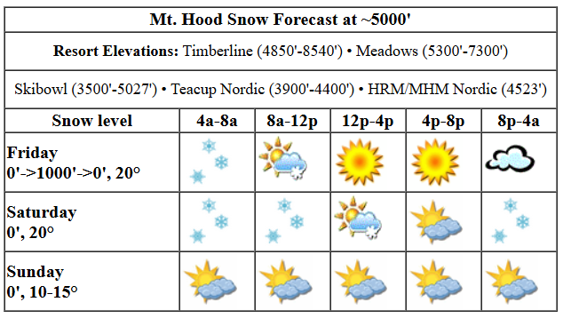
Friday kicks off with very light snowfall, not enough to tip the measuring devices, but enough to let you know it’s winter. Temps at 5000′ were in the mid-teens. If you’re waxing, that’s a blue/cold wax day. We’ll see light snowfall this morning with trace accumulation followed by sunshine this afternoon and a trace of snow and cloudy sky tonight. The snow level will be 0′ this morning, 500-1000′ this afternoon, and back to 0′ tonight. Temps max out in the upper teens at 5000′ today. Wind: NW 10-15 this morning, W 20 this afternoon, and WSW 10-15 overnight.
Light snowfall is forecast for much of the day Saturday, but the slopes will only pick up an inch or so. Expect spectacular packed powder groom and good park and Nordic conditions. The snow level will be 0′ in the morning, 500′ in the afternoon, and back to 0′ under cloudy sky overnight. Wind: WSW 10-15 in the morning, W 15 in the afternoon, and W 5-10 overnight.
Sunday starts cloudy and turns clear by the afternoon. The free air freezing level will be 0′ all day with temps in the upper teens in the morning and mid teens at night. After a busy day on Saturday, the snow surface will likely be transitioning to hardpack, but it’ll still be excellent. Wind: light westerly all day turning to light easterly overnight. Clouds linger up to 6000′ or so on Monday with snow unlikely. Temps will be in the low double digits all day, and the wind will be light easterly. Overnight into Tuesday, the wind picks up , the sky clears, and temps plummet into the single digits. Clear, cold weather sticks around through Wednesday.
Models are converging on a snowy solution for the extended period starting Thursday. They don’t have a handle yet on precipitation quantity or temperatures – that all depends on the path of an incoming low. Just know that we’ll be breaking out of this pattern and transitioning into a snowier one come the latter half of next week. In the meantime, I’ll see you on the snow!
Liking this forecast?
Was that helpful? I knew it was! Guess what? All of this crucial work – from your personal wind and snow reports to the invaluable TATAS updates – is made possible by my relentless efforts. Maintaining this labor of love isn’t easy. Each daily forecast takes hours. Website hosting, weather model access, and back-end admin work takes time and money. That’s where you come in.
YOUR CONTRIBUTION MAKES A DIFFERENCE
- SUPPORT ACCURATE, HYPER-LOCAL WEATHER FORECASTING
- ENABLE ACCESS FOR ALL, EVEN THOSE WITH LESS MEANS
- SUPPORT A COOL HUMAN WHO WORKS HARD SO YOU CAN PLAY
Take a moment to click one of the buttons below. Donate $19.99 or more (how much does this forecast enhance your life?) and get the email in your inbox. Whether it’s a renewing subscription (auto-renew) or a one-time donation, every contribution makes a real difference. Help me keep this labor of love alive, so we can all continue playing, commuting, and living in the Gorge with peace of mind and the best weather forecasts possible. Thank you!


Hood River, Oregon 97031


GORGE WIND FORECAST

Hi friends! Not much going on here for the next few days, and when the wind picks up next week, temps will be sub-freezing all day long. In a fun twist, models suggest the south coast (Pistol River) will be firing Sunday through Tuesday with a W swell of 3-4′ at 15 seconds, which should be a pretty fun swell. Back to the Gorge… Friday starts dead calm. Westerlies pick up to 12-15mph or so this afternoon from Stevenson to the Hatch. River flow over the last 24 hours was 87-132kcfs, river temp is 39.02F, and high temp forecast is 39F with snow in the morning and partly cloudy sky later.
Saturday starts with E 15 at Iwash (Rooster) Rock and 20mph at Stevenson. The wind turns dead calm by the afternoon. High temp: 40F with mostly cloudy sky. Sunday starts with E 15mph at Iwash and light/variable wind near Stevenson. Iwash goes calm, and Stevenson picks up to 10mph. Sunday: light easterlies. Monday through Wednesday: stronger easterlies, but sub-freezing temps. It’s a good time to do some cross-training. PM to join the daily twerk-out!
BARE BONES HOOD RIVER WEATHER FORECAST
Light snowfall this morning followed by partly cloudy sky this afternoon. Temps start near 30 and rise to the upper 30s. Calm wind early. Light to moderate westerlies later. No rainbows. Saturday starts with light snowfall and ends mostly cloud. Temps start near 30 and rise to the upper 30s. Light easterlies early. Calm wind later. No rainbows. Sunday will be mostly cloudy with some light snowfall in the morning followed by partly cloudy sky in the afternoon. Temps start near 30 and rise to the upper 30s. Very light easterlies. No rainbows.
TEMIRA’S AWESOME TRAVEL ADVISORY SERVICE (HYPERLOCAL WEATHER FORECAST FOR THE COLUMBIA GORGE)
Good morning, neighbors! Light and not-so-disruptive snowfall continues on and off for the next few days. Despite the lack of accumulation, you’ll want to approach the roads with caution: it’s slick out there. Much colder weather shows up Monday through Wednesday and sets us up for a potentially very messy period Thursday into next weekend. Deets on that period are far from clear, but if we don’t get snow, I’ll be surprised.
Before we dive in to the forecast, let’s check in with Glenwood: It’s 25 degrees there this morning with a dewpoint of 19 degrees, about average for the area. TATAS Executive Order Of The Day: The Supreme Court shall have an enforceable ethics code with clearly defined, and harsh, penalties for violation. Signed with an ultra-black, fine-tip Sharpie.
FRIDAY
On to the weather! It seems almost all of us are sub-freezing today, at least anyone outside. It’s warm in my house and hopefully in yours. Light snowfall continues this morning as far east as Biggs and throughout the SW/Sherm areas, but just a trace is expected. This system swings through midday and leaves us partly cloudy in the west and sunny to the east, which is really hard to believe considering it’s darn gray and gloomy as I’m writing this. West wind picks up to 10-15mph west of Mosier, and this allows temps to rise to the upper 30s.
SATURDAY
Light snowfall returns to the North Shore as far east as Goldendale after midnight Friday, and snow kicks off along the river as far east as Hood River around sunrise Saturday. Snowiest areas could pick up as much as an inch by snow-stopping time (1pm for Hood River, 7pm for Cascade Locks), but overall, impacts will be un-impactful. Temps will be in the upper 20s in the lowlands to start the day and upper 30s to end it. Wind: E 15-20 in the usual spots in the morning and calm in the afternoon. My paperwork says we could see a few sunbreaks on the west side in the afternoon while the east side turns mostly sunny.
SUNDAY
A weak little system swings a band of light snowfall through the Gorge on Sunday. It marches from west to east and leaves a trace of snow everywhere as far east as Amayah’s Indian Curry and Kababs (the location formerly known as Biggs). Temps will be nearly identical to Saturday: upper 20s to start, upper 30s to finish. All this is accompanied by easterlies at 10-15mph at the usual spots in the morning with calm wind later.
MONDAY THROUGH WEDNESDAY
Monday’s a transition day to a three-day pattern of cold, arid conditions as dry continental air slides in from the NE. By Wednesday, dewpoints drop into the single digits everywhere in the Gorge. That will result in lots of static electricity buildup and a higher chance than normal of finding a new lover as sparks will be flying. THERE’S HOPE FOR ME! While we’ll be cloudy on Monday, the air should dry enough for sunshine by Tuesday afternoon at the latest. High temps for this three day period probably wont’ top 30, and lows could easily dip into the single digits for the coldest spots and teens elsewhere. This period might finally be cold enough for long enough with clear-enough sky at night to freeze some of the lower-elevation ponds. Maybe. I’m itching to try my new-used skates.
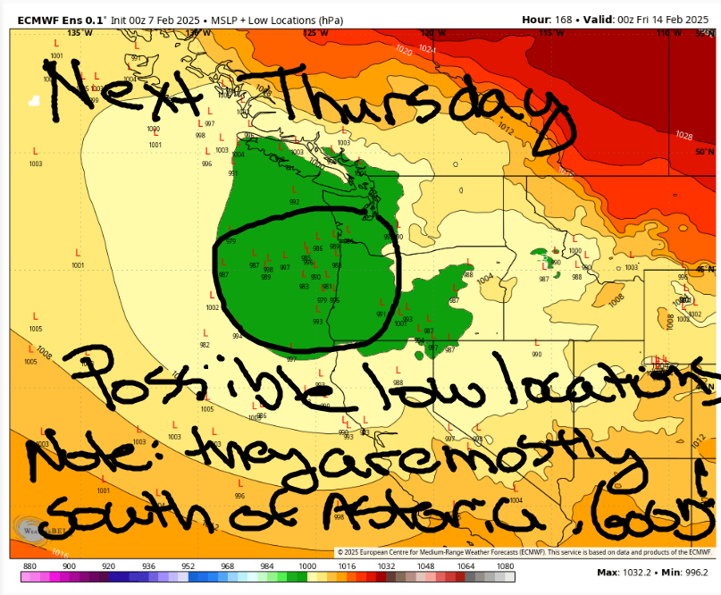
THURSDAY AND BEYOND – POTENTIAL CHAOS
On Thursday, a low offshore does some stuff. As we look at the “member low locations” map, we see that the low center still has some decision-making to complete. If you like snow in the metro area, the current map looks pretty good – the low needs to come in south of Astoria for snowfall on our city brethren. Given the super-duper cold air in place, this system is almost certain to bring snowfall (not something messier, like freezing rain or chocolate pudding from the sky) to the Gorge. Without the path of the low or its proximity clear to us, we can’t make a call on how much snow or when it’ll start. If you want lots of snow, vote for the low to hang out just offshore between Manzanita and Oceanside for an extended period of time. And also vote for it to tap into tropical moisture. And vote for a deep east side cold pool. Hell, while we’re dreaming, let’s vote for the low to intensify so the east wind cranks up and NWS posts a blizzard warning for the Gorge.
It’s worth mentioning that this Thursday system is just the start – there is more “weather” forecast through the weekend. But the type of “weather” really depends on initial conditions, particularly how fast the previous system scours out the very cold, very dry air settled in the Gorge. If you have travel plans for the latter half of next week, be prepared to potentially make some changes as this forecast changes. Safe travels. -TATAS
HEY! DON’T STOP READING! Is this community-focused forecast helpful to you? It sure is! It takes me a couple hours a day to write. Please join your friends and neighbors in contributing to keep it going. Venmo: @thegorgeismygym PayPal: twomirrors@gmail.com USPS: Temira / PO Box 841 / Hood River, Oregon 97031 You can test out the forecast subscription for a few days for free by clicking this link: https://subscribepage.io/YhevGc
