

GORGE WIND FORECAST
Hi friends! So good to be back with you after a month away! Sounds like there were some big days while I was gone, and I’m stoked for those of you who got them. Your favorite Gorge wind forecast is back – daily through the summer with my next break for my annual Labor Day retreat. Good stuff coming up here: we’re heading into a three-day stretch of westerlies, relatively warm westerlies, followed by a lighter spell for a few days and another potentially decent day next Wednesday. So, let’s dive right in to Friday’s forecast, shall we?
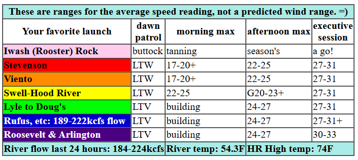
today’s gorge wind forecast (it’s Friday)
The day kicks off with nearly-zero gradients. Pressures were 29.93/29.92/29.91 at 5am, and that’s running behind model predictions. Hopefully the wind does not run late as well. Today’s setup relies on a cold front pushing in to the west side this afternoon while the desert heats up – we’ll have both thermal and frontal assistance with the wind. Aloft: W wind gives a little push, but NW would be better. Models take the Stevenson-Hood River zone to 22-25 by late morning. Frontal lift knocks the Hatch down a bit early afternoon (20-23 Stevenson to Swell) but takes the Hood River-Rufus section up to 24-27. As thermal assistance really kicks in into the evening, we’ll see the entire Gorge, Stevenson to Arlington, rise to the 27-31 zone with a shot at readings of 30-33 from Rowena to Threemile and eventually, perhaps, to Boardman for the Executive Session (after 5pm).
A few additional thoughts: while there may be periods of “right direction” in the Maryhill stretch, I’d prefer to see NW flow aloft and less lift, so expect some gustiness. This is a great setup for the Arlington area. Swell and Hood River will also do well with the potential exception of that early to mid-afternoon time period. Keep an eye on mid to late afternoon there as well as the executive session. River flow over the last 24 hours was 184-224 kcfs (excellent for everything but paddling at Rufus, good for everywhere else), river temp is 54.3F, and high temp forecast is 74F for Hood River and 81F for Arlington. Hopefully that’s enough information to make a good call for yourself!

saturday’s gorge wind forecast
The cold front pushes inland tonight. This drags the marine layer to Rowena-ish and settles mid-level clouds all the way in to the desert to start Saturday. We’ll even see a little rain! Wind speeds start at gusty 16-19 from Stevenson to The Dalles with 24-27 from Lyle to Boardman. The far eastern Gorge dies off as high pressure rebuilds off the California coast. For the rest of the day: a slow builds to 20-23 from Stevenson to Mosier as clouds burn back (likely gusty). Focus should be between Lyle and Rufus: 24-27 for that stretch midday with 28-31 in the afternoon and into the evening. High temp: 61F for Hood River and 62F for Arlington.
sunday’s gorge wind forecast
Sunday currently looks to bring up-and-down conditions from Stevenson to Doug’s (20-23 peak midday with 15-18 early and afternoon) with 23-26 in the afternoon from Mosier to Doug’s. High temp: 66F for Hood River and 67F for Arlington with sun all day. Ensembles agree on light wind for Monday and Tuesday. Most members call for moderately strong wind sometime Wednesday, probably later in the day, as the next cold front swings inland. All right, y’all. Can’t wait to see you on the water today!
Was that helpful? I knew it was! Guess what? All of this crucial work – from your personal wind and snow reports to the invaluable TATAS updates – is made possible by my relentless efforts. Maintaining this labor of love isn’t easy. Each daily forecast takes hours. Website hosting, weather model access, and back-end admin work takes time and money. That’s where you come in.
YOUR CONTRIBUTION MAKES A DIFFERENCE
- SUPPORT ACCURATE, HYPER-LOCAL WEATHER FORECASTING
- ENABLE ACCESS FOR ALL, EVEN THOSE WITH LESS MEANS
- SUPPORT A COOL HUMAN WHO WORKS HARD SO YOU CAN PLAY
Take a moment to click one of the buttons below. Donate $19.99 or more (how much does this forecast enhance your life?) and get the email in your inbox. Whether it’s a renewing subscription (auto-renew) or a one-time donation, every contribution makes a real difference. Help me keep this labor of love alive, so we can all continue playing, commuting, and living in the Gorge with peace of mind and the best weather forecasts possible. Thank you!


Hood River, Oregon 97031


JONES BEACH, SAUVIE ISLAND, & COAST FORECAST
Wind northerly unless otherwise indicated. For coast, numbers are in mph for North/Central/South with the “central” at approximately Florence. Swell forecast from NWS for central coast. Friday: 15/15/LTN, W swell 7′ @ 4 seconds. Saturday: 15/15/25-30, W 7′ @ 13. Sunday, 15-20/25/35-45, W 7′ @ 12. Jones Friday: 10-13. Saturday: 20-23. Sunday: 19-22. Sauvie Island Friday: 12-15 > 5pm. Saturday: NW 15-18. Sunday: NW 18-21.
MT HOOD WEATHER FORECAST
Hey skiers and snowboarders! Thanks for putting up with my extended absence while I was on a silent meditation retreat for a month. It was the most meaningful experience of my life, and I am grateful to you for your support! I’ll put out a ski forecast this weekend, and then you’re on your own for mountain weather until next fall – generally speaking, other than Saturday, there’s not much happening other than sunshine and corn snow.
Friday kicks off sunny on the slopes. We’re expecting clouds and precip later, but almost certainly not until the lifts are done for the day. The free air freezing level will be 11,000′ during the day and will fall to 8000′ overnight with temps at 5000′ maxing out around 50F before falling in the evening. Overnight, we’re expecting about 0.1” to 0.2” rain transitioning to snain (wet snow). Wind will be SSW 10 this morning, WSW 25 this afternoon, and WNW 20-30 overnight.
Saturday kicks off with rain prior to sunrise and wet snow in the morning. Clouds stick around in the afternoon, but they’ll dissipate overnight. The snow level will be 8000′ early and will fall to 4000′ overnight. About 0.2” water equivalent is forecast in the morning for an inch or two of wet snow. Wind: WNW 20-30 in the morning, NBW 20-30 in the afternoon, and NW 25-30 overnight.
Sunday looks sunny with excellent corn snow thanks to clear sky and a hard snap overnight. Meadows will be done for the season, but there should be great turns at T-line. The free air freezing level will be 2500′ in the morning and will rise to 5500′ in the afternoon. Wind: NW 25-30 in the morning, NW 20-25 in the afternoon, and NE 15-20 overnight. Beyond that: lots of sun and unseasonably warm weather with the potential exception of a weather system on Wednesday. Have a fun day on the snow today!
BARE BONES HOOD RIVER WEATHER FORECAST
Sunny today becoming partly cloudy after 5pm and cloudy overnight with drizzle after midnight. Temps start in the mid 40s and rise to the mid 70s. Calm wind early. Strong westerlies later. No rainbows. Saturday starts with drizzle prior to sunrise then stays cloudy the rest of the day. Temps start in the upper 40s and rise to the low 60s. Moderate westerlies. 18% chance of rainbows. Sunday will be sunny. Temps start in the low 40s and rise to the mid 60s. Moderate westerlies. No rainbows.
TEMIRA’S AWESOME TRAVEL ADVISORY SERVICE
HYPERLOCAL WEATHER FORECAST FOR THE COLUMBIA GORGE
THE DALLES, HOOD RIVER, WHITE SALMON, TROUT LAKE, STEVENSON, CASCADE LOCKS, PARKDALE, ODELL, HUSUM, BZ, MILL A, WILLARD, GOLDENDALE, RUFUS, ARLINGTON, boardman

Good morning, neighbors! I hope you all had a wonderful April. Thank you so much for tolerating my month long absence while I did a silent meditation retreat. It was definitely the most meaningful experience of my life. Also… the amount of joy I had this morning opening the weather models so I could tell you all about the weather… I LOVE MY JOB! So, the weather…
glenwood and friday’s weather
Let’s check in with Glenwood: It’s 34 degrees and clear there this morning, and it’s almost certain to frost there on Sunday morning when 850mb temps dip to -2C. We’ll talk about other outlying areas in a bit. For the rest of us today: sunshine most of the day. In the afternoon, a cold front (colder air with some oomph) shoves into the west side like me trying to shove a square peg in a round hole. I’m not good with shapes – this keeps my sex life exciting. The front drives temps down in the west and results in strong westerlies through the entire Gorge. Let’s keep it simple: 25-35mph all the way from Stevenson to Threemile Canyon and beyond. Today’s high temps max out in the mid 70s in the west and low 80s to the east. That’s about 10 degrees above normal, but not 10 degrees above the new climate change normal, I’m pretty sure. Clouds build overnight and combine with lift for a bit of drizzle east of The Dalles and into SW/Sherman counties. Just a trace, tho.
saturday
Full-coverage clouds start Saturday with drizzle west of Lyle and also potentially for areas just east of The Dalles. Models insist on more widespread drizzle from Hood River east to the Tri-Cities mid-morning. We could see 0.1” to 0.2” in the westtest areas. Clouds eventually burn off from west to east late afternoon, leaving those of us at the cloud line and under the clouds with the potential for a stellar sunset that could potentially put you in the same awe-filled mind state as the one the retreat made my new baseline. Saturday’s wind will be 15-20mph west of Mosier in the morning with 20-25mph in the afternoon. From Mosier eastward: 25mph to Boardman in the morning with 25-30mph from Lyle to Rufus in the afternoon. East of Rufus, the wind dies off in the afternoon. Temps max out around 60F everywhere.
sunday’s frost potential and weather
Clear sky Sunday night combines with -2C temps at 5000′ and dewpoints in the mid 20s away from the Nch’i Wana (Columbia). Frost potential is real away from the river in wind-sheltered areas (wind aloft is forecast at NW 15mph, which could be just enough to stir things up and save your ass). We’ll look more closely as we get closer. Along the river: dewpoints will be in the mid 30s with westerlies at 15mph west of The Dalles, so frost potential is lower. Rest of the day: sunshine and mid 60s with west wind at 15-20mph west of Mosier and 25mph from Mosier to The Dalles. Farther east: light.
next week
We start next week with a few days of warm, sunny weather. Orchardists: need to spray? Wind will be very light Monday and Tuesday. Conditions will be FUCKING EPIC for spraying on Tuesday morning. For the rest of us… As far as I am concerned, 65-75 degree sunshine is the most perfect weather of all. There’s a ton of that in the next 10 days. PERFECT.
Valuable Advice for Gardeners Inhabiting Neighboring Areas
There’s still snow on Mt. Defiance. That means you shouldn’t plant tomatoes if you live in the outlying areas. Along the river: go for it, but maybe wait until after Sunday just in case. Now is the time to start your squash and melon seeds (indoors) if you haven’t already. Outside: you can go ahead and plant beets and spinach and, well, many other things including seeds of kindness. The more of those you plant, the better the world will be. Check your soil temp. If it’s at 65F, you can plant beans. Or you can use my method: wait until all the volunteers pop up, and then plant your seeds. As a matter of fact, that’s just a great way to go all around for things that don’t need the head start of indoor sowing: just wait until you see volunteers, and then plant your seeds. Speaking of gardening… it’s time for me to get a move on. I have lots of manure to move. Good to be back with all of you. Safe travels. -TATAS
HEY! DON’T STOP READING! Is this community-focused forecast helpful to you? It sure is! It takes me a couple hours a day to write. Please join your friends and neighbors in contributing to keep it going.
