MT HOOD SNOW FORECAST

Hey skiers and snowboarders! Our ski slopes picked up about 9” over the last couple of days, and things are looking mighty pretty up there this morning! Packed pow conditions greet you today. Nordic folks: it’s a violet wax day. Looking at the next few days, we have snow today with warming temps.
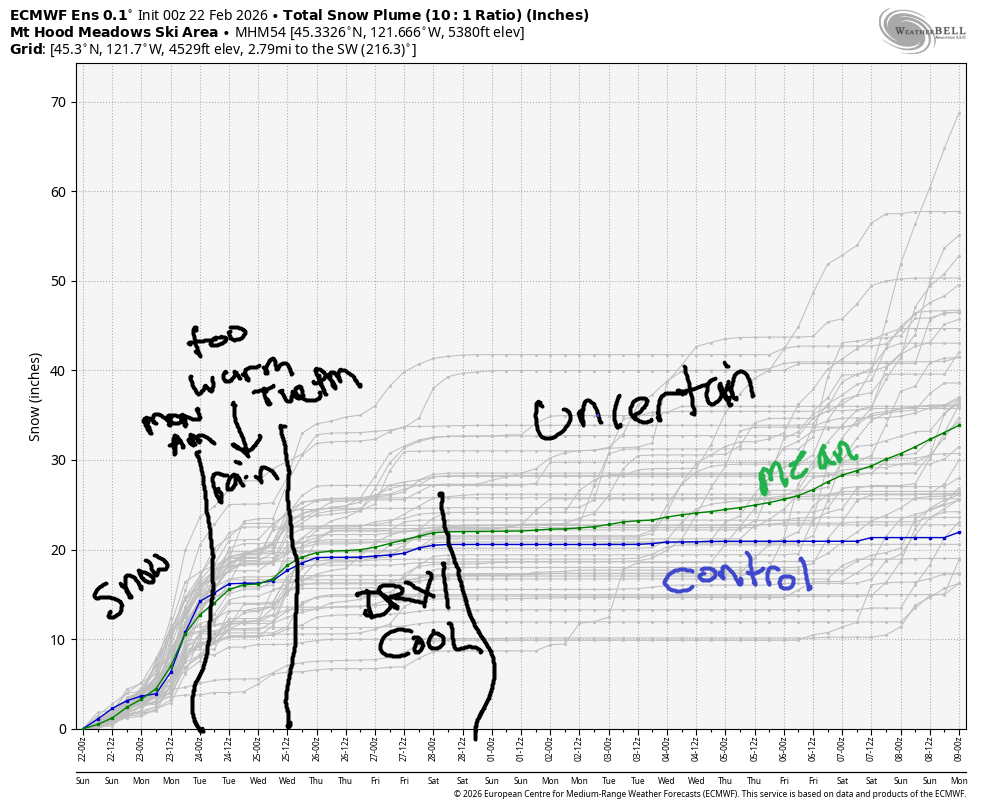
Models suggest snow, wet snow, but snow, will linger into midday Monday before switching to mixed precip below 6000′. Rain is forecast on Tuesday followed by a switch to snow in a favorable orographic situation on Tuesday night. Beyond that: dry for a while with high uncertainty after Thursday. Intraquartile range through Wednesday morning, when things dry out, is 13-20” of new. Through March 8th, models have 24-40” new snow.

Short term Mt Hood snow forecast
Sunday starts off with spectacular packed powder groomed runs and park conditions. Snow starts up before the lifts start loading and just keeps on going. The snow level will be 1500′ early, 4500′ most of the day, and 5000′ after midnight. Temps are forecast to max out in the 32-33F range at 5000′ today once this incoming warmer air mass wears always at the entrenched cool air. We’re expecting 0.3” to 0.4” water equivalent (WE) during the day for 3-4” increasingly dense snow. Overnight, another 0.4” WE is forecast for 3” dense snow. Wind will be SW 30-50 this morning, SW 25-35 this afternoon, and SW 20-40 after midnight.
On Monday, temps will be marginal, but we’ll probably see snow early. The snow level will be around 5000′ early, 6000′ in the afternoon, and 6000-6500′ overnight. About 0.9” WE is forecast during the day as mixed precip at 5000′. Up high, half a foot of snow or more is likely. Overnight, another 0.6” WE is forecast as mixed precip or rain at 5000′ and snow, around 4” way up high. Wind will be SW 20-40 in the morning, SW 30-50 in the afternoon, and SW 15-25 after midnight.
Extended Mt Hood Snow Forecast
Tuesday looks rainy in the morning and snowy/stormy in the evening. The snow level will be 6000-7000′ during the day, and it will crash to 1500′ overnight. About 0.4” rain is expected during the day. That switches to snow after 4pm with about 0.7” WE forecast. Call it 5-7” increasingly dry snow aided by orographics: wind will be SW 15-25 in the morning, WSW 40-50 in the afternoon, and NW 30 (very good for snowfall) overnight.
Wednesday looks breezy with flurries early and sunshine later. The snow level will be 1000′ early, 1500′ in the afternoon, and 2500′ overnight. No accumulation is forecast. Wind will be NW 30-40 early, W 15 in the afternoon, and W 15 overnight. Cool, dry weather is forecast for the next couple of days followed by high levels of uncertainty. Get out there and get some today!
Was that helpful? I knew it was! Guess what? All of this crucial work – from your personal wind and snow reports to the invaluable TATAS updates – is made possible by my relentless efforts. Maintaining this labor of love isn’t easy. Each daily forecast takes hours. Website hosting, weather model access, and back-end admin work takes time and money. That’s where you come in.
YOUR CONTRIBUTION MAKES A DIFFERENCE
- SUPPORT ACCURATE, HYPER-LOCAL WEATHER FORECASTING
- ENABLE ACCESS FOR ALL, EVEN THOSE WITH LESS MEANS
- SUPPORT A COOL HUMAN WHO WORKS HARD SO YOU CAN PLAY
Take a moment to click one of the buttons below. Donate $19.99 or more (how much does this forecast enhance your life?) and get the email in your inbox. Whether it’s a renewing subscription (auto-renew) or a one-time donation, every contribution makes a real difference. Help me keep this labor of love alive, so we can all continue playing, commuting, and living in the Gorge with peace of mind and the best weather forecasts possible. Thank you!


Hood River, Oregon 97031


GORGE WIND FORECAST
If you’re still seeing yesterday’s and it’s after 9am, try opening this in an incognito window

SHORT-TERM gorge wind forecast
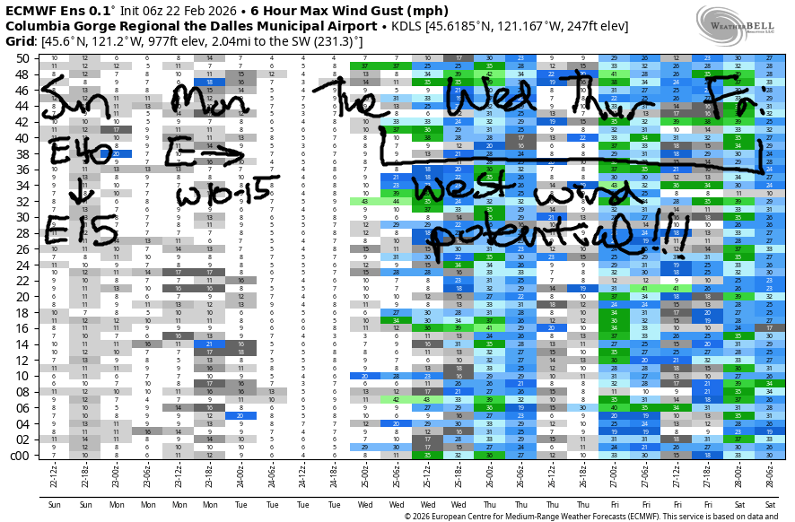
Hi friends! Your week includes a shot at the Hatchery as offshore high pressure sets up on Tuesday afternoon. West wind of some sort is likely through Friday, although model uncertainty is quite high starting at the end of next week.
Sunday started with solid easterlies (pressures: 29.87/30.11/30.14), but they won’t last long. Iwash started the day at 42mph and drops to 15-20mph mid-morning. Stevenson started with 33mph and drops to 15mph mid-morning, fading further in the afternoon. River flow website currently displays “Forbidden” and nothing else (it’s unreliable at times), river temp is 41.4F, and high temp forecast is 47F with rain starting mid-morning.
RIVER FLOW FOR SITES BETWEEN AVERY (EAST OF THE DALLES) AND RUFUS: CLICK HERE FOR JOHN DAY DAM FLOW.
RIVER FLOW FOR SITES BETWEEN STEVENSON AND DOUG’S BEACH (WEST OF THE DALLES): CLICK HERE FOR THE DALLES DAM FLOW

LONGER-TERM gorge wind forecast
Monday starts with easterlies at 10-15mph in the usual spots, turns calm midday, and rises to W 10-13mph from Stevenson to The Dalles in the afternoon. The Rufus area might see 13-16mph. High temp: 48F with lots of rain.
The atmospheric river associated with all this rain lingers through much of Tuesday, but things change in the afternoon; a cold front swings through, and high pressure builds offshore. This turns the flow northwesterly, and if we’re lucky, results in 21-24mph from Stevenson to Mosier. High temp: 48F with rain in the morning and clouds in the afternoon. Offshore high pressure continues Wednesday, Thursday, and potentially Friday with westerlies in the cards through that time period. Fingers crossed the west wind coincides with my non-work time and yours as well!
BARE BONES HOOD RIVER WEATHER FORECAST
Cloudy early with rain by late morning, continuing into the evening and increasing overnight. Temps start in the mid 30s and rise to the upper 40s. Light easterlies. 37% chance of rainbows. Monday will be rainy. Temps start in the upper 30s and rise to the upper 40s. Light easterlies early. Light westerlies later. 96% chance of rainbows. Tuesday will be rainy. Temp start near 40 and rise to the upper 40s. Calm wind most of the day. Moderate westerlies late afternoon. 99% chance of rainbows.
TEMIRA’S AWESOME TRAVEL ADVISORY SERVICE
HYPERLOCAL WEATHER FORECAST FOR THE COLUMBIA GORGE
THE DALLES, HOOD RIVER, WHITE SALMON, TROUT LAKE, STEVENSON, CASCADE LOCKS, PARKDALE, ODELL, HUSUM, BZ, MILL A, WILLARD, GOLDENDALE, RUFUS, ARLINGTON, boardman

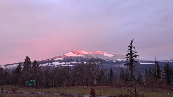
Good morning, neighbors! What a gorgeous morning it is with the snow on the hills and the resulting alpenglow! Rain (maybe even some snow) is incoming today followed by lots of moisture through Tuesday morning. All this wet weather is good timing to get taxes done and onion seeds planted. Now y’all know what I’m doing over the next couple of days! What are you up to?
Glenwood this morning
Looking around the Gorge this morning (it’s Sunday, apparently), we’ve got mostly cloudy sky and a 34 degree start in cloudy Glenwood. People in Glenwood are sad that it’s so warm, so they all have their freezer doors open trying to cool things down. Some of you are below freezing: Parkdale, York Hill, High Prairie, Dufur, Glenwood, and probably Snowden. Precip is incoming, but it’s sure taking its sweet time. It’ll be close – some of you might see a little snow before the switch to rain this afternoon. Roads appear relatively warm this morning. I’m not sure about ice, but nobody’s seen !CE!
Today’s Gorge weather forecast
Rain pushes in to the western Gorge, to Cascade Locks, prior to 10am, and it makes it to Lyle by noon. After noon, light rain spreads east to the Arlington Isosceles Triangle and south Wasco and Sherman Counties (no triangles there) as well as Goldendale. Overnight, the rain extends all the way to the Tri-Cities, where everything has three sides. Temps today max out in the upper 40s, and the snow level climbs to 4500′. Wind will be East wind at 40mph early near Iwash (30mph near Stevenson) fades to 15mph this afternoon.
Monday’s Gorge weather forecast
Rain is forecast all day Monday west of Hood River with moderate rain in the morning and heavy rain, enough for a splashy drive, all the way into Tuesday morning. Areas east of The Dalles (exception: Centerville and Goldendale, which should be drizzly) stay dry until 7pm. After that: drizzle most of the way to Idaho (mostly squares there), including in south Wasco, Sherman, and Gilliam Counties. Monday wind will will be east 10-15mph in the usual spots early with west wind at 10-15mph in the afternoon all through the Gorge. This results in rainbows, potentially double rainbows. If you go to Arlington, the rainbows will be shaped like triangles. Ditto in the Triangle-Cities.
Tuesday’s Gorge weather forecast
Rain continues all day Tuesday daytime for pretty much all of us. It tapers off in the afternoon and leaves us dripping wet. Shake like a dog to dry yourself off, just for fun. Areas west of Mosier hang on to rain into the evening before finally drying out late evening. Tuesday will be a bad day to hang your laundry on the line. Choose the dryer instead. Temps on Tuesday will be near 40 early and 48F in the afternoon with the snow level at 6000-7000′. Streams and rivers rise in response.
Extended Gorge weather forecast
On Wednesday, dry weather returns. We can all shake off the dampness and look around. It’s likely we’ll have icy roads Wednesday morning as temps at 850mb dip to -6C under partly cloudy to mostly clear sky. Dry weather is likely for much of next week. Uncertainty skyrockets next weekend, so I’ll leave this here for now. Safe travels. -TATAS
HEY! DON’T STOP READING! Is this community-focused forecast helpful to you? It sure is! It takes me a couple hours a day to write. Please join your friends and neighbors in contributing to keep it going. Venmo: @thegorgeismygym PayPal: twomirrors@gmail.com USPS: Temira / PO Box 841 / Hood River, Oregon 97031 You can test out the forecast subscription for a few days for free by signing up below. Easy! Do it!
JONES BEACH, SAUVIE ISLAND, & COAST FORECAST
ON WINTER VACATION UNLESS DESPERATELY NEEDED.

