MT HOOD SNOW FORECAST

Hey skiers and snowboarders! While this hasn’t been the driest/coldest of snowstorms, it’s certainly been a helpful one! Meadows base picked up 15” of new in the last 24 hours. Timberline, being a bit higher, picked up 22”. The Meadows mid-mountain stake is reading 29” higher than it was on Sunday, yay! Even the Teacup cam is showing at least some new snow on the trails!
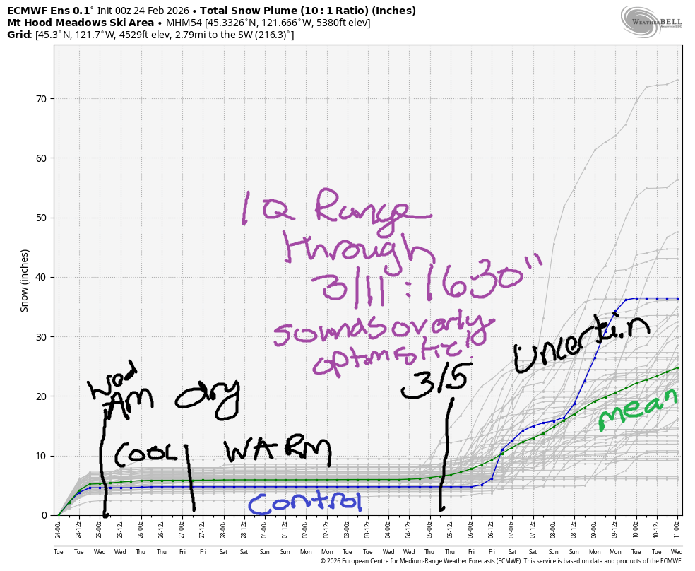
Luck was definitely on our side – this atmospheric river stayed just south enough to keep Mt Hood in somewhat colder air, and the precip stayed mostly snow. This is great news, because we’re looking at another long stretch of warm, dry weather through approximately March 5th. We are sitting pretty to weather (pun intended) the dry spell out!

Short term Mt Hood snow forecast
Tuesday morning started with temps within a degree or two of 32F at 5000′ and the snow level near 1500′ in the Gorge with a true snow level (based on 850mb temps) of around 4000′. Models suggest we’ll see temps climb a little bit and drive the snow level to 5500′ this afternoon before taking it down to 1500′ with a cold front passage overnight. Models have really backed off on snowfall for tonight; yesterday they were suggesting half a foot. Now… a couple inches at best. As for daytime today… we’ll pick up another inch or so of wet snow before this system clears the area. Wind today will be variable to 10 early, W 25 this afternoon, and WNW 25-30 after midnight.
Wednesday may start with a few lingering clouds and orographic flurries, but it’ll quickly turn clear. The snow level will be 1500′ in the morning, 2000′ in the afternoon, and the free air freezing level will fall to 1000′ or less overnight. Wind Wednesday will be WNW 25-30 in the morning, WNW 15-20 in the afternoon, and W 15 after midnight.
Extended Mt Hood Snow Forecast
Thursday looks sunny. The free air freezing level starts around 1500′ or less, rises to 5000′ in the afternoon with temps around 33F at 5000′, and continues to rise to 6000′ overnight. Wind will be W 15 in the morning, W 20 in the afternoon, and WNW 25-30 after midnight. Friday looks clear and breezy with the free air freezing level eventually rising to 8500′ with max temps near 40F.
Dry, warm weather is forecast for the weekend. We’ll continue with dry, warm weather through at least the 5th of March. Break out the sunscreen and T-shirts! See you on the snow!
Was that helpful? I knew it was! Guess what? All of this crucial work – from your personal wind and snow reports to the invaluable TATAS updates – is made possible by my relentless efforts. Maintaining this labor of love isn’t easy. Each daily forecast takes hours. Website hosting, weather model access, and back-end admin work takes time and money. That’s where you come in.
YOUR CONTRIBUTION MAKES A DIFFERENCE
- SUPPORT ACCURATE, HYPER-LOCAL WEATHER FORECASTING
- ENABLE ACCESS FOR ALL, EVEN THOSE WITH LESS MEANS
- SUPPORT A COOL HUMAN WHO WORKS HARD SO YOU CAN PLAY
Take a moment to click one of the buttons below. Donate $19.99 or more (how much does this forecast enhance your life?) and get the email in your inbox. Whether it’s a renewing subscription (auto-renew) or a one-time donation, every contribution makes a real difference. Help me keep this labor of love alive, so we can all continue playing, commuting, and living in the Gorge with peace of mind and the best weather forecasts possible. Thank you!


Hood River, Oregon 97031


GORGE WIND FORECAST
If you’re still seeing yesterday’s and it’s after 9am, try opening this in an incognito window

SHORT-TERM gorge wind forecast
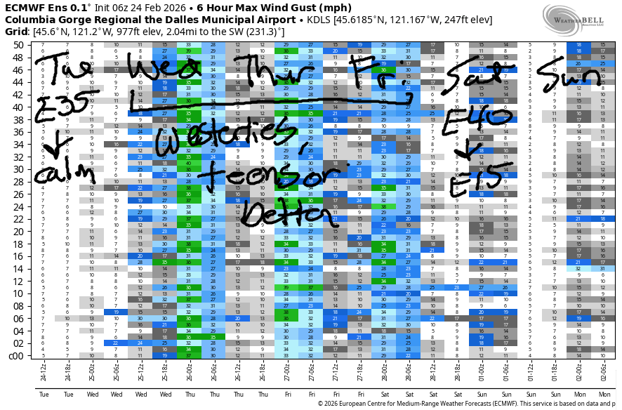
Hi friends! As the system that’s soaked us the last couple of days moves south, we’ll move into an onshore flow large-scale pattern. Offshore high pressure sets up, and although that pressure bleeds inland, we should have enough gradient for west wind of some sort starting Tuesday night! This continues into Friday, after which we’re likely to see easterlies on Saturday and calmish wind on Sunday.
Tuesday started with pressures of 29.91/29.98/29.99. Easterlies were reading 34mph at Iwash/Rooster and 17mph at Stevenson. The wind fades quickly. By late morning, both locations should be under 20mph. The wind turns dead calm after 1pm and switches to westerly overnight as a cold front swings through from the NW and leaves us with offshore high pressure. River flow over the last 24 hours was 148-198kcfs river temp is 41.5F, and high temp forecast is 45F with cloudy sky.
RIVER FLOW FOR SITES BETWEEN AVERY (EAST OF THE DALLES) AND RUFUS: CLICK HERE FOR JOHN DAY DAM FLOW.
RIVER FLOW FOR SITES BETWEEN STEVENSON AND DOUG’S BEACH (WEST OF THE DALLES): CLICK HERE FOR THE DALLES DAM FLOW

LONGER-TERM gorge wind forecast
Wednesday starts with west wind at 13-16mph from Viento to Hood River and 13-16mph from Viento to Rufus with less to the east, west, and in-between. Ensembles are all over the place on eastern Gorge wind in the afternoon; peak gust forecasts are anywhere from 20mph to 40mph. For now, let’s call the afternoon wind 14-17mph from Stevenson to Mosier with 19-22mph (more if we’re lucky!) from Lyle to Rufus with less farther east. High temp: 47F with partly cloudy sky to the west and clear sky to the east. Find the cloud line and go east of it!
Thursday starts with light west wind. Afternoon brings 15-18mph west wind from Stevenson to Threemile. High temp: 50F with sunshine. Friday brings another west wind day. As of right now, models call for light wind in the morning with afternoon westerlies at 20-23mph from Stevenson to Hood River with 11-14mph to the east. High temp: 52F with sunshine. Fingers crossed for a Hatch day!!! Easterlies return Saturday morning at 40mph and fade into the afternoon. Models suggest high pressure will build inland on Sunday and knock the wind speeds below the wind sport threshold. Hope to see you at the Hatch for some west wind action this week!
BARE BONES HOOD RIVER WEATHER FORECAST
Drizzly and cloudy early. Cloudy and dry from mid-morning on. Temps start in the mid 30s and rise to the mid 40s. Light easterlies in the morning. Calm in the afternoon. Westerly overnight. Wednesday will be mostly cloudy then partly cloudy. Temps start in the upper 30s and rise to the upper 40s. Moderate westerlies. No rainbows. Thursday will be mostly clear then clear. Temps start in the low-mid 30s and rise to 50 or so. Light westerlies early. Moderate later. No rainbows.
TEMIRA’S AWESOME TRAVEL ADVISORY SERVICE
HYPERLOCAL WEATHER FORECAST FOR THE COLUMBIA GORGE
THE DALLES, HOOD RIVER, WHITE SALMON, TROUT LAKE, STEVENSON, CASCADE LOCKS, PARKDALE, ODELL, HUSUM, BZ, MILL A, WILLARD, GOLDENDALE, RUFUS, ARLINGTON, boardman

Good morning, neighbors! Drizzly out there this morning, isn’t it? And up in the highest elevations, we have wet snow. Looks like Parkdale, 4” on the ground, is taking the brunt of the winter weather (the sounding model was right after all!). Trout Lake is reading 30F, so I bet it’s snowing there too. And maybe in Snowden! As this system slides south mid-morning, precip stops and temps warm. And that should be the end of snowfall – dry, warm weather is forecast for much of the next two weeks.
Glenwood this morning
Before we discuss the next couple of weeks, we must discuss Glenwood. It’s 33F there this morning, but nobody has told me if it’s raining, snowing, snaining, or doing a mix of all three. That’s probably because only 246 people live in Glenwood, which is on .28% of the people living in the Gorge. Nobody has mentioned !CE in the Gorge either this morning!
Today’s Gorge weather forecast
Anyway…. drizzle continues through late Tuesday morning all the way east to Idaho. It ends first in the north and then tapers off to the south. We all stay cloudy all day. This evening, a weak system arrives from the northwest, sends a little drizzle to Parkdale, the north side hills, and south Wasco and Sherman Counties. Wind today will be E 35mph early at Iwash (pee-pee) Rock and 15-20mph at Stevenson. By mid-afternoon, the wind goes dead calm. Overnight, it turns westerly, but you’ll probably be sleeping, so it probably won’t matter which direction the wind is blowing, unless your dreams vary based on wind direction… Temps Tuesday max out in the mid 40s in the lowlands today with the freezing level eventually rising to 5500′ before falling overnight.
Wednesday’s Gorge weather forecast
By Wednesday morning, the incoming cold front will drop the freezing level to 1500′ with 850mb (~5000′) temps at -4C. The sky will be partly cloudy to the west and sunny to the east. While the forecast is dry after 1am, a few stray sprinkles would be enough to cause rainbows. You are forewarned. In not-windy areas, icy roads are likely, especially if the sky is partly cloudy or clear. Elevated areas with a breeze could also have icy roads. Morning lowland temps: mid to upper 30s. Afternoon temps range from 47F (west) to 49F (The Dalles) to 52F (The Desert). Wind will be westerly at 15-20mph west of The Dalles with stronger wind possible to the east.
Extended Gorge weather forecast
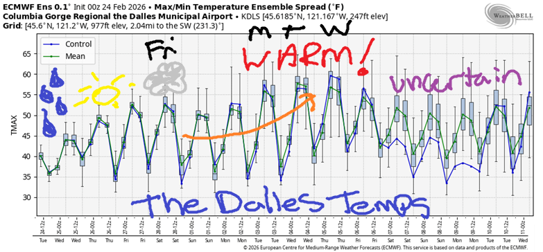
A dry, clear, light wind start is forecast on Thursday. This leaves us all susceptible to icy roads. Lowland temps start at 31-34F. Elevated areas: below freezing. By afternoon, we’ll be 50-53F and sunny. Sunshine!!! Wind will be westerly at 10mph or less in the morning with 15-20mph out of the west in the afternoon. Sunshine continues on Friday and Saturday with 15-25mph west wind and high temps in the low to mid 50s. Clouds are forecast Sunday, but precipitation is unlikely. Dry weather is forecast through next week along with plenty of sunshine. In the middle of the week, high temp forecasts range from 55-60F. WARM! I see gardening and cycling in my future. What good stuff is planned in your future, boo? Safe travels. -TATAS
HEY! DON’T STOP READING! Is this community-focused forecast helpful to you? It sure is! It takes me a couple hours a day to write. Please join your friends and neighbors in contributing to keep it going. Venmo: @thegorgeismygym PayPal: twomirrors@gmail.com USPS: Temira / PO Box 841 / Hood River, Oregon 97031 You can test out the forecast subscription for a few days for free by signing up below. Easy! Do it!
JONES BEACH, SAUVIE ISLAND, & COAST FORECAST
ON WINTER VACATION UNLESS DESPERATELY NEEDED.

