

MT HOOD SNOW FORECAST

Hey skiers and snowboarders! Welcome to March! If my memory works, March is the month of big snow. While long-range models don’t give us consistent big snow this year (lots of above-freezing weather is in the cards for the slopes in the next couple of weeks), there are at least a couple chances for big dumps coming up. Hopefully that’s enough to drag ski season in to April! FYI: I’m not around the next couple of days, so this forecast will have to suffice until I can return to you on Wednesday.
Before I forget… a dear friend of mine was recently diagnosed with ALS. He’s been an avid skier and outdoorsman his whole life. A group of us are doing Ski ALS March 7th at Meadows in his honor. If you’d be so kind as to make a donation to the cause, I’d really appreciate it! Go ahead and do it before you read the forecast so you don’t forget!d today: no new snow for a while, and also no significant weather impacts.
Short term Mt Hood snow forecast
Looking at the weather: we’ll have overcast sky all day Sunday. The free air freezing level hovers around 8000′ all day before dropping to 7000′ overnight. Wind will be calm in the morning, W 10mph in the afternoon, and light northerly overnight. Temps at 5000′ max out in the low 40s. Hopefully the snow will hold up thanks to the clouds – conditions are partially transformed hardpack up high and granular down low.
Monday will be sunny. The free air freezing level starts at 7000′, climbs to 8000′, and finishes up at 6500′. Temps max out around 40F in the afternoon. Wind will be light northerly or NE during the day and will turn to S 10-20 overnight.
Extended Mt Hood Snow Forecast
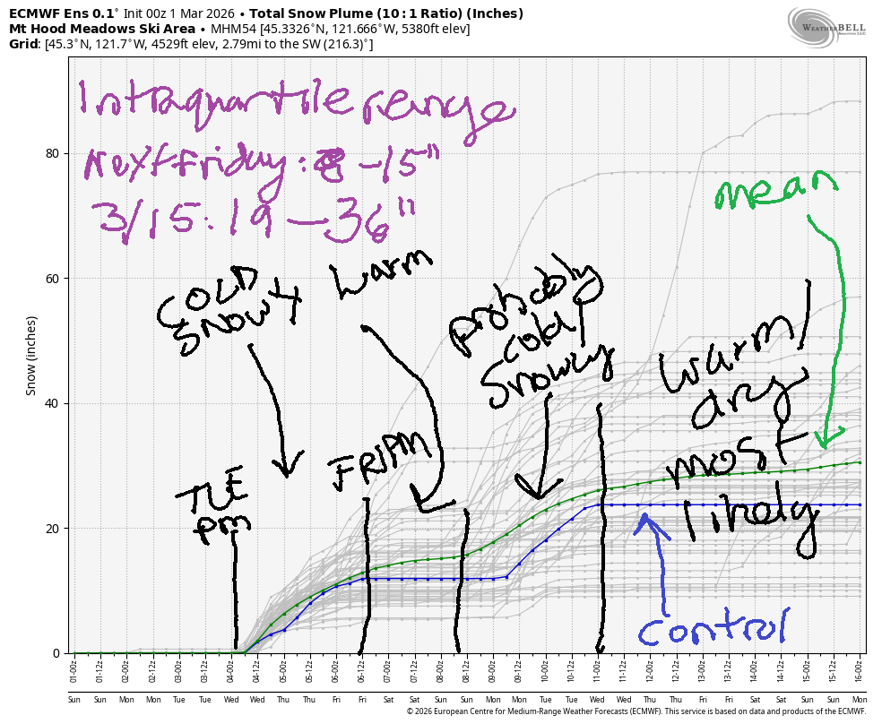
A transition day is in the cards for Tuesday. After a sunny start, a cold front arrives sometimes during the day. Models are all over the place with the timing. That said, the snow level falls from 6500′ before the front to 3500′ with the precip. About 0.6” water equivalent (WE) is forecast for about 6” of new snow. Wind will be S 10-20 in the morning, SW 15-25 pre-frontal in the afternoon, and W 35 after midnight.
Snow continues on Wednesday with the snow level falling from 3000′ to 1500′ at the tail end of the system. Models are all over the place on snow total with this system. Given that the wind direction will swing to WNW and the speed will be around 30mph, we could be looking at a foot of new snow. Fingers crossed! Light snowfall continues into Thursday and potentially Friday.
Beyond Friday, models suggest warmer weather through at least Saturday and potentially Sunday. Models are uncertain if we’ll see precipitation or not. Sometime between late Saturday and Sunday, temps are likely to fall again, and another round of snow is likely. As we move into the middle of the week of the 10th, it’s likely we’ll see much warmer weather. So, cross your fingers for a couple big dumps between now and then. We’ll need it! See you on the snow!
Was that helpful? I knew it was! Guess what? All of this crucial work – from your personal wind and snow reports to the invaluable TATAS updates – is made possible by my relentless efforts. Maintaining this labor of love isn’t easy. Each daily forecast takes hours. Website hosting, weather model access, and back-end admin work takes time and money. That’s where you come in.
YOUR CONTRIBUTION MAKES A DIFFERENCE
- SUPPORT ACCURATE, HYPER-LOCAL WEATHER FORECASTING
- ENABLE ACCESS FOR ALL, EVEN THOSE WITH LESS MEANS
- SUPPORT A COOL HUMAN WHO WORKS HARD SO YOU CAN PLAY
Take a moment to click one of the buttons below. Donate $19.99 or more (how much does this forecast enhance your life?) and get the email in your inbox. Whether it’s a renewing subscription (auto-renew) or a one-time donation, every contribution makes a real difference. Help me keep this labor of love alive, so we can all continue playing, commuting, and living in the Gorge with peace of mind and the best weather forecasts possible. Thank you!


Hood River, Oregon 97031


GORGE WIND FORECAST
If you’re still seeing yesterday’s and it’s after 9am, try opening this in an incognito window
SHORT-TERM gorge wind forecast
Hi friends! Easterlies on Sunday give way to moderate westerlies Monday and Tuesday followed by the potential for stronger westerlies on Wednesday and Thursday. I can’t do a forecast on Monday and Tuesday, but I’ll be back for you on Wednesday!
Sunday started off with pressures of 30.02/30.10/30.10 for offshore gradients and easterlies. Iwash/Rooster started the day at 31mph with 15mph at Stevenson and 20mph at Viento. Stevenson and Iwash settle in at 20-25mph midday before fading to 15mph in the afternoon. River flow over the last 24 hours was 169-192kcfs, river temp is 41.5F, and high temp forecast is 56F with clouds.
Monday starts dead calm with low clouds in the west. We won’t have enough heat for a true summer-style day, but we should see 14-17mph form Stevenson to Hood River in the afternoon. High temp will be 60F with increasing sun during the day.
RIVER FLOW FOR SITES BETWEEN AVERY (EAST OF THE DALLES) AND RUFUS: CLICK HERE FOR JOHN DAY DAM FLOW.
RIVER FLOW FOR SITES BETWEEN STEVENSON AND DOUG’S BEACH (WEST OF THE DALLES): CLICK HERE FOR THE DALLES DAM FLOW

LONGER-TERM gorge wind forecast
A weather system approaching Tuesday keeps the west wind going. Timing is unclear, which means the timing of the wind is also unclear. As of this morning, we’re not expecting all that much – probably 13-16mph from Viento the Hatch prior to the rain arriving and the wind dropping. High temp: 54F with increasing clouds and, eventually, rain.
High pressure builds offshore Wednesday and sticks around for a good portion of the extended forecast. This puts us in a west wind pattern. Areas east of Mosier look like the place to be Wednesday and Thursday, but models currently are hovering around a forecast of 24-27mph out east. Not much is forecast on Friday. Saturday looks a little better.
If we put our faith in the long-range forecast (big leap!), Sunday has serious potential for a big day out in the desert, and so does the following Monday and potentially Tuesday. While nothing that far out in the future is guaranteed, especially when it comes to wind, about 80% of the ensembles are in. I’m clearing 3/8 just in case. Stay safe out there, everyone!
BARE BONES HOOD RIVER WEATHER FORECAST
Overcast sky today. Temp start in the mid 30s and rise tot he mid 50s. Light easterlies. No rainbows. Monday starts cloudy and ends mostly clear. Temps start near 40 and rise to 60!!! Light to moderate westerlies. No rainbows. Tuesday will be cloudy with rain in the evening. Temps start in the low 40s and rise to the mid 50s. Light to moderate westerlies. 71% chance of rainbows.
TEMIRA’S AWESOME TRAVEL ADVISORY SERVICE
HYPERLOCAL WEATHER FORECAST FOR THE COLUMBIA GORGE
THE DALLES, HOOD RIVER, WHITE SALMON, TROUT LAKE, STEVENSON, CASCADE LOCKS, PARKDALE, ODELL, HUSUM, BZ, MILL A, WILLARD, GOLDENDALE, RUFUS, ARLINGTON, boardman
Good morning, neighbors! It’s Sunday, and it’ll be just fine weather today. One heck of a nice day is planned on Monday, so if you have the ability to be “sick”, do it! If you can’t, that’s okay too. Looking out about 10 days, we have pretty good potential for damned nice weather. In the meantime…
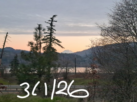
Glenwood this morning
Some of us started the day cloudy (to the south) and some of us started clear (to the north). This set Glenwood up for a big win today: 25F there versus 33-39F on the south side of the river. Everyone in Glenwood is dancing naked in the streets to celebrate their victory. That victory, of course, is muted by concerns about repeated unilateral acts of war by the United States president. War powers are the domain of congress (Article II, Section 2, US Constitution). Also muting the celebration: the murder of dozens of schoolchildren in Iran by the United States war machine. Ask yourself: is this what I want for my relationship with the world? You and I don’t have to agree on everything, but I hope we can agree that this sort of “collateral damage” is 1) not okay and 2) heartbreaking.
Speaking of heartbreaking, nobody has spotted !CE yet this morning in the Gorge. They’re all still in Minnesota despite the mainstream media no longer covering it. The shortness of our attention spans combined with the distraction techniques of this administration is overwhelming the capacity of our press.
Today’s Gorge weather forecast
Today’s weather should not break your heart: it’ll be overcast to the south and sunnier to the north with high temps rising to the mid 50s (average high for the date: 50F). Wind will be strongest at Iwash Rock (30mph fading to 15mph) and Stevenson (20mph fading to 15mph).
Monday’s Gorge weather forecast
Sunday’s high clouds should be gone on Monday morning. They’ll be replaced by low clouds west of Mosier and sunshine to the east. We’re set for a 40F start under the clouds and mid 30s or less under the stars. By afternoon, temps rise to 60-fucking-degrees, 10 degrees above average for the day and 8 degrees shy of the Hood River record of 68F. Monday’s wind starts calm (spray, baby, spray) and ends with 15mph between Stevenson and Hood River with calm wind to the east.
Tuesday’s Gorge weather forecast
A weather system arrives sometime Tuesday. Given that the timing isn’t set, I can’t really give you a truly accurate forecast. You can expect a cloudy day prior to the rain. Rain should be light until the evening, but it’ll increase overnight and become heavy west of Mosier after midnight. Some rain will swing through areas east of Mosier after midnight into Wednesday morning. Tuesday’s high temps will be in the mid 50s, and Tuesday’s wind will be westerly at 10-15mph.
Extended Gorge weather forecast
Lingering showers with cooler weather (highs near 50F) are in the cards through Thursday or Friday. On Thursday morning, the freezing level drops as low as 1500′, which could give us flurries for a few and icy roads for many. Quite a bit of uncertainty is present in the long-range models. Warmth is likely next weekend followed by cooler weather to start the following week and then the possibility of quite a warm spell around Friday the 13th. But that’s way too far out to be making predictions. I”ll leave it here for now and see you when I’m back forecasting on Wednesday. Have a great start to the week. Safe travels. -TATAS
HEY! DON’T STOP READING! Is this community-focused forecast helpful to you? It sure is! It takes me a couple hours a day to write. Please join your friends and neighbors in contributing to keep it going. Venmo: @thegorgeismygym PayPal: twomirrors@gmail.com USPS: Temira / PO Box 841 / Hood River, Oregon 97031 You can test out the forecast subscription for a few days for free by signing up below. Easy! Do it!
JONES BEACH, SAUVIE ISLAND, & COAST FORECAST
ON WINTER VACATION UNLESS DESPERATELY NEEDED.