

MT HOOD SNOW FORECAST

Hey skiers and snowboarders! It’s Thursday, and it’s quite a stormy morning up on Mt. Hood. With the NWAC Meadows telemetry reporting wind direction at 271 degrees (not the temp!!!) and 37-53mph, we’re likely to have some lift ops problems. This isn’t the only day in the near future with lift ops problem potential. We’re having trouble winning this season, eh?
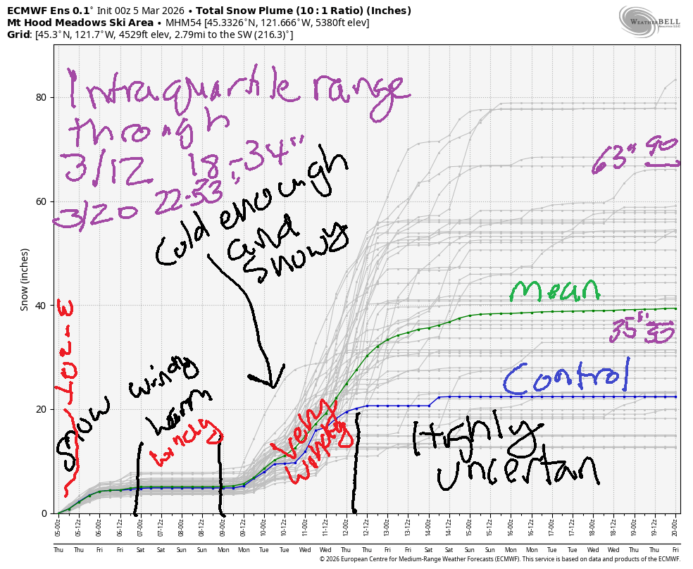
Generally speaking, the Mt Hood snow forecast brings light snowfall into midday Friday when very light drizzle replaces the snow and sticks around into Sunday morning. Snow returns Sunday night with the potential for heavy snowfall next week. The intraquartile range through 3/12 (when there’s decent model agreement) is 18-34”. Through 3/20 (highly uncertain), we have 22-53”.
Short term Mt Hood snow forecast
First things first this morning – I’m participating in Ski ALS at Meadows on Saturday in support of my friend Dick who was recently diagnosed with ALS. If you’d be so kind as to make a contribution (even a few $$) is awesome, I’d be so grateful. Our team name, by the way, is “Full Send For Dick!”. If that made you chuckle, please contribute in support of my awesome friend. If you do it before you read the rest of the forecast, you won’t forget!
Thursday weather is going to be quite stormy up there on Mt Hood. The snow level will be 1500′ in the morning, 2000′ in the afternoon, and 2500′ after midnight. Just 0.1” water equivalent (WE) is in the cards today, and the same overnight. With the daytime wind’s assistance, we might pick up a couple inches of snow. Just an inch is forecast overnight. Wind forecast is NW 30mph all day, which doesn’t sound too bad when you read it, but that direction and speed wreaks havoc on lift ops sometimes. Overnight, the wind falls to W 20. Snow surface is apparently quite wind-affected – scoured, wind-packed, etc.
Friday brings another round of light snowfall. Overnight, temps rise and switch the snow to drizzle. The snow level will be 2500′ early, 6000′ in the afternoon, and 10,000′ after midnight. About 0.2 WE is forecast during the day for a couple inches of new snow. Overnight, just a trace of rain is forecast with temps rising to near 40F at 5000′. Wind will be W 20 in the morning, WNW 20-30 in the afternoon, and NW 35 after midnight.
Extended Mt Hood Snow Forecast
On Saturday, strong wind combines with orographic drizzle, another good reason to make a donation to the Ski ALS event – we’ll all be soaking wet and riding Buttercup if the wind forecast holds! The snow level will be 10,000′-12,000′ all day with intermittent drizzle and strong, lift-affecting wind: NW 35 early, NW 30 in the afternoon, and W 35 after midnight. Under 0.1” rain is forecast, and temps max out near 40F.
Sunday continues the chaos with a cold front approaching and strong WNW wind. The snow level will be 10,000′ in the morning, 6000′ in the afternoon, and 1500′ after midnight. About 0.1” rain is forecast during the day and 0.1” WE snow (and inch or less) overnight. Wind will be W 35 early (fine for lifts), WNW 40 in the afternoon (likely to lose many lifts), and W 25 overnight (doesn’t matter, because the lifts are closed).
Snow flurries are possible Monday with heavier snowfall into Tuesday night. Many ensemble members ramp up the snowfall from Monday until late Wednesday. Beyond that, there’s way too much uncertainty to make a forecast, so I’ll leave it here for now. Please do your snow-calling activities for the Monday-Thursday time period. Vote for the high end of the possible range!
Was that helpful? I knew it was! Guess what? All of this crucial work – from your personal wind and snow reports to the invaluable TATAS updates – is made possible by my relentless efforts. Maintaining this labor of love isn’t easy. Each daily forecast takes hours. Website hosting, weather model access, and back-end admin work takes time and money. That’s where you come in.
YOUR CONTRIBUTION MAKES A DIFFERENCE
- SUPPORT ACCURATE, HYPER-LOCAL WEATHER FORECASTING
- ENABLE ACCESS FOR ALL, EVEN THOSE WITH LESS MEANS
- SUPPORT A COOL HUMAN WHO WORKS HARD SO YOU CAN PLAY
Take a moment to click one of the buttons below. Donate $19.99 or more (how much does this forecast enhance your life?) and get the email in your inbox. Whether it’s a renewing subscription (auto-renew) or a one-time donation, every contribution makes a real difference. Help me keep this labor of love alive, so we can all continue playing, commuting, and living in the Gorge with peace of mind and the best weather forecasts possible. Thank you!


Hood River, Oregon 97031


GORGE WIND FORECAST
If you’re still seeing yesterday’s and it’s after 9am, try opening this in an incognito window
SHORT-TERM gorge wind forecast
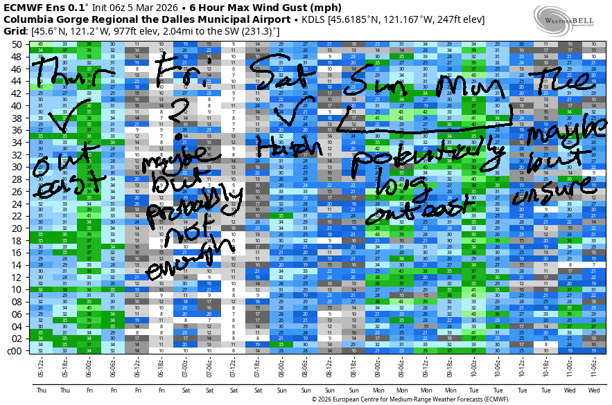
Hi friends! We have quite the stretch of west wind on tap. You’re forgiven if you’re thinking it’s summer based on the forecast, but do remember to keep in mind the cold water and cool air temps. Setup driving the wind: more summery than wintry as offshore high pressure settles in and keeps the W/NW flow going.
Thursday started with pressures of 30.31/30.20/30.10 for impressive gradients of 0.11 (pdx-dls) and 0.10 (dls-psc). Clouds hang in the western Gorge all day which makes the wind very up-and-down west of The Dalles. Out east, well have 22-25 from Avery to Boardman to start the day. The wind rises to 28-31 from Avery to Arlington midday and drops to 20-23 east of Arlington. River flow over the last 24 hours was 150-188kcfs, river temp is 42.3F, and high temp forecast is 49F with drizzle west of Mosier all day long and mostly clear sky out east.
RIVER FLOW FOR SITES BETWEEN AVERY (EAST OF THE DALLES) AND RUFUS: CLICK HERE FOR JOHN DAY DAM FLOW.
RIVER FLOW FOR SITES BETWEEN STEVENSON AND DOUG’S BEACH (WEST OF THE DALLES): CLICK HERE FOR THE DALLES DAM FLOW

LONGER-TERM gorge wind forecast
Friday looks lighter, but models actual have quite a bit of spread for a short term forecast. For now, let’s call it 7-10 west of Avery and 13-16mph from Avery to Hermiston pretty much all day. Rain is forecast as far east as Arlington until mid-morning. High temp: 52F in Hood River and 56F for Rufus.
Strong high pressure combines with an approaching cold front on Saturday for a big day. Naturally… I’ve committed to an all-day event. As of this morning’s model runs, Saturday starts with 19-22 from Viento the Hatch with 20-23 from Philippi Canyon eastward and light wind between the Hatch and Philippi. By midday, we’ll have 24-27+ from Stevenson (drizzly) to Hood River (dry) or Mosier with teens near Rowena and 27-30 from Rufus to Hermiston. If nothing changes, the Hatch will be the place to be. High temp: 57F (!!!) in Hood River and 61F (!!!) at Rufus with low clouds in the west and increasing sunshine out east.
Sunday looks like another 30mph day out east. Models are all over the place for Monday’s forecast, but there’s a decent chance the strong westerlies will stick around. All that should be enough to get you excited. Hope to see you out there! Stay warm and safe!

BARE BONES HOOD RIVER WEATHER FORECAST
Cloudy with intermittent showers/drizzle today. Temps start in the mid 40s and rise to the upper 40s. Moderate westerlies. 99.9% chance of rainbows. Friday will be intermittently drizzly. Temps start in the low 40s and rise to the low 50s. Light westerlies. 99.4% chance of rainbows. Saturday will be mostly dry. Temps start in the mid 40s and rise to the upper 50s. Moderately strong westerlies. 74% chance of rainbows.
TEMIRA’S AWESOME TRAVEL ADVISORY SERVICE
HYPERLOCAL WEATHER FORECAST FOR THE COLUMBIA GORGE
THE DALLES, HOOD RIVER, WHITE SALMON, TROUT LAKE, STEVENSON, CASCADE LOCKS, PARKDALE, ODELL, HUSUM, BZ, MILL A, WILLARD, GOLDENDALE, RUFUS, ARLINGTON, boardman

Good morning, neighbors! Meteorological spring is coming in like… spring (?) with blustery wind, plenty of showers, and lots of rainbows. This is our pattern for the next several days. On Sunday night, a cold front swings inland and brings us colder weather (duh) and a shot at a few flurries for our higher elevations. It’s possible we could see some snow in the lower elevations Monday into Tuesday if everything works out just right. Wouldn’t that be exciting?
Glenwood this morning and some other stuff
Know what’s exciting? All the rainbows out there this morning. We’re sitting pretty at 100% chance of rainbows today. That lofty achievement occurred prior to 7:30am. Other lofty achievements: 38F in Glenwood, and enough wind at the ski resorts to take a bunch of lifts offline. Finally, there is no sign of !CE this morning in the Gorge. Yesterday at Safeway in Hood River, there was a multi-agency operation, but that operation did not involve !CE. Hope that helps clear up some rumors!
Today’s Gorge weather forecast
Today’s weather brings light/intermittent drizzle to Hood River most of the day with clearing sky to the east. Cascade Locks holds on to drizzle until 7pm or so, but the dry weather won’t last long – rain returns overnight at least as far east as The Dalles. Wind will be noticeable: 10-15mph west of Lyle with 25-30mph east of Lyle to the Arlington Triangle and beyond. High temps range from the upper 40s (west) to low 50s (The Dalles) to upper 50s (The Desert).
Friday’s Gorge weather forecast
On Friday morning, we’ll have rain as far east as Celilo Village. This includes south Wasco County. Rain slides eastward and soaks Biggs with drizzle to Arlington’s Triangle before shutting off around 11am. Everyone in Arlington will be out exposing their “triangle” to the rain because rain is great for pubic hair! Cascade Locks holds on to drizzle until 4pm or so. Driving to/from the metro area? Expect moderately heavy rain between 1am and 7am. Friday temps rise to the low 50s (west) and mid 50s (The Dalles) with mostly cloudy sky pretty much all day. West wind will be 10mph west of The Dalles and 15-20mph to the east.
Saturday’s Gorge weather forecast
Saturday’s rain will be most noticeable east of The Dalles where a downpour is expected in the morning. You’ll also find drizzle west of The Dalles until sunrise. Most noticeable weather features Saturday: strong to very strong west wind and temps that rise to 57-63F. WARM! On Saturday night, we lose an hour of sleep and gain an hour of afternoon daylight. Wouldn’t it be amazing if we could leave the clocks at one setting? Apparently BC is choose to go to year-round DST – this is the last time they’re changing the clocks there! I’M SO JEALOUS!!! I LOVE YOU, CANADA! TAKE US OVER AND SAVE US FROM THE CLOCK CHANGE! AND GIVE US UNIVERSAL HEALTH CARE. THANK YOU FOR YOUR ATTENTION TO THIS MATTER!
Extended Gorge weather forecast
Sunday starts out dry and adds some light drizzle west of The Dalles. Wind: pretty strong. High temps: 56-64F. Overnight Sunday into Monday, temps drop and the snow level falls to 1500′ or so. There won’t be much moisture around until Monday night when temps drop even more. That sets us up for some snow potential on Tuesday. With west wind continuing, it’s going to be tough to get temps cold enough for snow along 84-14, but we’ll keep a close eye on it. That’s all for now. Safe travels. -TATAS
HEY! DON’T STOP READING! Is this community-focused forecast helpful to you? It sure is! It takes me a couple hours a day to write. Please join your friends and neighbors in contributing to keep it going. Venmo: @thegorgeismygym PayPal: twomirrors@gmail.com USPS: Temira / PO Box 841 / Hood River, Oregon 97031 You can test out the forecast subscription for a few days for free by signing up below. Easy! Do it!
JONES BEACH, SAUVIE ISLAND, & COAST FORECAST
ON WINTER VACATION UNLESS DESPERATELY NEEDED.