

GORGE WIND FORECAST
If you’re still seeing yesterday’s and it’s after 9am, try opening this in an incognito window AND/OR FLUSHING YOUR CACHE or do a do a hard refresh (Ctrl+Shift+R / Cmd+Shift+R)

SHORT-TERM gorge wind forecast
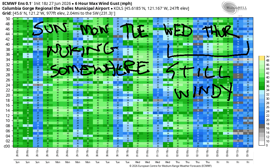
Hi friends! Another big day is on tap in the Gorge wind forecast. Ditto for Monday and Tuesday. While westerlies will back off some Wednesday and Thursday, there will still be plenty of wind for most of you to get some river time. The three-day stretch from Sunday to Tuesday might end up being the windiest of the summer – get on it if you like your wind nuking! Temps generally run in the upper 60s this week west of The Dalles with 75-80 out in the desert. Don’t forget your wetsuit!
Sunday started with pressures of 30.09/29.98/29.91 for gradients of 0.11/0.07, indicating widespread wind today. Offshore: 1030mb. Inland: a big surface low (987mb) in the Idaho/Montana area. Also helping: heat low in the northern WA desert. Dawn Patrol wind was around 20mph all locations from Stevenson to Arlington with 25-28mph at Viento (reads high) and Rufus. If lighter wind is your desire, get it early. By afternoon, Mosier to Threemile rises to 31-35mph and holds into the evening. Boardman rises to 24-27mph.
The western Gorge, Stevenson to Hood River, is trickier thanks to a forecast of persistent cloud cover. Yesterday, the clouds burned back farther than expected and the Hatch over-performed. It was gusty there, but the swell was clean. This is likely to happen today again. So… I’ll make a guess for the Stevenson-Hood River zone this afternoon – gusty 19-23mph under partly cloudy sky. River flow over the last 24 hours was 120-158kcfs (140-158 at Rufus), river temp is 66.0F, and high temp forecast is 68F in Hood River and 73F in Arlington.
RIVER FLOW FOR SITES BETWEEN AVERY (EAST OF THE DALLES) AND RUFUS: CLICK HERE FOR JOHN DAY DAM FLOW.
RIVER FLOW FOR SITES BETWEEN STEVENSON AND DOUG’S BEACH (WEST OF THE DALLES): CLICK HERE FOR THE DALLES DAM FLOW

LONGER-TERM gorge wind forecast
Another big day is on tap Monday. We start with marine clouds on the west side and mostly clear sky to the east. Those marine clouds linger all day. Early wind will be 26-30mph from Viento to Arlington with gusty 18-22mph at Stevenson and 23-26mph at Threemile. Afternoon: gusty 26-29mph in the partly cloudy Stevenson-Mosier zone; 32-36mph (nuking) from Lyle to Arlington, and 24-27mph from Threemile to Boardman. High temps: 66F in Hood River and 71F in Arlington.
Strong wind continues on Tuesday with a slightly better setup for the Hatch. Out east – continued strong westerlies. TJ and Eddy’s Dawn Patrol kicks off with 25-28mph from Viento to Mosier (17-20 at Stevenson) and 22-25mph from Lyle to to Boardman. Give it a couple hours, and the Stevenson-Mosier zone will rise to 26-29mph (maybe a touch more) with 28-32mph from Lyle to Arlington and significantly less wind east of Arlington. High temp: SIX-SEVEN degrees in Hood River and 73F at Arlington.
Forecast complexity increases on Wednesday as the offshore setup becomes more active. We’re still expecting 25-28mph or more. Slightly lesser, gustier westerlies continue in the low to mid 20s on Thursday as a system approaches. Compared to Thursday, Friday will be lighter still, but probably still windy enough. Beyond Friday, uncertainty enters the models in the form of 10-15 degrees of spread in the high temps. Most members of the ensembles indicated continued westerlies of some sort, but the details are impossible to see. By then, you’ll probably be begging for a rest day! See you on the Nch’i Wana soon!

Was that helpful? I knew it was! Guess what? All of this crucial work – from your personal wind and snow reports to the invaluable TATAS updates – is made possible by my relentless efforts. Maintaining this labor of love isn’t easy. Each daily forecast takes hours. Website hosting, weather model access, and back-end admin work takes time and money. That’s where you come in.
YOUR CONTRIBUTION MAKES A DIFFERENCE
- SUPPORT ACCURATE, HYPER-LOCAL WEATHER FORECASTING
- ENABLE ACCESS FOR ALL, EVEN THOSE WITH LESS MEANS
- SUPPORT A COOL HUMAN WHO WORKS HARD SO YOU CAN PLAY
Take a moment to click one of the buttons below. Donate $19.99 or more (how much does this forecast enhance your life?) and get the email in your inbox. Whether it’s a renewing subscription (auto-renew) or a one-time donation, every contribution makes a real difference. Help me keep this labor of love alive, so we can all continue playing, commuting, and living in the Gorge with peace of mind and the best weather forecasts possible. Thank you!


Hood River, Oregon 97031


JONES BEACH, SAUVIE ISLAND, & COAST FORECAST
Wind northerly unless otherwise indicated. For coast, it’s North/Central/South with the “central” at approximately Florence. Swell forecast from NWS for central coast. Jones: westerly unless otherwise stated. Sauvie Island: northerly unless otherwise stated.
Coast Sunday: NW10-15/NW10/N25, NW swell 6′ @ 9 seconds. Monday: NW10-15/LTNW/N30-35, NW 7′ @ 10. Tuesday: LTNW/NW10/N 30, NW 7′ @ 10. Jones Sunday: 10-13. Monday: LTW. Tuesday: 12-15. Sauvie Island Sunday: 12-15. Monday: LTNW. Tuesday: NW 10-13.
BARE BONES HOOD RIVER WEATHER FORECAST
Cloudy this morning. Partly to mostly cloudy later. Temps start in the upper 50s and rise to the upper 60s. Moderate to moderately strong westerlies. No rainbows. Monday will be cloudy then partly to mostly cloudy. Temps start near 50 and rise to the mid 60s. Strong westerlies. No rainbows. Tuesday will be cloudy them partly cloudy. Temps start near 50 and rise to the upper 60s. Strong westerlies. No rainbows.
TEMIRA’S AWESOME TRAVEL ADVISORY SERVICE
HYPERLOCAL WEATHER FORECAST FOR THE COLUMBIA GORGE
THE DALLES, HOOD RIVER, WHITE SALMON, TROUT LAKE, STEVENSON, CASCADE LOCKS, PARKDALE, ODELL, HUSUM, BZ, MILL A, WILLARD, GOLDENDALE, RUFUS, ARLINGTON, boardman

Good morning, neighbors! Cool, cloudy weather continues for the next few days. As a matter of fact, the forecast is so consistent that I’m going to keep it short. Other than areas west of Cascade Locks, the forecast is dry for the next week or two. Main highlights: unseasonably cool and very windy. Stay vigilant with flames and sparks – with this much wind, any fires that do start will spread quickly.
Glenwood this morning & our friends around the world
Glenwood this morning was quite cool: 39 degrees thanks to 850mb temps at +3C. Chilly! Looking at the volcanoes (and the Meadows webcams), there’s a little fresh snow above 7000′. We’ll take it! Around the world today in areas where millions have been threatened by the Rump administration, we have…
Tehran, Iran: 97, sunny, 12% humidity
Havana, Cuba: 83, sunny, 80% humidity
Muscat, Oman: 92, sunny, 74% humidity
Caracas, Venezuela: 70, cloudy, chance of rain, 87% humidity
Nuuk, Greenland: 39, partly cloudy, 89% humidity
Gaza City: 85, sunny, 63% humidity
Ottawa, Ontario, Canada: 65F, sunny, 67% humidity
Today’s Gorge weather forecast
In the Gorge today, tomorrow, and Tuesday…. Cloudy to the west, partly cloudy near The Dalles, and a mix of mid and high clouds in the desert. Mornings will be 50-55ish degrees. Afternoons: 66-68F in Hood River, 72-73F in The Dalles, and 78-81F in the desert. West wind will be 30+ mph each afternoon east of Mosier. West of Mosier, the wind will vary a bit more: Sunday – 20-25mph; Monday: 25-30mph; Tuesday: 25-30mph. Each day will also bring some light drizzle in the mornings west of Cascade Locks, perhaps extending to Cascade Locks early in the day. That’s it for Sunday through Tuesday!
Extended Gorge weather forecast
Wednesday looks similar in terms of temps and cloud cover (cloudy west of Hood River), but the wind will be a touch lighter at 25mph. Thursday: similar to Wednesday.
MY WHAT AN EASY FORECAST WE HAVE TODAY!
A slow warming trend initiates Thursday or Friday. Beyond that, significant uncertainty arises in the models with 10-15 degrees of spread in forecast high temps. General comments: basically no rain, basically no signs of extreme heat, and basically no further damage to cherry crops. We like that. Safe travels. -TATAS
HEY! DON’T STOP READING! Is this community-focused forecast helpful to you? It sure is! It takes me a couple hours a day to write. Please join your friends and neighbors in contributing to keep it going. Venmo: @thegorgeismygym PayPal: twomirrors@gmail.com USPS: Temira / PO Box 841 / Hood River, Oregon 97031 You can test out the forecast subscription for a few days for free by signing up below. Easy! Do it!
MT HOOD SNOW FORECAST

QR codes and links for end-of-season tips – thank you!!!
Cash/check: Temira – PO BOX 841 – Hood River, Oregon 97031

