pretty photos to come when the snow melts.
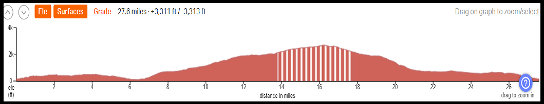
Basic Loop: 27.6 miles, 3311′ elevation gain
Longer Version (adds Dry Creek, Osburne, Carrol, Mosier Creek) 37 miles, 4853′
Best time of year: spring, summer, fall (snow-covered in winter)
GPX file for the 27.6 mile loop
GPX file for the route that adds Dry Creek
Every ride in the Gorge is beautiful, at least in this writer’s opinion. Some have spectacular views. Some have wildflowers. Some are just remote and peaceful. This ride is one of those remote, peaceful rides. You’ll get wildflowers too if you time it right.
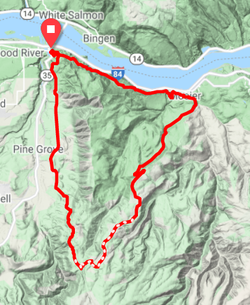
Start in Hood River and ride the Twin Tunnels to Mosier. You can also start at La Vaquita taqueria in Mosier. Pro Tip: starting at La Vaquita means you’ll finish at La Vaquita, and you’ll be happy you did. Anyway, take any of the roads in Mosier a block south from Highway 30 to 3rd street. Turn left. Go less than 1/4 mile and take a right on Huskey Road (you could also keep going on 3rd, take a right on Moiser Creek, go a few miles and take a right on Wilson – that’ll get you to the same place with a harder climb).
Huskey climbs a windless, sunny, hot mile on pavement (anything over 70 degrees is going to be hot AF there) before leveling off in a beautiful meadow. Wildflowers in spring, yes. Keep going. The road turns to pavement and climbs for several miles at 2-6%. It’s 2/3 shade, 1/3 sun. At the intersection of Huskey and Elder, take a left. Climb steeply 1/4 mile to the intersection of Wilson and Huskey. Go right/straight. Not left, unless you want a short loop back to Mosier.
Climb. Climb more. Keep climbing. Depending on the time of day, it’ll probably be 50/50 sun and shade. Bring plenty of water. There is no creek to drink from. There are also no turns, although there are intersecting roads that may confuse you. Eventually you’ll top out in a widely-spaced deciduous planting. It’s a quick drop down to the intersection of Fir Mountain Road and (a ton of Google does not reveal the name/number of this forest road). Anyway, go right. Do not go left, or you’ll end up going a long, long, long ways through patchwork timber harvest on your way to the 44 Road. Descend Fir Mountain Road. It’s good gravel for the first half and excellent chipseal with views of the Hood River Valley for the second half.
You’ll go down a very steep descent (this is why we do this ride clockwise – climbing this is brutal and requires paperboying) into orchards. The road goes up a short hill and curves left. 150 yards later, you’ll take a right on Eastside Road. Stay on that until it forks into Eastside and Highline. Stay right to take Highline. Go flat for a bit and drop down a steep hill. Take a right to return to Moiser (and tacos) via the Twin Tunnels. Go left to return to Hood River. Wipe the shit-eating grin off your face. Yes, we know this is a spectacular ride. This is exactly the reason you bought a gravel bike!