

MT HOOD SNOW FORECAST

Hey skiers and snowboarders! Santa dropped off an inch or so of snow last night, and he’s bringing another 5-9” in time for Boxing Day. After Friday, we’re looking at a cold and sunny Saturday followed by at least three days of warmer, sunnier weather for Mt. Hood.
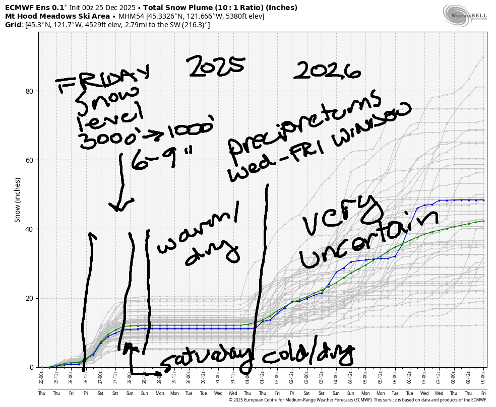
Precipitation returns to the Mt Hood snow forecast sometime in the Wednesday through Friday window. As of right now, too much uncertainty exists to make a precipitation-type forecast, so I’ll hold off. Best guess: probably some rain at the front end and then some snow, but let’s not get too tied to that.
Short term Mt Hood snow forecast
Looking at Thursday… Mt Hood started off with overcast sky and the temp right at freezing. We’ll see light mixed precip or wet snow into the afternoon with dry, cloudy weather overnight. The snow level will be 5000′ in the morning and 3000′ after midnight. Just 0.1” water equivalent (WE) is forecast for up to an inch of new at the highest elevations and a trace down low. Wind: S 15-30 in the morning, 15-25 in the afternoon, and light/variable overnight.
Snow, honest-to-goodness snow, is forecast on Friday. The snow level starts around 3000′, falls to 1500′ in the afternoon, and the freezing level drops to 5000′ under clearing sky overnight. As of this morning, we’re looking at about 0.5” WE during the day for 5-6” new. In the evening, before the snow stops, we pick up another 0.2” WE for 2-3” dry powder. Wind: light/variable early, W 20-25 around sunrise, W 30 in the afternoon, and NW 30-35 in the evening and overnight. If we get lucky, that NW wind could add 20-25% to the forecast snow total.
Extended Mt Hood Snow Forecast
Saturday starts off clear, cold, and breezy with a few flurries. It quickly turns clear. The snow level will be 500-1000′ with temps at 5000′ in the low 20s. Just a trace of snow is forecast before the sun comes out. Wind: NW 30-40 in the morning, NW 10-15 in the afternoon, and N 10 overnight.
Sunday looks cloudy to start and clear late with the free air freezing level rising from 0′ in the morning to 5500′ in the afternoon and 6500′ after midnight. Wind: N 10 in the morning, light easterly in the afternoon, and light SE overnight. Monday and Tuesday look warmer – temps at 850mb (~5000′) are forecast to be in the mid 30s to as much as 50F depending on locations. Wind should be light and variable. Precipitation returns sometime in the Wednesday through Friday window, probably starting as rain and then switching to snow, but significant uncertainty is present. Let’s hold that forecast lightly and celebrate Friday’s incoming snow! Hope to see you on the snow soon!
Was that helpful? I knew it was! Guess what? All of this crucial work – from your personal wind and snow reports to the invaluable TATAS updates – is made possible by my relentless efforts. Maintaining this labor of love isn’t easy. Each daily forecast takes hours. Website hosting, weather model access, and back-end admin work takes time and money. That’s where you come in.
YOUR CONTRIBUTION MAKES A DIFFERENCE
- SUPPORT ACCURATE, HYPER-LOCAL WEATHER FORECASTING
- ENABLE ACCESS FOR ALL, EVEN THOSE WITH LESS MEANS
- SUPPORT A COOL HUMAN WHO WORKS HARD SO YOU CAN PLAY
Take a moment to click one of the buttons below. Donate $19.99 or more (how much does this forecast enhance your life?) and get the email in your inbox. Whether it’s a renewing subscription (auto-renew) or a one-time donation, every contribution makes a real difference. Help me keep this labor of love alive, so we can all continue playing, commuting, and living in the Gorge with peace of mind and the best weather forecasts possible. Thank you!


Hood River, Oregon 97031


GORGE WIND FORECAST
If you’re still seeing yesterday’s and it’s after 9am, try opening this in an incognito window
SHORT-TERM gorge wind forecast
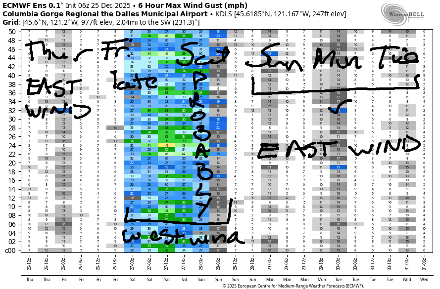
Hi friends! Merry Christmas! May your stocking contain new foils and wind for the forecast! I can offer up the wind part, but someone else will have to get you the foils. We’ve got easterlies on tap today followed by westerlies on Friday and Saturday. High pressure builds inland and sets us up for an extended period of moderate to moderately strong easterlies for several days next week.
Looking at Christmas morning gradients, we find 29.50/29.63/29.66 for 0.13/0.03. That’s enough for mid 30s at Iwash (Rooster) Rock and 20mph at Stevenson and Viento prior to dawn. Wind speed holds in the mid 30s at Iwash and rises to 25-30mph at Stevenson with 20-25mph at Viento. That holds until 11am or so, after which the slow fade begins. At sunset, we’ll have light/variable wind at Iwash and E 15mph at Stevenson. River flow over the last 24 hours was 168-203kcfs, river temp is 47.5F, and high temp forecast is 45F with showers early and mostly clear sky later.
RIVER FLOW FOR SITES BETWEEN AVERY (EAST OF THE DALLES) AND RUFUS: CLICK HERE FOR JOHN DAY DAM FLOW.
RIVER FLOW FOR SITES BETWEEN STEVENSON AND DOUG’S BEACH (WEST OF THE DALLES): CLICK HERE FOR THE DALLES DAM FLOW

LONGER-TERM gorge wind forecast
Friday starts with light easterlies but quickly turns westerly as a system swings through. By mid-morning, westerlies should be 10-13mph west of Mosier, light between Mosier and The Dalles, and gusty 18-23mph between Avery and Arlington. Afternoon wind, if the timing is right, rises to 18-22mph from Stevenson to Arlington. That said, we’ll have showers possible as far east as The Dalles until 4pm, so… (tosses hands up in the air)… Best chance will be late morning on, east of The Dalles, and out of the rain. High temp: 44F.
Models show uncertainty about Saturday’s wind: the trusty 12k keeps us calm. The 4/3k gives us west wind at 18-21mph from Stevenson to Doug’s. It’s all going to depend on how quickly high pressure builds inland and how cold the desert gets overnight. Desert cooling wins the game from Sunday onward; we’ll be in a standard-issue winter easterly setup through at least Tuesday or perhaps longer… it all depends on when the ridge breaks down. If you’re desperate for wind sport time, you should have a chance this week. Watch for debris in the water from recent heavy rains. Enjoy!
BARE BONES HOOD RIVER WEATHER FORECAST
Drizzle this morning, dry midday, showers later. Temps start in the upper 30s and rise to the mid 40s. Light easterlies. 71% chance of rainbows. Friday will be dry to start and rainy from late morning on. Temps start in the mid 30s and rise to the mid 40s. Light to moderate westerlies. 99% chance of rainbows. Saturday will be mostly cloudy. Temps start in the mid 30s and rise to the low 40s. Moderate westerlies. 6% chance of rainbows.
TEMIRA’S AWESOME TRAVEL ADVISORY SERVICE
HYPERLOCAL WEATHER FORECAST FOR THE COLUMBIA GORGE
THE DALLES, HOOD RIVER, WHITE SALMON, TROUT LAKE, STEVENSON, CASCADE LOCKS, PARKDALE, ODELL, HUSUM, BZ, MILL A, WILLARD, GOLDENDALE, RUFUS, ARLINGTON, boardman
Good morning, neighbors! Merry Christmas to all of you celebrating! And happy Chinese food day to all of my Jewish friends! It is Christmas today, and apparently it’s also winter, but you’d be hard-pressed to find real evidence of that in the forecast. Most wintry thing coming up in the next week is a brief period of somewhat colder weather Friday into Sunday morning, when we could actually see a hard freeze for some areas. Starting Saturday, we head into a period of dry, inverted weather with temps pushing into the upper 40s in the mountains with sun possible down low.
Glenwood this morning
Up in Glenwood this morning, it’s 36 degrees and everyone’s dusting off their Santa costumes after delivering presents all over the Gorge all last night. Here’s the big secret: Santa doesn’t actually reside at the North Pole – it’s a remote location with weather too extreme for reliable delivery. Santa, and all the Santa minions, elves, and reindeer, lives in Glenwood. Shhhh. Don’t tell the kids, or you’ll have BDE (big drive energy) taking the family to Glenwood today for photos on Santa’s lap.
Christmas Day Gorge weather forecast
Christmas Day starts with light rain showers. They persist until mid-morning as far east as the Tri-Cities, but mostly west of The Dalles. After a few hours of dry weather, we’re treated to another round of intermittent showers from 1pm to 7pm mostly in south Wasco and from Hood River east to Biggs. Today’s high temps will be in the mid 40s. Snow level: 5000′. Wind: E 40 at Iwash (dick) Rock to start with 25-30mph at Stevenson. The wind goes calm at Dick Rock this afternoon, and Stevenson drops to 15mph. Elsewhere: relatively light wind all day.
Boxing Day Gorge weather forecast
Moving on to Boxing Day, St. Stephen’s Day, a day to practice generosity towards humans of lesser means, we’ll have another semi-drizzly, rather cloudy day. Drizzle extends as far east as the Tri Cities early and as far east as The Dalles until late morning or early afternoon. South Wasco sees rain prior to sunrise. That rain’s from the SW. Another round of rain arrives from the west and gives us moderate rain, enough to make for a frustrating drive, early to mid afternoon. With this system from the west comes colder air – the snow level will fall to 1000-1500′. Up to an inch is possible for Mill A, Willard, Trout Lake, Underwood, and perhaps Snowden. Morning temps will be in the mid 30s. Afternoon: 44F to the west and 48F to the east.
Wind will be E 15mph (usual spots) Friday morning and west 15-20mph from Stevenson to the Arlington Triangle in the afternoon. The combo of west wind and rain gives us partly cloudy sky and lots of rainbows. Don’t look at the rainbows, because they’ll turn you queer like TATAS. It’s just like all those LGBTQ+ kids books, you know. Anything remotely related to gayness will turn you and your loved ones gay. Um, just to be clear, that’s not true. Sexual orientation and gender identity is determined by genetic factors, not knowledge. Knowledge just reduces stigma and shame and increases happiness.
Saturday’s Gorge weather forecast
On Saturday, after a pre-dawn drizzle west of Hood River, we’ll have a dry day. Low clouds stick around in the west, but sun takes over to the east. With cooler air aloft, the freezing level will be around 1000′ or less – thanks to radiational cooling, icy roads are possible anywhere the roads were wet overnight. Rest of the day: temps rise to the low 40s (west and east) and mid 40s (The Dalles). West wind is likely to be in the 15-20mph range west of Avery and lighter to the east, but that could change.
Extended Gorge weather forecast
On Saturday night, clear sky should stick around long enough to take us all below freezing by Sunday morning. Temps aloft start warming. Result: inversion, but not necessarily an inversion-related Nothing cloud. Inversion sticks around into the middle of next week, when models hint at precipitatoin returning. We’ll look more closely at the details of this as we get closer. Safe travels. -TATAS
HEY! DON’T STOP READING! Is this community-focused forecast helpful to you? It sure is! It takes me a couple hours a day to write. Please join your friends and neighbors in contributing to keep it going. Venmo: @thegorgeismygym PayPal: twomirrors@gmail.com USPS: Temira / PO Box 841 / Hood River, Oregon 97031 You can test out the forecast subscription for a few days for free by signing up below. Easy! Do it!
JONES BEACH, SAUVIE ISLAND, & COAST FORECAST
ON WINTER VACATION UNLESS DESPERATELY NEEDED.
