

GORGE WIND FORECAST
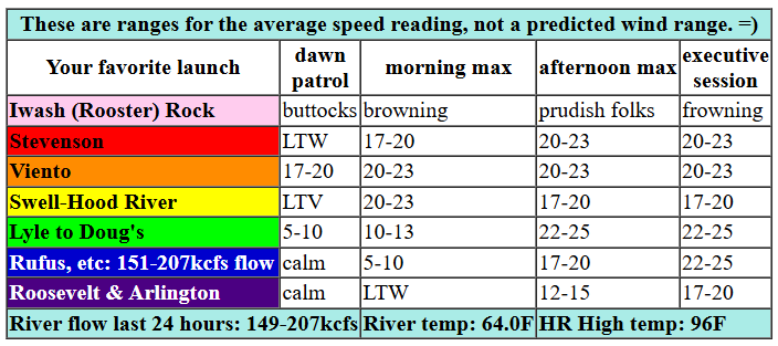
today’s gorge wind forecast
Hi friends! Hopefully you enjoyed your rest day yesterday and had a nice dip in a cooling body of water. That’s all the rest you get for now if 20mph is your lower limit for wind sports. Gorge wind forecast for the next week: windy! We’ll have convection-oven wind today followed by slowly cooling temps and slowly increasing wind for the rest of the week. Like strong wind? Wednesday and Thursday are the biggest days this week. Wondering about next weekend? It’s probably going to be windy too.
Monday started off with calm wind, but pressure gradients were far from flat: 29.94/29.89/29.88 for 0.05 and 0.01. Viento was the only windy spot at dawn: 19mph. As the high pressure ridge and associated hottest temps shift east of the Cascades today, westerlies build into the afternoon. We’ll see a slow start. By late morning, westerlies rise to 19-22 from Stevenson to Mosier. In the afternoon, the Mosier-Avery zone rises to 22-25 with Swell falling to 17-20 . In the evening, Rufus-Arlington join at 17-20 and 100 degrees. River flow over the last 24 hours was 149-207kcfs (151-207 at Rufus), river temp is 643.0F, and high temp forecast is 96F for Hood River and 100+ out in the desert.

tomorrow’s gorge wind forecast
The Cooldown You’ve Been Looking For starts on Tuesday as high pressure lingers well offshore and a heat low refuses to leave the desert. Dawn Patrol opens the day with 20-23 from Viento to Mosier and 10-13 at both Stevenson and the Rowena area. By mid-morning, we’ll have 23-26 from Stevenson to Mosier with 10-13 from Lyle to Doug’s. Afternoon wind falls to 17-20 between Swell and Hood River with 22-25 from Stevenson to Viento and also from Mosier to Rufus. Models like the idea of a resurgence for the Executive Session (after 5pm) with 23-26 from Stevenson to Rufus. It’s worth mentioning that there will be a passing weak disturbance that could make the wind 1) rather gusty and 2) less strong than expected, especially near the Hatch and Hood River. High temp: 90F for Hood River and 100F out in the desert.
extended Gorge wind forecast
Heat lingers in the desert on Wednesday while cooler air infiltrates the west side. As of this morning, TJ’s Dawn Patrol looks like 26-29 from Viento to Mosier with 20-23 out to Rufus. Give it a couple hours, and you’ll find 30-33 from Stevenson to Avery (the Swell sensor will probably read a little lower, but it’ll still be VERY windy). Afternoon: 30-33 from Stevenson to Rufus with 27-30 at Arlington and 23-26 at Threemile. If clouds burn off quickly in the metro area (and models suggest they will), the Swell-Hood River zone could drop off late morning or early afternoon. High temp: 86F for Hood River and 86F for Arlington. Very strong wind continues on Thursday. Friday brings a better chance for lingering marine clouds which (probably) will focus the wind east of Hood River. Wind continues for the weekend, but the ensembles have more range in wind speeds than for the rest of the week. Have a great day on the river today!
Was that helpful? I knew it was! Guess what? All of this crucial work – from your personal wind and snow reports to the invaluable TATAS updates – is made possible by my relentless efforts. Maintaining this labor of love isn’t easy. Each daily forecast takes hours. Website hosting, weather model access, and back-end admin work takes time and money. That’s where you come in.
YOUR CONTRIBUTION MAKES A DIFFERENCE
- SUPPORT ACCURATE, HYPER-LOCAL WEATHER FORECASTING
- ENABLE ACCESS FOR ALL, EVEN THOSE WITH LESS MEANS
- SUPPORT A COOL HUMAN WHO WORKS HARD SO YOU CAN PLAY
Take a moment to click one of the buttons below. Donate $19.99 or more (how much does this forecast enhance your life?) and get the email in your inbox. Whether it’s a renewing subscription (auto-renew) or a one-time donation, every contribution makes a real difference. Help me keep this labor of love alive, so we can all continue playing, commuting, and living in the Gorge with peace of mind and the best weather forecasts possible. Thank you!


Hood River, Oregon 97031


JONES BEACH, SAUVIE ISLAND, & COAST FORECAST
Wind northerly unless otherwise indicated. For coast, it’s North/Central/South with the “central” at approximately Florence. Swell forecast from NWS for central coast. Jones: westerly unless otherwise stated. Sauvie Island: northerly unless otherwise stated. Monday: 20/20/25, NW swell 8′ at 11 seconds. Tuesday: 15-20/20/25, NW 7′ @ 10. Wednesday: 10-15/10-15/25-30, NW 7′ @ 9. Jones Monday: 23-26. Tuesday: 25-28. Wednesday: 24-27. Sauvie Island Monday: 14-17. Tuesday: 15-18. Wednesday: 18-21.
BARE BONES HOOD RIVER WEATHER FORECAST
Clear sky all day. Temps start in the mid 60s and rise to the mi d90s. Moderate westerlies. No rainbows. Tuesday will be mostly clear with some high clouds. Temps start in the low 60s and rise to 90. Moderately strong westerlies. No rainbows. Wednesday will be clear early with high clouds later. Temps start in the upper 50s and rise to the low 80s. Strong westerlies. No rainbows.
TEMIRA’S AWESOME TRAVEL ADVISORY SERVICE
HYPERLOCAL WEATHER FORECAST FOR THE COLUMBIA GORGE
THE DALLES, HOOD RIVER, WHITE SALMON, TROUT LAKE, STEVENSON, CASCADE LOCKS, PARKDALE, ODELL, HUSUM, BZ, MILL A, WILLARD, GOLDENDALE, RUFUS, ARLINGTON, boardman
Good morning, neighbors! “HOT AND MUGGY” is a good description of today’s start. At HoodRiverWeather.info, it was 68 degrees with a dewpoint of 56 degrees when I woke up. Most locations around the Gorge were in the 60s this morning with a few unlucky souls attempting sleep in locations that never dropped below 70 last night. The hot start gives us a hand up in the heat category today – it’s going to be another blistering one. Fortunately, temps will be on a downward trend after today. On Friday, temps aren’t even forecast to break 70 degrees!
fire danger this week
Before we check in with Glenwood, let’s check in with fire danger. A Red Flag Warning was posted by NWS Pendleton for areas east of Underwood today. Lest you think this is silly, let’s talk about the Maryhill Loops Fire. That started yesterday, and despite the wind being light (just 10-15mph, and only for a few hours), that fire reached 700 acres before it was contained and extinguished. Much stronger wind, lesser humidity, and continued heat are in the cards for the next few days. Please consider postponing burning until cooler, more humid weather arrives late this week. Also postpone activities that cause sparks – mowing, weed whacking, forgetting to secure your trailer chains, tossing cigarette and joint butts, online dating, in-person dating, and bumping uglies outside. Let’s go for a fire-free week, shall we?
glenwood’s morning
On to Glenwood: perfectly pleasant there this morning with a low of 52 degrees. Folks are sitting in a circle sipping coffee and sharing stories of Sasquatch sightings. It’s so warm, there’s no need for a campfire. And that’s good, because some burn bans (Hood River County, for example) go into effect today.
today’s gorge weather forecast
For the rest of us… the day starts calm, mild and clear. It finishes hot AF and breezy. Temps rise to the mid 90s to the west, 100 near The Dalles, and 104 out in the desert. Westerlies rise to 20-25mph everywhere between Stevenson and The Dalles this afternoon and Stevenson to Arlington this evening. That puts all of us at risk of wildfires. Please do your part and don’t start one. Speak up (gently, with care and kindness) if you see someone doing something that might cause a fire.
tuesday’s gorge weather forecast
Five degrees of heat disappears on Tuesday, thankfully, but it’ll still be hot: 90 in the west, 95 near The Dalles, and 101 out in the desert, where the Bighorn Sheep will be swimming in the Nch’i Wana with the Boardheads. Speaking of boardheads… Tuesday’s wind: 20-25mph all day between Stevenson and Mosier with areas as far east as Rufus joining at 25mph in the afternoon. Arlington Triangle: free the pubes in your triangle and let them blow in the breeze. You’ll have 15-20mph in the evening.
extended gorge weather forecast and obligatory mention of private parts
Fire danger goes off the charts on Wednesday and Thursday as low-humidity air combines with very, very strong west wind. At least temps will be down. Highs hang around 80 in the west and 90-95 in the desert, where the watermelons will be growing so fast they’ll get a big head and think they can put out fires just by being watery. That is not the case. Extinguishing fires takes firefighters and water, not watermelons. The best day of the week, as far as I’m concerned, is Friday. High temps should be under 70 degrees most places. Such an unexpected and unseasonable chill – Hood River’s normal high for that date is 72 – will result in astonishingly perky nipples and unexpectedly reclusive testicles. Let’s end on that note. Safe travels. -TATAS
HEY! DON’T STOP READING! Is this community-focused forecast helpful to you? It sure is! It takes me a couple hours a day to write. Please join your friends and neighbors in contributing to keep it going. Venmo: @thegorgeismygym PayPal: twomirrors@gmail.com USPS: Temira / PO Box 841 / Hood River, Oregon 97031 You can test out the forecast subscription for a few days for free by signing up below. Easy! Do it!

Leave a Reply