

GORGE WIND FORECAST
today’s gorge wind forecast
Hi friends! I’m running a little late this morning – woke up late, led a meditation group… But the wind isn’t waiting. It was already in the “enough” category as I was writing this. And the Gorge wind forecast says the wind isn’t going anywhere any time soon! Models are bouncing around a bit for the Saturday-Monday time frame, but they generally are in the 17-20mph range or better for at least part of each day. Sunday looks like the lightest of the bunch. Things really ramp up starting late Tuesday or perhaps not until Tuesday night. Then we have a couple of big days on tap next Wednesday and Thursday thanks to plummeting temps in the west and heat in the desert. Before I forget… if you left your NSI wing harness at the Waterfront Park on Wednesday night, I have it. I’ll drop it off at the Port lost and found today if I don’t hear from you.
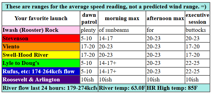
Let’s look at Friday. TGIF! And a big welcome to everyone who’s coming down to escape the heat with some time on the river. Early pressures on Friday were 30.02/29.94/29.93 for graadients of 0.08 and 0.01. Wind as I was writing this was 17-20 from Viento to Swell. By midday, the wind ramps up to 20-23 from Stevenson to Mosier and with 14-17 from Lyle to Avery. Wait until mid-afternoon, and you’ll have 20-23 from Stevenson to Hood River (Swell may dip to 16-19) with 22-25 from Lyle to Rufus. River flow over the last 24 hours was 174-274kcfs (174-264 at Rufus), river temp is 63.0F (time for my red wetsuit!), and high temp forecast is 85F for Hood River.

tomorrow’s gorge wind forecast
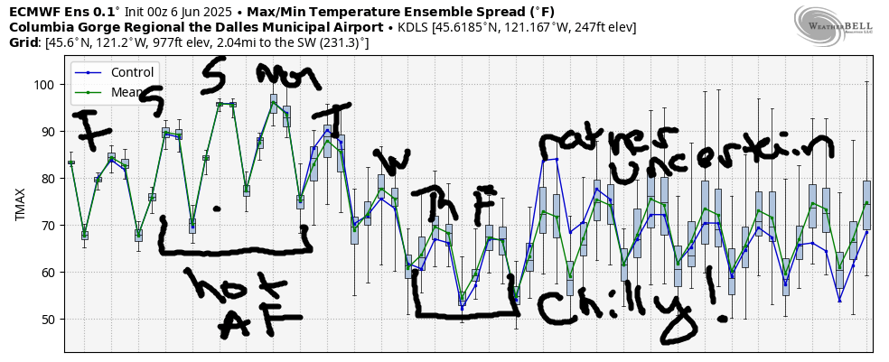
High pressure builds inland on Saturday, but it appears it won’t shut down the wind. We start with 17-20 from Viento to Hood River. A short period of 21-24 from Stevenson to Hood River is possible mid-morning with 17-20 at Mosier. Afternoon wind falls to 17-20 and fills in all the way from Stevenson to Doug’s. High temp: 91F for Hood River. Sunday looks even hotter: 97 degrees. But guess what? The GFS insists we’ll have afternoon westerlies at 17-20 or a bit more from Stevenson to Doug’s. Ensembles: not so certain. That’s your best chance for a rest day in the next week!
extended Gorge wind forecast
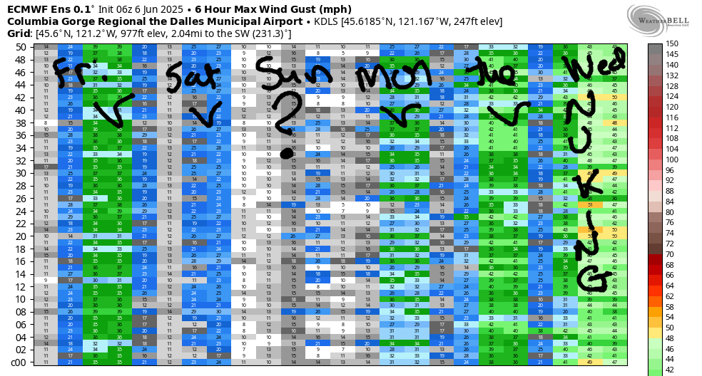
Optimism continues from Monday on into next week as temps slowly stair-step downwards, eventually falling below normal mid-week. While the timing of the cooldown has shifted a bit later in the week, the style of cooldown has not changed: it looks like the right kind. Monday and Tuesday look windy. Wednesday and Thursday look like nukers. Peering into the future beyond Thursday, I see wind. You’ll have to make your own rest day, because it doesn’t look like Ma Nature is going to provide one. Have a great day on the river! See you on the Nch’i Wana!
Was that helpful? I knew it was! Guess what? All of this crucial work – from your personal wind and snow reports to the invaluable TATAS updates – is made possible by my relentless efforts. Maintaining this labor of love isn’t easy. Each daily forecast takes hours. Website hosting, weather model access, and back-end admin work takes time and money. That’s where you come in.
YOUR CONTRIBUTION MAKES A DIFFERENCE
- SUPPORT ACCURATE, HYPER-LOCAL WEATHER FORECASTING
- ENABLE ACCESS FOR ALL, EVEN THOSE WITH LESS MEANS
- SUPPORT A COOL HUMAN WHO WORKS HARD SO YOU CAN PLAY
Take a moment to click one of the buttons below. Donate $19.99 or more (how much does this forecast enhance your life?) and get the email in your inbox. Whether it’s a renewing subscription (auto-renew) or a one-time donation, every contribution makes a real difference. Help me keep this labor of love alive, so we can all continue playing, commuting, and living in the Gorge with peace of mind and the best weather forecasts possible. Thank you!


Hood River, Oregon 97031


JONES BEACH, SAUVIE ISLAND, & COAST FORECAST
Wind northerly unless otherwise indicated. For coast, it’s North/Central/South with the “central” at approximately Florence. Swell forecast from NWS for central coast. Jones: westerly unless otherwise stated. Sauvie Island: northerly unless otherwise stated. Friday: 20/20/30-35, NW swell 6′ at 9 seconds. Saturday: 15/15-20/20-25, NW 6′ @ 9. Sunday: 15/15-20/25, NW 5′ @ 9. Jones Friday: 23-26. Saturday: 17-20. Sunday: 22-25. Sauvie Island Friday: 13-16. Saturday: 10-13. Sunday: 9-12.
BARE BONES HOOD RIVER WEATHER FORECAST
Friday kicks off with a few high clouds. They eventually disappear. Temps start near 60 and rise to the mid 80s. Moderate westerlies. No rainbows. Saturday will be clear. Temps start in the upper 50s and rise to 90 or so. Moderate to moderately strong westerlies. No rainbows. Sunday will be sunny. Temps start in the low 90s and rise to the upper 90s. Moderate westerlies. No rainbows.
TEMIRA’S AWESOME TRAVEL ADVISORY SERVICE
HYPERLOCAL WEATHER FORECAST FOR THE COLUMBIA GORGE
THE DALLES, HOOD RIVER, WHITE SALMON, TROUT LAKE, STEVENSON, CASCADE LOCKS, PARKDALE, ODELL, HUSUM, BZ, MILL A, WILLARD, GOLDENDALE, RUFUS, ARLINGTON, boardman
Good morning, neighbors! It’s Friday, and we’re off to a warm and humid start. I have all my windows and doors open (I have two of each), and the impact on my indoor temp is minimal. You’ll want to be proactive about storing cool air over the next five days or so – our first real heat wave of the season is looming. While we’re not looking at widespread triple digits, we’re still looking mighty warm.
Glenwood’s start and today’s gorge weather forecast
But first, let’s check in on a place that resists morning heating: Glenwood. Today started out 49 degrees there, perfect for opening windows and doors and cooling home, whether home is a house, a car, a cabin, a tent, a treehouse or a cave. Away from the hinterlands, temps started around 60 degrees. The forecast high today is 85, but maybe it’ll be hotter thanks to the hot start. We’ll have a bit of a cooling breeze: 15-20mph from Stevenson to Mosier this morning and 20-25mph from Stevenson to Rufus this afternoon.
Saturday’s gorge weather forecast
Saturday looks hot. 90 degrees or so after a start in the upper 50s to low 60s many places. Far western locations could see a few clouds early, but clear sky is forecast pretty much all day for all of us. West wind hovers around 15-20mph between Viento and Hood River in the morning and Stevenson to The Dalles in the afternoon. Sunday looks similar, but it’ll start 3-5 degrees warmer and finish in the mid to upper 90s. That means I’ll probably finish in the river. If you do that, be aware of the possibility of cold water shock. Our little rivers are still very chilly, and the Big River is 63 degrees, about the temp of the pool at the swim camp I went to one summer as a teenager. It was AWFUL!
extended gorge weather forecast
Highs are a bit less certain on Sunday, but it still looks hot – 90+. Ditto Monday – we’ll drop 5 degrees or so. By the middle of next week, high temps will be right around Sunday’s low temps: mid 60s. Wow. That’s quite chilly for this time of year. That said, record low-highs for next week are 58-59 degrees; those records are unlikely to fall. Accompanying those cooler temps will be very, very, very strong west wind on (probably) Wednesday and Thursday. Beyond that, the ensembles hold high temps in the 70-80 degree range for the extended period. I approve of that forecast. Safe travels. -TATAS
HEY! DON’T STOP READING! Is this community-focused forecast helpful to you? It sure is! It takes me a couple hours a day to write. Please join your friends and neighbors in contributing to keep it going. Venmo: @thegorgeismygym PayPal: twomirrors@gmail.com USPS: Temira / PO Box 841 / Hood River, Oregon 97031 You can test out the forecast subscription for a few days for free by signing up below. Easy! Do it!

Leave a Reply