

GORGE WIND FORECAST
today’s gorge wind forecast
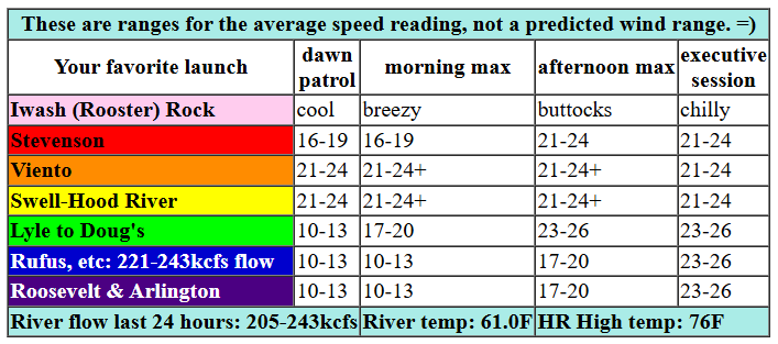
Hi friends! Welcome to another windy day in the Gorge! Yesterday’s peak was 40mph average at The Wall, and Mosier appeared to be keeping pace with that in the evening. It won’t be as windy today, but it will be windy. And ditto tomorrow… as a matter of fact, the Gorge wind forecast for the next six days is for moderately strong to strong wind every single day!
Sunday started off with pressures of 30.28/30.18/30.17 for gradients of 0.10 (pdx-dls) and 0.01 (dls-psc). It’s important to note that the North Pacific High is currently weighing in at 30.62 – very, very strong. This setup usually results in reality beating forecast models. The GFS suggests we’ll have a light morning – 14-17mph – followed by a stronger, thermally-driven afternoon with the focus on the Mosier-Doug’s section of the river. I’m going to go out on a limb and call for 21-24 from Viento to Hood River all day. I don’t want to go too far out on that limb, but that offshore high pressure is so strong that I wouldn’t be surprised if westerlies are even stronger.
Stevenson joins at 21-24 mid to late morning. From Mosier to Doug’s, we’ll have 10-13 this morning and 23-26 this afternoon. Avery climbs to 14-17 in the afternoon. East of Avery, the wind will be under 15mph until the evening. Celilo-Rufus join at 23-26 after 5pm. River flow over the last 24 hours was 205-223kcfs (221-243kcfs at Rufus, where the current was making things disorganized at times yesterday), river temp is 61F, and high temp forecast is 76F for Hood River.

tomorrow’s gorge wind forecast
Monday looks quite similar to today: 18-21 from Viento to Hood River to start with 10-13mph or less to the east of Hood River and also at Stevenson, which may be cloudy. Afternoon drops to 16-19 at Swell and rises to 23-26 from Mosier to Avery. Rufus and Arlington join after 5pm. High temp: 77F.
extended Gorge wind forecast
Tuesday‘s Dawn Patrol looks like 21-24+ from Viento to Mosier with clouds and less wind at Stevenson and 12-15 from Lyle to Arlington. Mid-morning brings 26-29 from Stevenson to Mosier with 18-21 from Lyle to Avery. Stevenson-Hood River holds at 26-29, and Lyle to Rufus rise to 28-32 in the afternoon. For the Executive Session (after 5pm), Arlington and Threemile join at 27-30. High temp: 78F for Hood River and 78F at Arlington.
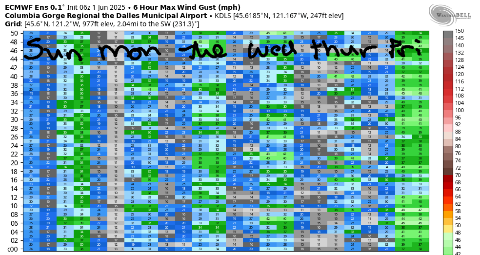
Strong westerlies continue through Friday. Models have been shifting around quite a bit on next weekend’s weather. It looks warmer, but the intensity and duration of the heat have been decreasing. As of today, there are hints of a calm or easterly day on Saturday followed by maybe wind / maybe not wind for Sunday. Looking at the image of the ECMWF ensemble, we see what appears to be a lot of uncertainty on wind strength this week. That’s probably due to the fact that the nearest ensemble data point we have is The Dalles, and it doesn’t accurately capture wind for the Corridor and Near East. So… be optimistic about this week. Plan for lots of wind. See you on the Nch’i Wana!
Was that helpful? I knew it was! Guess what? All of this crucial work – from your personal wind and snow reports to the invaluable TATAS updates – is made possible by my relentless efforts. Maintaining this labor of love isn’t easy. Each daily forecast takes hours. Website hosting, weather model access, and back-end admin work takes time and money. That’s where you come in.
YOUR CONTRIBUTION MAKES A DIFFERENCE
- SUPPORT ACCURATE, HYPER-LOCAL WEATHER FORECASTING
- ENABLE ACCESS FOR ALL, EVEN THOSE WITH LESS MEANS
- SUPPORT A COOL HUMAN WHO WORKS HARD SO YOU CAN PLAY
Take a moment to click one of the buttons below. Donate $19.99 or more (how much does this forecast enhance your life?) and get the email in your inbox. Whether it’s a renewing subscription (auto-renew) or a one-time donation, every contribution makes a real difference. Help me keep this labor of love alive, so we can all continue playing, commuting, and living in the Gorge with peace of mind and the best weather forecasts possible. Thank you!


Hood River, Oregon 97031


JONES BEACH, SAUVIE ISLAND, & COAST FORECAST
Wind northerly unless otherwise indicated. For coast, it’s North/Central/South with the “central” at approximately Florence. Swell forecast from NWS for central coast. Jones: westerly unless otherwise stated. Sauvie Island: northerly unless otherwise stated. Sunday: 20-25/25-30/nuking, NW swell 5′ at 9 seconds. Monday: NNW 10-15/N15-20/30-40, NW 7′ @ 8. Tuesday: 15/15-20/30-40, NW 7′ @ 9. Jones Sunday: 20-23. Monday: 22-25. Tuesday: LTW.
BARE BONES HOOD RIVER WEATHER FORECAST
Clear sky today. Temps start in the low 50s and rise to the mid 70s. Moderately strong westerlies. No rainbows. Monday will be sunny. Temps start in the upper 40s and rise to the mid/upper 70s. Strong westerlies. No rainbows. Tuesday will be sunny. Temps start near 50 and rise to the upper 70s. Strong westerlies. No rainbows.
TEMIRA’S AWESOME TRAVEL ADVISORY SERVICE
HYPERLOCAL WEATHER FORECAST FOR THE COLUMBIA GORGE
THE DALLES, HOOD RIVER, WHITE SALMON, TROUT LAKE, STEVENSON, CASCADE LOCKS, PARKDALE, ODELL, HUSUM, BZ, MILL A, WILLARD, GOLDENDALE, RUFUS, ARLINGTON, boardman
Good morning, neighbors! It’s the first of June, and classic July Gorge weather continues all week long: temps in the mid to upper 70s with strong west wind. Yeah, we’re running about 6 degrees above normal all week long. No rain in sight. We do have a shot at the Aurora Borealis tonight, so prepare yourself for an interrupted night of sleep… My sleep was interrupted last night repeatedly by a hungry cat – I didn’t open the holes wide enough in the food ball for the food to come out. So sorry, kitty!
Glenwood this morning and today’s Gorge weather forecast
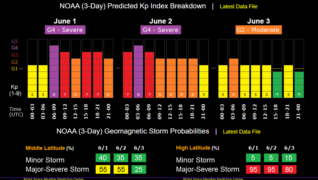
Moving on from my cat to our friends in Glenwood – they’re warming up fast. Temps have risen from 35 degrees to 38 degrees in the last hour. It’s still cold enough to warrant a pair of gloves and a lap blanket / lap cat / lap dog while drinking coffee on the porch. We all warm up to the mid/upper 70s today. Low clouds on the west side burn off, and we’re all left with sunshine. Westerlies rise to 20mph west of Mosier and 25mph from Mosier to Rufus this afternoon. Clear sky, or nearly clear sky, is forecast tonight, which sets us up for good aurora viewing this evening. We’re expecting a G4 storm with a KP level potentially reaching 8 between 7pm and 10pm and KP 7 from 10pm to 1am. So, best viewing is from whenever it gets dark to 1am, in theory. I’m no expert on space weather, despite occasionally being a space case.
extended gorge weather forecast
Looking at next week, we have pretty much identical weather day after day. Temps start in the upper 40s to low 50s and finish up in the mid to upper 70s. West wind sticks around every day at 15-25mph in the morning and 25-30mph in the afternoon. Strongest wind will be focused west of The Dalles, but westerlies will spread eastward in the evenings. Warmer weather is likely next weekend, but there’s a fair bit of uncertainty – maybe 10 degrees of spread in the possible high temps. That’s all for now. Safe travels. -TATAS
HEY! DON’T STOP READING! Is this community-focused forecast helpful to you? It sure is! It takes me a couple hours a day to write. Please join your friends and neighbors in contributing to keep it going. Venmo: @thegorgeismygym PayPal: twomirrors@gmail.com USPS: Temira / PO Box 841 / Hood River, Oregon 97031 You can test out the forecast subscription for a few days for free by signing up below. Easy! Do it!
