

GORGE WIND FORECAST
today’s gorge wind forecast
Hi friends! High pressure builds inland today for a two-day warm spell and a one-day no-wind spell. We’re back to westerlies in the Gorge wind forecast, potentially very strong westerlies, starting late in the day on Wednesday. Strong wind persists Thursday. We’re left with ridging and heat and easterlies on Friday. Looking at the weekend, we’ve got good potential for very strong wind both days as strong offshore high pressure combines with an inland heat low for big to ginormous cross-Cascade pressure gradients. It’s a good thing we’ve got Friday squished in there as a rest day!
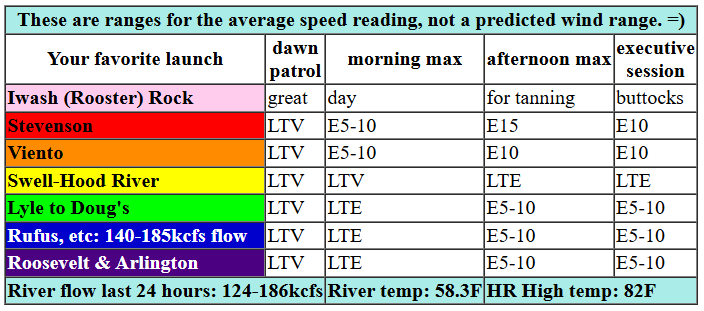
Tuesday’s a great day to rest from wind sports, because there won’t be much wind at all. Light/variable conditions this morning turn calm midday. Stevenson then picks up to 15mph this afternoon, and Iwash (Rooster) Rock rises to 10mph. From mid-afternoon on, we’ll have easterlies at 5-10mph from Hood River eastward. River flow over the last 24 hours was 124-186kcfs, river temp is 58.3F, and high temp forecast is 82F with mostly clear sky.

tomorrow’s gorge wind forecast
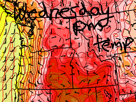
You might be fooled into thinking Wednesday will be a no wind day if you made a forecast based on initial conditions. Don’t be fooled. A trough approaching the coast shunts the hottest air into the desert. This sets us up for a strong thermal gradient in the afternoon. Morning, however, delivers a short burst of easterlies at 20-25mph at both Iwash and Stevenson – that’ll be a true dawn patrol. Easterlies will be gone by late morning. Models suggest westerlies will build to 25-28+ from Stevenson to Hood River and then to Doug’s late afternoon. They keep building; the evening session looks like 27-31 from Stevenson to Rufus. Caveat: models currently are consistent with this timing, but that doesn’t mean reality will agree. We often see the wind come in a few hours later than expected with this setup. That said, there’s room for some delay, and we should see a fun Wednesday afternoon. High temp: 89F and sunny.
extended Gorge wind forecast
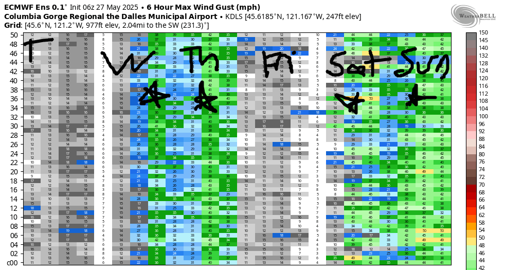
Thursday sees that trough move inland and high pressure build off the coast. This cools us down by almost 20 degrees, but still leaves plenty of cross-Cascade pressure and thermal gradient. Dawn Patrol looks like 27-31 east of The Dalles with gusty 20-23 from Stevenson to Doug’s. The current forecast calls for the Stevenson-Mosier zone to drop to 17-20 with Lyle to Arlington rising to 29-32 in the afternoon. High temp: 71F for Hood River with clouds into midday and 78F for Arlington, where it should be sunny all day.
On Friday, high pressure briefly returns and sets us up with easterlies that might be strong enough to get some of you on the river. The heat low shifts inland on Saturday, and strong, cool NW flow develops thanks to a very strong offshore high. This is a nearly-ideal setup and is likely to result in very strong west wind focused near Hood River. Models keep strong westerlies around on Sunday. The only caveat to this is some uncertainty about high temps on Saturday, which could result in a somewhat different (but almost certainly still windy) outcome. Ensembles call for westerlies of some sort to continue next Monday and Tuesday, but they’ll likely be less strong. All-in-all, I’d call that a pretty good seven days with (thankfully) some rest mixed into the picture. See you on the Nch’i Wana!
Was that helpful? I knew it was! Guess what? All of this crucial work – from your personal wind and snow reports to the invaluable TATAS updates – is made possible by my relentless efforts. Maintaining this labor of love isn’t easy. Each daily forecast takes hours. Website hosting, weather model access, and back-end admin work takes time and money. That’s where you come in.
YOUR CONTRIBUTION MAKES A DIFFERENCE
- SUPPORT ACCURATE, HYPER-LOCAL WEATHER FORECASTING
- ENABLE ACCESS FOR ALL, EVEN THOSE WITH LESS MEANS
- SUPPORT A COOL HUMAN WHO WORKS HARD SO YOU CAN PLAY
Take a moment to click one of the buttons below. Donate $19.99 or more (how much does this forecast enhance your life?) and get the email in your inbox. Whether it’s a renewing subscription (auto-renew) or a one-time donation, every contribution makes a real difference. Help me keep this labor of love alive, so we can all continue playing, commuting, and living in the Gorge with peace of mind and the best weather forecasts possible. Thank you!


Hood River, Oregon 97031


JONES BEACH, SAUVIE ISLAND, & COAST FORECAST
Wind northerly unless otherwise indicated. For coast, it’s North/Central/South with the “central” at approximately Florence. Swell forecast from NWS for central coast. Jones: westerly unless otherwise stated. Sauvie Island: northerly unless otherwise stated. Tuesday: 20/20-25/25, W swell 5′ at 10 seconds. Wednesday: W10/W10/LTV, W 5′ @ 10. Thursday: 15/20/25, W 6′ @ 11. Jones Tuesday: LTE. Wednesday: 22-25. Thursday: LTW. Sauvie Island Tuesday: 11-14. Wednesday: 15-18. Thursday: LTN.
BARE BONES HOOD RIVER WEATHER FORECAST
Mostly clear with a few clouds today. Temps start near 50 and rise to the lo w80s. Calm wind most of the day. Light easterlies in the afternoon. No rainbows. Wednesday will be clear. Temps start in the mid 50s and rise to the upper 80s. Calm wind early. Strong westerlies later. No rainbows. Thursday will be partly to mostly cloudy early and mostly clear later. Temps start in the mid 50s and rise to the low 70s. Moderately strong west wind. No rainbows.
TEMIRA’S AWESOME TRAVEL ADVISORY SERVICE – TUESDAY 5/27
HYPERLOCAL WEATHER FORECAST FOR THE COLUMBIA GORGE
THE DALLES, HOOD RIVER, WHITE SALMON, TROUT LAKE, STEVENSON, CASCADE LOCKS, PARKDALE, ODELL, HUSUM, BZ, MILL A, WILLARD, GOLDENDALE, RUFUS, ARLINGTON, boardman
Good morning, neighbors! Summer’s making a brief and intermittent visit to the Gorge. Temps will be 80+ Tuesday, Wednesday, Friday, and Sunday with much cooler days on Thursday and next Monday. Rain chances are zero-to-none most places for this period, but there’s a chance of some drizzle west of Wyeth on Wednesday morning.
Glenwood’s start and today’s Gorge weather forecast
Thanks to clear sky last night, Glenwood is starting the day at 38 degrees. And thanks to clear sky tonight, there’s a chance you’ll see the Aurora Borealis. A wee chance. Look way down low on the northern horizon. Other news today: temps rise to the low 80s. Calm wind this morning picks up to E 5-10mph all through the Gorge this afternoon with E 15mph possible near Stevenson and also in the higher exposed hills.
tomorrow’s gorge weather forecast
On Wednesday, my friends on retreat will be leaving retreat, and I’m sooooooo happy for them having had that experience, and I’m so glad they’re coming back to share that experience! Weather-wise, we’ll have sunshine, temps in the mid 50s early, and temps near 90 in the afternoon. A light wind start creates some space for spraying pesticides and also for spreading lightweight fertilizer. It’s always a bummer when the feather meal migrates downwind like a tumbleweed or a rubbish bin. As a system approaches the coast mid-afternoon, westerlies turn on. That could help temps cool off some. Wind speeds rise to 25-35mph first from Stevenson to Hood River, then to The Dalles, then to Amayah’s, the location formerly known as Biggs. Overnight, westerlies spread all the way east far into the desert, where they settle down for a cozy night with the bighorn sheep and the fast-tumbling tumbleweeds; those tumbleweeds are going to be STOKED with 30+ mph wind! Nothing makes a tumbleweed happier than tumbling.
extended gorge weather forecast
Thursday will be cooler, thank the stars. High temps max out in the low 70s to the west and upper 70s to the east. Strong west wind continues, and wind Johnnies continue scrambling around and cramming as many people into a vehicle as possible. Brief warmer weather and lighter wind returns for Friday, which could be the best day to BBQ or ride a road bike or spray or work in the garden this week. Unless you like to do so in the wind. In which case, this weekend looks great. Safe travels. -TATAS
DON’T STOP READING! Is this forecast helpful to you? Does it make you laugh, or does it improve your life? Please support the work that goes into it! It takes me a couple hours a day to write. Please join your friends and neighbors in contributing to keep it going. Venmo: @thegorgeismygym PayPal: twomirrors@gmail.com USPS: Temira / PO Box 841 / Hood River, Oregon 97031 You can test out the forecast subscription for a few days for free by signing up below. Easy! Do it!
