

GORGE WIND FORECAST
today’s gorge wind forecast
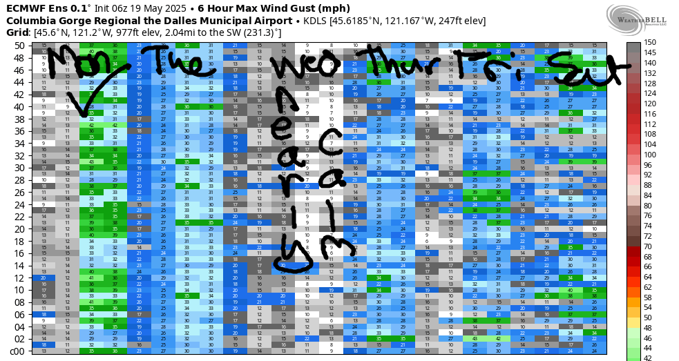
Hi friends! Hopefully you’ve enjoyed this long stretch of strong westerlies, and hopefully you’re now up for a more… relaxing… stretch of wind. Ensembles for the Gorge wind forecast have westerlies of some sort today and tomorrow. Beyond that, model agreement falls apart; ensembles generally indicate westerly flow, but with half calling for ridging and half calling for troughing, there’s no way to determine wind strength. It’s an unusually unpredictable stretch this week, for sure! Today’s looks like the windiest of the bunch, but with rain in the western Gorge, you’ll be driving for the wind.
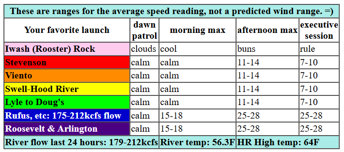
Monday started fully cloudy and drizzly in Hood River with pressures of 30.08/30.09/30.09. That’s basically flat, and the glassy river confirms it: no gradient. As a front moves through today, the eastern Gorge will be the place, and the afternoon and evening will be the time. Starting early afternoon, we’ll have 11-14 from Stevenson to Hood River with light wind from Mosier to Rufus and 15-18 from Philippi to Threemile. As that system moves through, the Rufus-Boardman zone rises to 25-28. It’s possible the wind could fill back to Avery, but models are pretty insistent that the Stevenson-Avery stretch of the Columbia will stay below 15mph and then drop below 10mph west of Doug’s in the evening. River flow over the last 24 hours was 170-209kcfs (175-212kcfs at Rufus), river temp is 56.3F, and high temp forecast is 64F for Hood River and 65F for Arlington.

tomorrow’s gorge wind forecast
Another weak disturbance on Tuesday combines with offshore high pressure for another round of west wind. Early in the day, we’ll have less than 10mph west of Avery with 19-22 from Avery to Threemile. Afternoon wind slowly builds to 17-20 from Viento to Doug’s (Stevenson will be intermittently showery and potentially a bit lighter). Between Avery and Rufus, we’re expecting 24-27 from mid-afternoon on into the evening. Arlington is a maybe; if it joins, it’ll do so a couple hours later than Rufus. East of Arlington, the wind will be lighter, perhaps 15-18mph. High temp: 62F for Hood River with showers into midday. Arlington: 64F.
extended Gorge wind forecast
High pressure briefly takes over on Wednesday and gives you a rest day. The wind will be calm or nearly so all day. Late in the evening, westerlies pick up to 10-13 from Stevenson to Swell with 5-10 in Hood River and calm conditions to the east. High temp: 69F and mostly sunny.
Beyond Wednesday, models generally indicate westerly flow, but they don’t agree on the overall setup. I can’t really make a prediction until we have more agreement, so I’ll leave it here for now. Have a great day on the Nch’i Wana!
Was that helpful? I knew it was! Guess what? All of this crucial work – from your personal wind and snow reports to the invaluable TATAS updates – is made possible by my relentless efforts. Maintaining this labor of love isn’t easy. Each daily forecast takes hours. Website hosting, weather model access, and back-end admin work takes time and money. That’s where you come in.
YOUR CONTRIBUTION MAKES A DIFFERENCE
- SUPPORT ACCURATE, HYPER-LOCAL WEATHER FORECASTING
- ENABLE ACCESS FOR ALL, EVEN THOSE WITH LESS MEANS
- SUPPORT A COOL HUMAN WHO WORKS HARD SO YOU CAN PLAY
Take a moment to click one of the buttons below. Donate $19.99 or more (how much does this forecast enhance your life?) and get the email in your inbox. Whether it’s a renewing subscription (auto-renew) or a one-time donation, every contribution makes a real difference. Help me keep this labor of love alive, so we can all continue playing, commuting, and living in the Gorge with peace of mind and the best weather forecasts possible. Thank you!


Hood River, Oregon 97031


JONES BEACH, SAUVIE ISLAND, & COAST FORECAST
Wind northerly unless otherwise indicated. For coast, it’s North/Central/South with the “central” at approximately Florence. Swell forecast from NWS for central coast. Jones: westerly unless otherwise stated. Sauvie Island: northerly unless otherwise stated. Monday: W15/W10-15/LTN, W swell 9′ at 13 seconds. Tuesday: LTW/LTNW/N25, W 10′ @ 13. Wednesday: 20/20-25/25-30, W 7′ @ 12 and S 2′ @ 18. Jones Monday: LTW. Tuesday: LTW. Wednesday: 10-13. Sauvie Island Monday: 12-15. Tuesday: LTV. Wednesday: 11-14.
BARE BONES HOOD RIVER WEATHER FORECAST
Drizzle until late morning then partly cloudy. Temps start in the upper 40s and rise to the mid 60s. Light westerlies. 94% chance of rainbows. Tuesday will be mostly cloudy with intermittent drizzle in the morning and scattered sprinkles in the afternoon. Temps start in the mid 40s and rise to the low 60s. Light westerlies early. Moderate later. 99% chance of rainbows. Wednesday will be partly cloudy then partly high clouds with filtered sun. Temps start in the low 40s and rise to the upper 60s. Calm wind most of the day. Light westerlies late. No rainbows.
TEMIRA’S AWESOME TRAVEL ADVISORY SERVICE – MONDAY 5/19
HYPERLOCAL WEATHER FORECAST FOR THE COLUMBIA GORGE
THE DALLES, HOOD RIVER, WHITE SALMON, TROUT LAKE, STEVENSON, CASCADE LOCKS, PARKDALE, ODELL, HUSUM, BZ, MILL A, WILLARD, GOLDENDALE, RUFUS, ARLINGTON, boardman

Good morning, neighbors! Unseasonably cool weather continues for a couple more days, and that’ll be accompanied by some seasonable drizzle for many of us. Seasonable right now is 68-70 degrees for Hood River, if you were wondering. Warmer, dry weather is forecast for Wednesday, and then model agreement falls apart. Generally speaking, the weather looks not-hot and not-wet through the weekend, but the details of that not-ness are not clear. Please don’t tie yourself into knots over this, unless you’re into shibari, in which case do so with a safe partner.
MONDAY’S GORGE WEATHER FORECAST & GLENWOOD’S OPENING GAMBIT
It’s Monday, and we have a friendly little weather system moving in. Open your arms and welcome it, because it’s bringing us a little rain. Models want that rain to fall as far east as Amayah’s (the location formerly known as Biggs) and also east of the Arlington Triangle until early afternoon. A short break early evening gives way to intermittent showers as far east as The Dalles all night. Temps max out in the low to mid 60s. Given that the pavement will intermittently dry out, we might get lucky and have repeated rounds of petrichor, which I just learned is caused by geosmin. That is today’s fun fact. Speaking of, I forgot to talk about Glenwood’s morning: 41 degrees and cloudy.
TUESDAY’S GORGE WEATHER FORECAST
On to Tuesday: we’ll have another round of rain! Intermittent drizzle makes it to The Dalles in the morning, and intermittent drizzle falls as far east as Hood River into the evening. Raindrops + sun breaks = rainbows. Resistance x events = suffering. Experience – reflection = missed lessons. I can’t come up a with a good one for division, so let’s move on from math. Tuesday’s temps start in the mid 40s (except in Glenwood, where light wind and -1C at 850mb makes it colder) and rise to the low 60s. Westerlies start light west of Avery with 20mph to the east. Afternoon wind rises to 15-20mph west of The Dalles and 25mph east of The Dalles.
wednesday’s gorge weather forecast
Overnight Tuesday into Wednesday, the sky turns partly cloudy and the wind goes calm. 850mb temps fall to -1C. With dewpoints along the Nch’i Wana near 40, there won’t be frost along the river. We can’t rule it out near Glenwood and maybe Centerville, where dewpoints will be lower. Parkdale: probably just fine. Down in the lowlands, temps start in the low 40s. Afternoon brings 69 degrees (the most distracting temp) with very light west wind and partly high overcast sky. Relative humidity stays relatively low. TATAS declares this a 10/10 weather day!
extended gorge weather forecast
Model agreement falls apart starting Thursday, and the temp/wind forecast range increases. Temps look somewhat warmer for the weekend when there’s slightly more agreement on ridging, but don’t make plans based on that yet; I’ve seen much better agreement morph into much more “interesting” weather many times. But don’t worry – it isn’t going to snow. I can definitely say that. Valuable Advice for Gardeners Inhabiting Neighboring Areas: I know I’ve been harping on you to plant seeds while the soil is damp, and I’m going to continue to harp on you (and hope that I too manage to plant seeds due to all this nagging). Now is the time. Seize the seeds. Take your soil temp and plant accordingly. Happy gardening. Safe travels. -TATAS
HEY! DON’T STOP READING! Is this community-focused forecast helpful to you? It sure is! It takes me a couple hours a day to write. Please join your friends and neighbors in contributing to keep it going. Venmo: @thegorgeismygym PayPal: [email protected] USPS: Temira / PO Box 841 / Hood River, Oregon 97031 You can test out the forecast subscription for a few days for free by signing up below. Easy! Do it!

Leave a Reply