

GORGE WIND FORECAST
today’s gorge wind forecast
Hi friends! Reality totally under-performed the models and the Gorge wind forecast yesterday except for a shorter-than-expected strong blast ahead of the cold front. I think I understand what went wrong with the forecast and improve it going forward, so that’s an okay outcome by my book. Hopefully y’all got on the water even though the wind wasn’t as strong as expected. Thank goodness for all the new sports that are super-fun in gusty, lighter wind! Most of the next 7 days (exception: today) will have enough wind to get many of you on the river. And today, if you move quick enough, has a morning session for you. Models have honed in on next Tuesday as the biggest of days (especially out east) with a much more ideal setup driving the wind. This Saturday also looks relatively strong, but not huge. Let’s take a look, shall we?
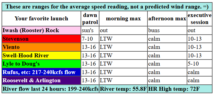
Thursday started with a pretty sunrise and pressures of 30.30/30.24/30.21 for gradients of 0.06/0.03. Those gradients will drop quickly as temps and pressures equalize across the Cascade crest today. While the day started with 13-16ish most places, calm wind is expected by mid morning with just 7-10mph this evening between Stevenson and Mosier. Rest up, friends! River flow over the last 24 hours was 199-240kcfs (217-240kcfs at Rufus), river temp is 55.8F, and high temp forecast is 72F with mostly sunny sky.

tomorrow’s gorge wind forecast
Friday starts dead calm. By late morning, we’ll have 14-17 from Stevenson to Mosier. Afternoon wind rises to 16-19 from Stevenson to Hood River with 18-21 from Mosier to Avery and 14-17 near Rufus. High temp: 79F with plenty of high clouds.
extended Gorge wind forecast
An offshore low moves towards BC Saturday morning as high pressure builds off the Oregon coast. Wind aloft will be SW switching to W, which means the wind is likely to under-perform models some for the morning. Dawn Patrol looks like 17-21 from Stevenson all the way to Arlington. Westerlies build to 21-24 near Hood River for a couple hours early morning before dropping to 15-18 for much of the day and surging back at 20-23 late in the day. The main action will be east of Hood River on Saturday: Afternoon wind rises to 26-29 from Lyle to Arlington with 23-26 at Threemile. High temp: 71F with partly high overcast sky and mid-level clouds for the western Gorge in the evening.
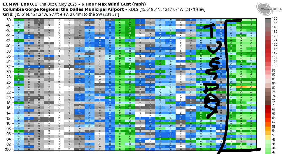
Drizzle on Sunday morning gives way to a dry afternoon. Thanks to low pressure offshore, wind will be more thermally/frontally driven. We’re probably looking at 20-23 or a bit more. Offshore high pressure returns for Monday and Tuesday with reality likely to outperform the models on Monday afternoon and Tuesday all day. Tuesday looks especially promising as wind aloft is forecast to be in the NW 40 range, an excellent setup for the Rufus area and beyond. While the GFS is over-performing the Euro ensembles at this point with a forecast of 35mph, even the ensembles are suggesting 28-32mph. Naturally – I have a midday appointment in Portland on Tuesday! All-in-all, the next seven days look great for wind sports. With cooler temps and even some rain in the cards early next week, mountain biking and gravel biking also look good. Let’s play!
Was that helpful? I knew it was! Guess what? All of this crucial work – from your personal wind and snow reports to the invaluable TATAS updates – is made possible by my relentless efforts. Maintaining this labor of love isn’t easy. Each daily forecast takes hours. Website hosting, weather model access, and back-end admin work takes time and money. That’s where you come in.
YOUR CONTRIBUTION MAKES A DIFFERENCE
- SUPPORT ACCURATE, HYPER-LOCAL WEATHER FORECASTING
- ENABLE ACCESS FOR ALL, EVEN THOSE WITH LESS MEANS
- SUPPORT A COOL HUMAN WHO WORKS HARD SO YOU CAN PLAY
Take a moment to click one of the buttons below. Donate $19.99 or more (how much does this forecast enhance your life?) and get the email in your inbox. Whether it’s a renewing subscription (auto-renew) or a one-time donation, every contribution makes a real difference. Help me keep this labor of love alive, so we can all continue playing, commuting, and living in the Gorge with peace of mind and the best weather forecasts possible. Thank you!


Hood River, Oregon 97031


JONES BEACH, SAUVIE ISLAND, & COAST FORECAST
Wind northerly unless otherwise indicated. For coast, it’s North/Central/South with the “central” at approximately Florence. Swell forecast from NWS for central coast. Thursday: 20-25/20-25/20, W swell 6′ at 11 seconds. Friday: 10-15/10-15/15-20, W 5′ @ 11. Saturday: LTW/LTW/N10-15, W 4′ @ 10. Jones Thursday: 12-15. Friday: 18-21. Saturday: LTW. Sauvie Island Thursday: 11-15. Friday: 10-13 > 5pm. Saturday: 15-18.
BARE BONES HOOD RIVER WEATHER FORECAST
Thursday will have a few high clouds, then clear sky, then high clouds again. Temps start in the upper 40s and rise to the low 70s. Light west wind early. Calm midday. Light westerlies later. No rainbows. Friday will be partly high overcast all day. Temps start in the mid 40s and rise to the upper 70s. Calm wind early. Moderate westerlies later. No rainbows. Saturday will be high cloudy with some mid-level clouds late. Temps start near 50 and rise to the lo 1ow 70s. Moderately strong westerlies. No rainbows.
TEMIRA’S AWESOME TRAVEL ADVISORY SERVICE
HYPERLOCAL WEATHER FORECAST FOR THE COLUMBIA GORGE
THE DALLES, HOOD RIVER, WHITE SALMON, TROUT LAKE, STEVENSON, CASCADE LOCKS, PARKDALE, ODELL, HUSUM, BZ, MILL A, WILLARD, GOLDENDALE, RUFUS, ARLINGTON, boardman
Good morning, neighbors! A few more days of 70+ degree weather are in the cards. Starting Sunday, temps drop back into the 60s as a pattern change gives us more clouds and even a chance of a little rain. Best chance for widespread rain: Sunday. More deets on that in a bit.
glenwood
Before we dive into the forecast, we’ll dive in bed with Glenwood, where an extra blanket is in order this morning to hide your muff-diving from prying eyes: 32 degrees there in good old Glenwood. Lingering westerlies spared the rest of us from a frost this morning, thankfully, as I’ve planted tomatoes despite the lingering snow on Mt. Defiance.
No snow is forecast this upcoming week, you’ll be happy to know. However, you could go up to Timberline and Meadows where there’s plenty. Meadows was 27 degrees this morning.
today’s gorge weather
Today’s weather (it’s Thursday) will be nothing short of glorious. The wind goes calm midday and only rises to 5-10mph out of the west and only west of Mosier this afternoon. Temps max out right around 70 degrees, which qualifies for a 10/10 rating from TATAS. Just enough high clouds return for the evening to give some bonus color to the sunset. All-in-all: awesome weather.
friday’s gorge weather
Friday will be too warm for TATAS to call it awesome: right around 80 degrees all through the lowlands. It’s too hot for TATAS, but it won’t ‘be too hot to bare your tatas, hoo-has, and ding-dongs to the sun at the Iwash Rock nude beach. While the day starts with calm wind, it finishes with 15-20mph between Stevenson and Rufus, where you can get a huge steak and top it with Gongora Lamb from down the road at Amayah’s. That’s what I call “Meat Breakfast”, which is also the name of a large, orange-yellow tomato from the Ukraine that I’m growing in my garden this summer. Back to Friday’s weather… there should be enough high clouds all day long to color the sky at sunrise and sunset. Enjoy!
saturday’s gorge weather
Weather stuff on Saturday knocks high temps back to 70 and drives stronger west wind: 15-20mph from Stevenson to Arlington to start. Afternoon wind: 20-25mph west of Mosier and 25-30mph east of Mosier all the way to Threemile Canyon and beyond. Once again, we’ll have scattered high clouds in the morning and evening for extra-lovely sky. I say “extra-lovely” because the sky is beautiful all day and all night. If we didn’t have sky, it’d mean we didn’t have an atmosphere, and then we’d all be dead which would suck.
sunday’s (potentially wet) Gorge weather and the extended forecast
On Sunday, something very, very exciting is in the forecast: rain! We’re not talking east coast downpour here, but we are expecting at least a little drizzle most places. If you see someone twerking doggy style naked in the rain with a huge grin on their face, it’s probably me. Please respect my privacy by not posting pictures of me being inappropriately joyful. Looking past my naked, dancing, jiggling buttocks and into next week, we see cooler high temps (60 degrees or so) for at least several days. Drizzle chances continue on and off for the western parts of the Gorge. With this setup, this time of year, west wind is likely to continue day in and day out. Tuesday looks especially strong, so you can mark that one off the “spray, baby spray” and burn pile calendars. Valuable Advice for Gardeners Inhabiting Neighboring Areas: yesterday I spotted 6” tall pole bean volunteers in my garden. Apparently it’s time to plant those. In addition, the cool, damp weather next week will aid germination, or at least aid keeping those seedlings watered. Now’s the time to get all those seeds in the ground. Happy planting. Safe travels. -TATAS
HEY! DON’T STOP READING! Is this community-focused forecast helpful to you? It sure is! It takes me a couple hours a day to write. Please join your friends and neighbors in contributing to keep it going. Venmo: @thegorgeismygym PayPal: [email protected] USPS: Temira / PO Box 841 / Hood River, Oregon 97031 You can test out the forecast subscription for a few days for free by signing up below. Easy! Do it!

Leave a Reply