

MT HOOD WEATHER FORECAST
Good morning skiers and snowboarders! It’s Tuesday. Today’s Mt Hood weather: awesome powder skiing with a chance of bluebird! Resorts picked up about 10” of fresh dry powder last night. A couple more inches are in the cards today. We then fall into a brief dry spell through Wednesday afternoon, and then it’s right back to accumulating snow. Signs are positive for lots of snow Friday afternoon into Saturday morning. Models have us mostly dry Saturday, and then they’re split for Sunday. Most likely scenario seems to be a snowy start and rainy finish. That’s followed by a few days of warm, dry weather to start next week. All right… let’s talk powder!
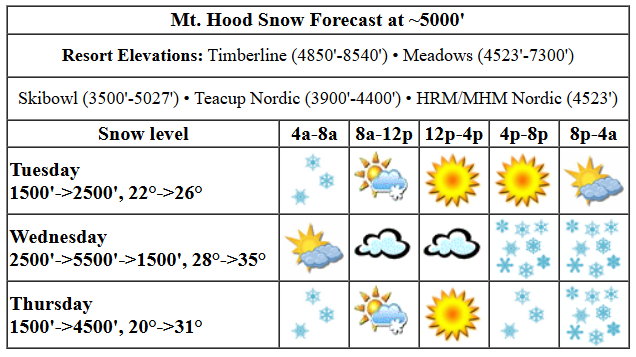
Tuesday’s got some nice blower pow on the ground for you. Get up there and get it! The snow level starts around 1500′ this morning and rises to 2500′ this afternoon. Temps at 5000′: 22F this morning and 26F this afternoon. We’re expecting 0.1” to 0.2” water equivalent (WE) this morning prior to the sun coming out. That’s 1-2” additional powder. Clouds return this evening. Wind today will be WNW 20-25 this morning, W 15 this afternoon, and SSW 10-15 overnight.
Dry, overcast weather is the call Wednesday daytime. Snow returns late afternoon or early evening. The freezing level will be 2500′ in the morning, 5500′ in the afternoon, and then the snow level will plunge back to 1500′ overnight. Temps start in the upper 20s, rise to the mid 30s, and fall back to the mid 20s overnight. About 0.3” WE is forecast for about 3” of initially dense, then lighter snow. Wind: SSW 10-15 in the morning, S 15-30 in the afternoon, SW 25-40 in the evening, and W 45 overnight. That strong west wind could increase snow total by up to 50%.
Snow flurries Thursday morning alternate with some sun breaks. This gives way to steady snow in the afternoon and heavy snow overnight. The snow level starts around 1500′, rises to 2500′ in the afternoon, and climbs to 4500′ overnight. Temps start near 20F and slowly climb to the low 30s after midnight. A trace of snow is forecast in the morning, a couple inches in the afternoon, and 0.7” WE for 4-6” dense new snow overnight. Wind will be W 45 early, WS 30 mid-morning, SW 25-35 in the afternoon, and W 45 after midnight. The strong overnight wind could up the snow totals.
extended mt hood weather forecast
Heavy to very heavy snowfall is forecast Friday with the snow level starting at 4500′ and eventually falling to 1500′. Saturday, as of this morning, looks mostly dry. Snow and potentially rain are forecast for Sunday. After that: warm, sunny weather for a few days before we plunge right back in to winter. Have a great powder day today!
Was that helpful? I knew it was! Guess what? All of this crucial work – from your personal wind and snow reports to the invaluable TATAS updates – is made possible by my relentless efforts. Maintaining this labor of love isn’t easy. Each daily forecast takes hours. Website hosting, weather model access, and back-end admin work takes time and money. That’s where you come in.
YOUR CONTRIBUTION MAKES A DIFFERENCE
- SUPPORT ACCURATE, HYPER-LOCAL WEATHER FORECASTING
- ENABLE ACCESS FOR ALL, EVEN THOSE WITH LESS MEANS
- SUPPORT A COOL HUMAN WHO WORKS HARD SO YOU CAN PLAY
Take a moment to click one of the buttons below. Donate $19.99 or more (how much does this forecast enhance your life?) and get the email in your inbox. Whether it’s a renewing subscription (auto-renew) or a one-time donation, every contribution makes a real difference. Help me keep this labor of love alive, so we can all continue playing, commuting, and living in the Gorge with peace of mind and the best weather forecasts possible. Thank you!


Hood River, Oregon 97031


GORGE WIND FORECAST

Hi friends! Congrats to those of you who got out on the river yesterday. There isn’t a whole lot forecast for the next five days, so yesterday’s session will have to hold you. Today starts with pressures of 30.27/30.21 for 0.06 (pdx-dls). A few spots were reading in the teens prior to dawn. We’ll see less than 15mph to start the day. Westerlies bump up to 14-17mph from Stevenson to Arlington mid-morning as a system clears the area. We could see Avery to Rufus rise to 18-22 this afternoon, but in the same time period, areas west of Avery drop to 10-13. River flow over the last 24 hours was 111-175kcfs, river temp is 43.7F, and high temp forecast is 50F with drizzle early and partly cloudy sky the rest of the day.
Wednesday brings easterlies. They peak at 25mph at both Iwash (Rooster) Rock and Stevenson by mid-morning. Stevenson holds until late afternoon, but Iwash will be dropping throughout the day. After 5pm, the wind turns westerly as the next weather system arrives and a compact low swings into the desert. It’s possible we’ll see surprise burst ahead of this incoming system, but the models are not optimistic about anything happening at the Hatch. High temp: 50F with overcast sky all day. Thursday brings lingering westerlies from Wednesday night’s action. The day starts with 10mph west of Maryhill and gusty 22-26 from Maryhill to Boardman. The wind holds in the low 20s out east until late afternoon. The Rowena area likely joins mid-afternoon. West of Lyle, the wind peaks at 10-13mph. High temp: 50F with rain early, dry weather midday, and rain in the afternoon. Models are not optimistic about wind for the Friday-Sunday period. Break out some alternate sports. Have fun!
BARE BONES HOOD RIVER WEATHER FORECAST
Rain early. Partly cloudy the rest of the day. Temps start near 40 and rise to 50 or so. Moderate westerlies. 12% chance of rainbows. Wednesday will be dry and overcast. Temps start in the mid 30s and rise to 50. Light to moderate easterlies. No rainbows. Thursday will be drizzly early, dry much of the day, and rainy in the evening. Temps start in the upper 30s and rise to 50. Moderate westerlies. 99% chance of rainbows.
TEMIRA’S AWESOME TRAVEL ADVISORY SERVICE
HYPERLOCAL WEATHER FORECAST FOR THE COLUMBIA GORGE
THE DALLES, HOOD RIVER, WHITE SALMON, TROUT LAKE, STEVENSON, CASCADE LOCKS, PARKDALE, ODELL, HUSUM, BZ, MILL A, WILLARD, GOLDENDALE, RUFUS, ARLINGTON, boardman
Good morning, neighbors! We have another gorgeous day on tap, and this one’s looking perfect for a constitutional crisis. What’s that, you ask? Well, the current version is when the courts say “do this”, and the executive branch says, “F you I won’t do what you tell me.” It’s a bit like me telling you what the weather will do, and the weather refusing to cooperate. Oh, wait, I don’t control the weather. That’s NOAA. Well anyway… on tap for the next week or so are dry periods interspersed with wet periods as spring does spring. Models still insist on warm weather next Monday, Tuesday, and Wednesday – temps could reach 70 degrees.
All I need is a bikini for my first FULL BUSH IN A BIKINI of 2025. Bring it on!
today + glenwood
Glenwood kicks off today at 29 degrees, tying the higher elevations of Parkdale for the morning cold spot. It’s way too cold for a bikini this morning. If you’re out and about, watch out for black ice anywhere with clear sky and light wind. For the rest of today, we’ll see partly cloudy sky (yes, even those of you still in the clouds and drizzle near Cascade Locks) and westerlies at 15mph or so. Temps max out near 50. High clouds arrive overnight.
Looking to vent today? Jeff Merkley has a town hall in Boardman at 11:30am, one in Arlington at 2pm, and one in Wasco at 5pm. That dude has some serious energy and endurance. Can you imagine putting yourself out there three times in one day to get yelled at by a bunch of unhappy constituents? Bravo, Senator.
wednesday
High clouds stick around Wednesday before finally thickening enough in the evening to drop rain starting around 5pm. The rain extends to Lyle all night long and makes it all the way to the Tri-Cities for a few hours late evening. Temps in the lowlands max out near 50. Wind will be E 25mph near Iwash and Stevenson all day. In the evening, it turns westerly with the arrival of the rain. Overnight, the snow level drops to 1500′. 1-2” snow is possible in Willard, Mill A, Trout Lake, Parkdale, York Hill, Underwood, and possibly Snowden.
thursday
Rain early Thursday gives way to dry weather midday and rain in the evening all the way east to Arlington. SW/Sherm: you too get some rain out of this. Models take the snow level above 2000′ in the evening, so we probably won’t have any issues locally from snowfall. Up on the passes: lots of snow. Definitely winter travel conditions. I guess this is a good time to start thinking about the studs needing to get off, I mean be removed, by 4/1. Temps max out around 50 degrees on Thursday. Westerlies will be 10mph west of The Dalles and 20-25mph to the east.
friday and beyond
Friday looks quite wet near Cascade Locks and damp as far east as The Dalles. Saturday: probably dry. Sunday: moist to very moist west of Rowena. Monday, Tuesday, and Wednesday currently look warm and sunny. That is all for now. Safe travels. -TATAS
HEY! DON’T STOP READING! Is this community-focused forecast helpful to you? It sure is! It takes me a couple hours a day to write. Please join your friends and neighbors in contributing to keep it going. Venmo: @thegorgeismygym PayPal: [email protected] USPS: Temira / PO Box 841 / Hood River, Oregon 97031 You can test out the forecast subscription for a few days for free by signing up below. Easy! Do it!

Leave a Reply