

MT HOOD WEATHER FORECAST
Hey skiers and snowboarders! Today’s going to be one heck of a groom day – it’ll be cold, dry packed powder all across the land. Then the Mt Hood weather takes a turn for the snowier; we’ll pick up another half a foot of snow tonight into tomorrow. That’s followed by flurries on Tuesday, dry weather Wednesday daytime, and another round of heavy snowfall Wednesday night into Friday. All that should be nice cold pow as the snow level stays below 3000′ while it’s snowing. Somewhat warmer snowfall is in the cards Friday. Knowing that things could change, we can still take a glance at next weekend: probably dry on Saturday with wet, heavy snowfall on Sunday, potentially turning to rain late in the day. After that: warmer weather with a few potentially warm, sunny days on tap to start the following week.
today’s issues
Before we dive in: Meadows is still experiencing power issues today. HRM, Heather, and Nordic are out of the picture, which means no gated terrain today. At all the resorts, you can expect ongoing storm recovery as staff works to dig out lifts and terrain park features. Be kind to them – they’ve been busting butt for days!
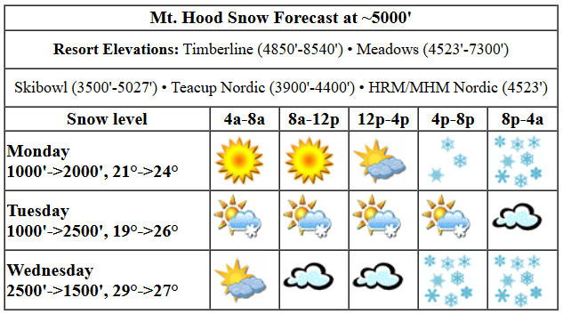
It’ll be good digging weather daytime today as the sun sticks around for the first half of the day. Snow conditions: packed powder. The free air freezing level will be around 1000′ this morning and 2000′ this afternoon. Temps at 5000′ will be in the low 20s early and will rise a couple degrees thanks to the strong March sun this afternoon. When snow arrives tonight, the snow level will be around 1500′. We’re expecting perhaps an inch of new snow prior to 5pm thanks to instability ahead of the next system. Overnight, models call for 0.4” to 0.5” water equivalent (WE) for 4-6” dry powder. Wind will be NW 15-20 all morning, WNW 20-25 this afternoon, and NW 25-30 overnight.
Intermittent flurries are forecast on Tuesday with dry weather overnight. The snow level will be around 1500′ in the morning, 2000′ in the afternoon, and 2500′ after midnight. Temps will be in the low 20s in the morning and around 27F in the afternoon. Just an inch of so of snow is expected. Wind will be NW 25-30 in the morning, SW 10-20 in the afternoon, and S 10-20 overnight.
Dry, high overcast weather Wednesday morning gives way to heavy snow overnight. The snow level will be 2500′ in the morning, 3500′ in the evening, and it’ll fall as low as 1500-2000′ after midnight. Temps start in the upper 20s, rise briefly to 24F or so, and fall back to 27F or so after midnight. About 0.9” WE is forecast overnight for 9-11” new snow or decent quality. Wind: S 10-20 most of the day becoming WSW 50-55 in the evening and W 45 after midnight. Orographics associated with all that wind could increase snow totals by 20-30%.
extended mt hood weather forecast
Heavy snow continues on Thursday with up to a foot expected in the 24 hour period. It definitely looks like a storm skiing day with strong westerlies. Temps will be in the upper 20s at 5000′. Another round of heavy moisture, slightly warmer perhaps, is forecast Friday. Saturday could be dry or nearly so. Models are hinting at heavy, slowly warming precip next Sunday, but not all members are on board with that. Let’s leave this here by saying this: there’s a lot of snow in the forecast in the next week. See you on the slopes!
Was that helpful? I knew it was! Guess what? All of this crucial work – from your personal wind and snow reports to the invaluable TATAS updates – is made possible by my relentless efforts. Maintaining this labor of love isn’t easy. Each daily forecast takes hours. Website hosting, weather model access, and back-end admin work takes time and money. That’s where you come in.
YOUR CONTRIBUTION MAKES A DIFFERENCE
- SUPPORT ACCURATE, HYPER-LOCAL WEATHER FORECASTING
- ENABLE ACCESS FOR ALL, EVEN THOSE WITH LESS MEANS
- SUPPORT A COOL HUMAN WHO WORKS HARD SO YOU CAN PLAY
Take a moment to click one of the buttons below. Donate $19.99 or more (how much does this forecast enhance your life?) and get the email in your inbox. Whether it’s a renewing subscription (auto-renew) or a one-time donation, every contribution makes a real difference. Help me keep this labor of love alive, so we can all continue playing, commuting, and living in the Gorge with peace of mind and the best weather forecasts possible. Thank you!


Hood River, Oregon 97031


GORGE WIND FORECAST

Hi friends! Nice seeing all of you on the river yesterday. Maybe someone put out a memo, because there were quite a few more people than there have been lately despite the river temp still being right around 40 degrees. The next best chance for enough west wind to get you on the river is Thursday with a somewhat lesser chance on Friday. Tuesday kicks off with light offshore gradient, but the wind will turn light westerly this afternoon. After 2pm, you’ll find W 11-14 from Iwash to Viento or maybe to Swell, light wind from Hood River to Doug’s, and gusty 18-22 from Avery to Rufus. Arlington joins after 4pm with 13-16. River flow over the last 24 hours was 97-157kcfs, river temp is 40.28F, and high temp forecast is 50F with drizzle through early afternoon as far east as Boardman.
Not much happens Wednesday. The day starts nearly calm. Easterlies pick up to 10mph at Iwash (Rooster) Rock and 10-15mph at Stevenson before dropping to 10mph at both locations after 1pm. High temp: 52F and mostly clear. Models currently call for west wind on Thursday afternoon as a low move along the OR-CA border and into Idaho. As of this morning, models suggest 15-18 from Stevenson to Mosier, light wind in the Lyle stretch, and 20-23 from Avery to Arlington. Lingering westerlies are possible near the Hatch on Friday morning. Weekend: not much in the cards in any of the ensemble members. Have a great day today, everyone!
BARE BONES HOOD RIVER WEATHER FORECAST
Partly cloudy sky today with rain late afternoon. Temps start in the low 40s and rise to the upper 40s. Moderate to moderately strong westerlies. No rainbows. Tuesday will be mostly cloudy with showers to start and partly cloudy with showers later. Temps start in the mid to upper 30s and rise to the upper 40s. Light to moderate westerlies. 99% chance of rainbows. Wednesday will be high overcast with rain in the evening. Temps start in the mid 30s and rise to the upper 40s. Light to moderate easterlies. 1% chance of rainbows.
TEMIRA’S AWESOME TRAVEL ADVISORY SERVICE
HYPERLOCAL WEATHER FORECAST FOR THE COLUMBIA GORGE
THE DALLES, HOOD RIVER, WHITE SALMON, TROUT LAKE, STEVENSON, CASCADE LOCKS, PARKDALE, ODELL, HUSUM, BZ, MILL A, WILLARD, GOLDENDALE, RUFUS, ARLINGTON, boardman
Good morning, neighbors! I’m running a bit behind this morning after having a very good night of sleep last night. Yay. Generally speaking, we have a wet seven days on tap. Models still insist on warm weather the 24th through the 26th. Definitely looking forward to that – suns out guns out suns out buns out full bush in a bikini!
glenwood and the tatas eootd
But not today. Let’s check in with Glenwood. I forgot yesterday. Glenwood starts the day mostly sunny and 30 degrees. So, that means we’ll have icy roads out and about today especially in clear-sky areas. TATAS Executive Order Of The Day: Free pre-K education for all kids!
today (it’s monday)
Weather today: partly cloudy this morning to the west and sunny to the east. A system arrives this afternoon, and so does instability. It’s possible we could see heavy showers and a thunderstorm or two even out in the desert. Driving back from the metro area this afternoon or early evening? You’ll encounter moderately heavy rain to Hood River and light rain to Lyle. Today’s wind picks up to 15-20mph west of Lyle and 20-30mph east of Lyle to Boardman. High temp: close enough to 50 degrees to just call it 50 degrees. Overnight, the snow level will be around 1500′; Parkdale, York Hill, Underwood, and Trout Lake could pick up 1/2” to 2” with the highest amounts near Parkdale.
tuesday
Intermittent showers are forecast all day Tuesday as far east as Hood River. Early and late, The Dalles could see some showers. Up high, those could be snow flurries, but no accumulation is expected. Wind will be less than 10mph west of Arlington in the morning. Afternoon wind rises to 10-15mph west of Lyle and 15-20mph from Lyle to Boardman. Let’s call it 50 degrees for a high again.
wednesday
Dry weather Wednesday morning gives way to heavy rain in the evening, just in time for your drive home from the metro area, as far east as Hood River. Lighter rain extends to The Dalles. We’ll be keeping a close eye on the snow level overnight – it’s possible our highest spots could pick up wet snow thanks to the overnight timing and evaporative cooling. Know how your nights can get hot sometimes? The planet prefers to cool things off. Just telling you in case you hadn’t heard that before! High temp Wednesday: a couple degrees below 50. Wind: easterly at 25mph in the usual spots (cock rock, for example) and 10-15mph everywhere else.
extended gorge weather forecast
Wet weather continues Thursday and Friday. We could see a break on Saturday, but that’s probably going to be followed by wet weather Sunday. Models then insist on three days of warm weather. But wait. Not all those models call for dry weather. FFS, it’s time we had some 60-70 degree sunshine! Safe travels. -TATAS
HEY! DON’T STOP READING! Is this community-focused forecast helpful to you? It sure is! It takes me a couple hours a day to write. Please join your friends and neighbors in contributing to keep it going. Venmo: @thegorgeismygym PayPal: twomirrors@gmail.com USPS: Temira / PO Box 841 / Hood River, Oregon 97031 You can test out the forecast subscription for a few days for free by signing up below. Easy! Do it!
