

MT HOOD WEATHER FORECAST
Hey skiers and snowboarders! High pressure keeps us (mostly) dry and on the warm side all the way through Monday. After that, models really like the idea of a week of cold, wet Mt Hood weather with anywhere from 2-5” total water equivalent. Let’s all vote for several feet of snow next week! Between now and then: lots of days to cruise the groom, skate the corduroy, and work on your goggle tan (which is a hard thing to explain to your boss if you skipped work to shred). Today’s snow surface, thanks to a couple inches of new yesterday, is shallow packed powder over granular up high, and mostly granular down low.
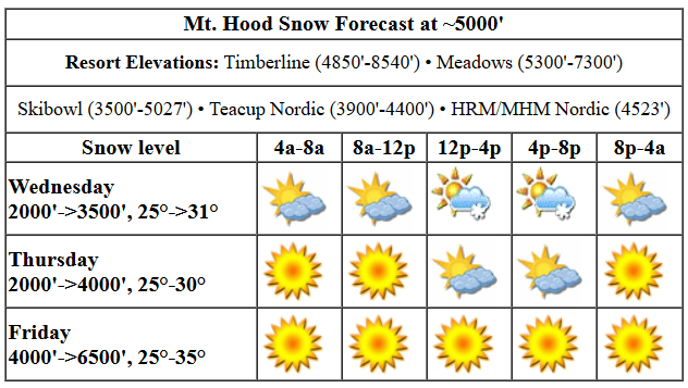
Wednesday starts partly cloudy. We’ll see clear sky later and then a chance of some instability-driven snowfall in the afternoon and early evening. The snow level will be 2000′ this morning, 3500′ this afternoon, and 2000′ after midnight. Maybe an inch or so of snow is possible, but don’t be surprised of we get none. Temps will be in the mid 20s early and low 30s in the afternoon. Wind: SW 5-10 this morning turning to NE 10 this afternoon and holding overnight.
Thursday starts mostly clear with potentially a few high clouds. Some little fluffy clouds pop up in the afternoon thanks to instability driven by a low zooming inland well to the south. Precip is unlikely. The free air freezing level will be around 1500′ to start and will rise to 4000′ in the afternoon. It holds overnight. That gives us temps in the mid 20s in the morning and low 30s in the afternoon. Wind: NE 10-15 in the morning, WNW 20-25 in the afternoon, and NNW 15-20 after midnight.
Friday will be sunny in the morning with filtered sun in the afternoon. The free air freezing level will be 4000′ most of the day and will rise to 6500′ overnight. Temps start in the mid 20s and rise to the low-mid 30s. Wind: NNW 15-20 all day and SW 10-20 after midnight.
Above-freezing, sunny weather is forecast on Saturday and Sunday. Temps will max out between 35-40F both days, so wax warm for the conditions. We should have granular snow by then, which means we’ll have frozen granular in the morning and corn snow in the afternoon. With temps staying at least somewhat cool, the snow should last longer than it did in our last warm period.
This pattern breaks down late Monday or early Tuesday. Models brings us a lot of precip with cool-enough temps through next week. Fingers crossed for lots of snow! See you out there!
Was that helpful? I knew it was! Guess what? All of this crucial work – from your personal wind and snow reports to the invaluable TATAS updates – is made possible by my relentless efforts. Maintaining this labor of love isn’t easy. Each daily forecast takes hours. Website hosting, weather model access, and back-end admin work takes time and money. That’s where you come in.
YOUR CONTRIBUTION MAKES A DIFFERENCE
- SUPPORT ACCURATE, HYPER-LOCAL WEATHER FORECASTING
- ENABLE ACCESS FOR ALL, EVEN THOSE WITH LESS MEANS
- SUPPORT A COOL HUMAN WHO WORKS HARD SO YOU CAN PLAY
Take a moment to click one of the buttons below. Donate $19.99 or more (how much does this forecast enhance your life?) and get the email in your inbox. Whether it’s a renewing subscription (auto-renew) or a one-time donation, every contribution makes a real difference. Help me keep this labor of love alive, so we can all continue playing, commuting, and living in the Gorge with peace of mind and the best weather forecasts possible. Thank you!


Hood River, Oregon 97031


GORGE WIND FORECAST

Hi friends! Not much happens today, but if you’re Walker, the following two days will be “nuking”. For the rest of us, it might be just enough, and probably will be focused on the Lyle-Doug’s stretch. Wednesday starts with a light east gradient, just 0.02. Easterlies pick up to 10mph or so near Stevenson, and only near Stevenson, for a couple hours midday. They drop below 10mph in the afternoon. River flow over the last 24 hours was 100-173kcfs, river temp is 40.28F, and high temp forecast is 52F with clouds in the morning and mostly clear sky later.
Thursday starts calm, but picks up later as high pressure builds (briefly) offshore and a low moves into Idaho. By late morning, we should have gusty 17-20 from Stevenson to Viento with gusty 20-23 from Swell to Doug’s and 11-14 out east. Late in the day, Stevenson to Swell drops to 17-20, and Mosier to Avery rises to 21-24. Out east: holding in the teens, at best. High temp: 55F and sunny. Friday sees another round of moderate west wind. With all sorts of movement offshore, the wind is likely to be inconsistent. That said, let’s call it 18-22 form Stevenson to Mosier to start with a chance of higher speeds for Dawn Patrol thanks to offshore high pressure. That high pressure fades, but we’ll see a little thermal assistance. From mid-morning on, we’ll have 15-18ish from Stevenson to Swell, 19-22 from Mosier to Rufus, and 15-18 east of Rufus to Arlington. High temp: 54F with partly cloudy sky in the morning and partly high overcast sky later.
BARE BONES HOOD RIVER WEATHER FORECAST
Clouds this morning. Partly cloudy this afternoon. Temps start in the upper 30s and rise to the low 50s. Very light east wind. No rainbows. Thursday will be partly Nothing then clear. Temps start in the low-mid 30s and rise to the mid 50s. Calm wind early. Moderate westerlies later. No rainbows. Friday will be partly cloudy then partly high overcast. Temps start in the mid 30s and rise to the mid 50s. Moderate westerlies. No rainbows.
TEMIRA’S AWESOME TRAVEL ADVISORY SERVICE
HYPERLOCAL WEATHER FORECAST FOR THE COLUMBIA GORGE
THE DALLES, HOOD RIVER, WHITE SALMON, TROUT LAKE, STEVENSON, CASCADE LOCKS, PARKDALE, ODELL, HUSUM, BZ, MILL A, WILLARD, GOLDENDALE, RUFUS, ARLINGTON, boardman

Good morning, neighbors! Not much happens this week other than some real nice weather for getting shit done outside. By shit, I specifically mean moving shit into your (my) garden. We should be dry through Sunday and potentially Monday. After that: cooler and wetter with a few snow flurries out and about and lots of snow on the mountain passes.
Let’s first say good morning to Glenwood: It’s 28 degrees, partly high overcast, and the dewpoint is 23F. TATAS Executive Order Of The Day: Protesting is legal and always shall be legal. Protesting using violence is not legal and never has been legal. Speaking of protesting, there’s a demonstration for women’s rights on International Women’s Day (Saturday) at the bottom of the Second Street Stairs in Hood River. That’s right across from Pure Stoke, so plan to make some purchases there that day.
wednesday
On to Wednesday. We have a bit of a Nothing to start with some high clouds above it. Models give us some high clouds out and about today, all day. We’ll finish up in the low 50s along the river today with very light east wind, light enough we really don’t need to dive into the details.
Thursday
Overnight, we’ll have mostly clear sky. That’ll send those of you in away from the Nch’i Wana (Big River) below freezing Thursday morning. With 850mb temps at -3C, it’ll be quite chilly, perhaps 20F or so, in Glenwood. In the afternoon, temps rise to the mid 50s (WARM!) along the Big River. Calm wind early (is it time for “spray, baby, spray” yet?) pick up to 15-25mph from Stevenson to Avery in the afternoon.
friday
With lingering westerlies overnight, temps will stay above freezing on the river. We’ll also have some low clouds from Hood River westward to start Friday. Away from the river, those of you in the clear-sky areas (east of Underwood, maybe, will have a frosty start. Westerlies start the day at 15-25mph and hold. They’ll extend as far east as Amayah’s Indian Curry and Kababs (the location formerly known as Biggs Junction) with 15-20mph near the Arlington Triangle (soon to be home of some massive data center for the evil Google conglomerate).
weekend
On to the weekend: warm and sunny with temps in the upper 50s on Saturday and low 60s on Sunday. Spray, baby, spray! Poop, horsies, poop! I’m coming for your poop, so you better poop it up! Humans: enjoy this warm and sunny weekend. Sometime in that Monday-Tuesday window, the ridge falls apart (following in the footsteps of our democracy) and colder, wetter weather moves in. Models are uncertainty how much moisture we’ll get next week, but they’re damned certain there will be some.
Valuable Advice for Gardeners Inhabiting Neighboring Areas
Valuable Advice for Gardeners Inhabiting Neighboring Areas: with damp soil in place, warm weather forecast, and rain next week, now’s a good time to toss some peas and lettuce and stuff in the ground. It’s also time to start your peppers. If you’re foolish, like I am, it’s time to start your tomatoes, but really you should wait until March 15th for that. But hey, I’m going to be gone all of April, so I had to do it already. Is 75 varieties too many? Happy gardening. Safe travels. -TATAS
HEY! DON’T STOP READING! Is this community-focused forecast helpful to you? It sure is! It takes me a couple hours a day to write. Please join your friends and neighbors in contributing to keep it going. Venmo: @thegorgeismygym PayPal: [email protected] USPS: Temira / PO Box 841 / Hood River, Oregon 97031 You can test out the forecast subscription for a few days for free too!

Leave a Reply