

MT HOOD WEATHER FORECAST
Hey skiers and snowboarders! Summer’s over. We’ll pick up a little bit of snow here and there this week. After next weekend, ensembles are pretty much all-in on much colder, much wetter weather. If they hold, we’re going to pick up lots of snow for the second full week of March. But first, let’s look at today’s Mt Hood weather. Actually, let’s first look at Pride Day – head to Meadows to celebrate Winter Pride!
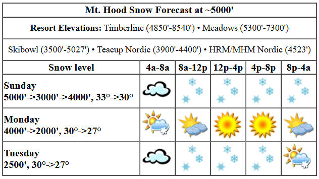
Today’s Mt Hood weather will be increasingly snowy. The snow level starts around 5000′, falls to 3000′ in the afternoon, and rises to 4000′ overnight. Temps will be right around freezing in the morning and will fall to 30F or so in the afternoon and overnight. About 0.3” water equivalent (WE) is forecast today for 2-3” of relatively dense new snow at 5000′. Overnight, another 0.2” WE is forecast for a couple inches more. Wind: variable to 15 this morning, NW 20-25 this afternoon, and NW 20-25 overnight. Snow surface is full-transformed snow working its way to granular, but the new snow will cover it up.
Monday kicks off with light snowfall and quickly turns sunny. High clouds return overnight. The snow level will be 4000′ in the morning, 2500′ in the afternoon, and 2000′ after midnight. Temps start around 30F and fall to 27F in the evening. Just an inch of snow is forecast early in the morning prior to the sun coming out. Wind will be NW 20-25 all day and SW 10-15 after midnight.
High clouds Tuesday morning give way to light snowfall midday. The snow level will be 2500′ most of the day, and the freezing level will drop to 2000′ overnight under partly cloudy sky. Temps will be around 30F in the morning and will fall to 27F in the evening. About 0.2” WE is forecast during the day for a couple inches of new snow. Another inch or so falls in the evening. Wind: SW 10-15 in the morning builds to WSW 35-40 in the afternoon and becomes W 25 after midnight.
High clouds Wednesday morning give way to clear sky with the freezing level around 3000′ and light wind. Thursday looks quite similar with a repeat of the clouds-clearing pattern As of right now, Friday looks sunny. Saturday looks dry. Models had previously been contemplating a Pineapple Express next Sunday, but it’s looking very likely that will stay well north of us. Also likely: increasing snowfall along with cooler temps (mid 20s, probably) starting next Monday with (hopefully) lots of snow in the cards for the week of March 10th. Fingers crossed! Have a great day on the snow!
Liking this forecast?
Was that helpful? I knew it was! Guess what? All of this crucial work – from your personal wind and snow reports to the invaluable TATAS updates – is made possible by my relentless efforts. Maintaining this labor of love isn’t easy. Each daily forecast takes hours. Website hosting, weather model access, and back-end admin work takes time and money. That’s where you come in.
YOUR CONTRIBUTION MAKES A DIFFERENCE
- SUPPORT ACCURATE, HYPER-LOCAL WEATHER FORECASTING
- ENABLE ACCESS FOR ALL, EVEN THOSE WITH LESS MEANS
- SUPPORT A COOL HUMAN WHO WORKS HARD SO YOU CAN PLAY
Take a moment to click one of the buttons below. Donate $19.99 or more (how much does this forecast enhance your life?) and get the email in your inbox. Whether it’s a renewing subscription (auto-renew) or a one-time donation, every contribution makes a real difference. Help me keep this labor of love alive, so we can all continue playing, commuting, and living in the Gorge with peace of mind and the best weather forecasts possible. Thank you!


Hood River, Oregon 97031


GORGE WIND FORECAST

Hi friends! Wind is in the picture despite the picture not being ideal – lots of moving pieces. Sunday and Monday bring westerlies. Not much happens Tuesday and Wednesday. After that – no clear sign of strong-enough wind from either direction, but models can always change! Sunday kicks off with pressures of 29.87/29.79/29.81 for W 0.08 and E 0.02. We’ll see westerlies at 14-17mph or so all day from Stevenson to Mosier. From Lyle to Arlington, the wind builds to 26-29 this afternoon, which is right on the edge of “enough” for paddling and potentially just enough for winging. Remember, those eastern Gorge sensors read high compared to those at the Hatch and Doug’s. River flow over the last 24 hours was 102-149kcfs, river temp is 39.2F, and high temp forecast is 50F with drizzle most of the day all the way out into the desert.
Monday sees a weak low move inland and high pressure build offshore and push inland behind it. This makes the wind a moving target. Early westerlies will be in the 18-21 range from Viento to Doug’s with 20-23 readings from Avery to Arlington. Wind west of Lyle drops to 14-17 at the high pressure builds inland. From Doug’s to Boardman, we should see 27-30mph in the afternoon, again, right on the edge. High temp: 52F with showers on the west side in the afternoon and sunshine out east. Tuesday starts calm, turns light easterly, then turns light westerly. High temp: 51F with rain. Wednesday looks light and variable. That’s it for now. Have a great day on the river !
BARE BONES HOOD RIVER WEATHER FORECAST
Clouds this morning add drizzly from mid-morning on. Temps hold around 50F all day. Light to moderate westerlies. 89% chance of rainbows. Monday will be dry in the morning with a few sprinkles in the afternoon or evening. Temps start in the low 40s and rise to the low 50s. Moderate westerlies. 94% chance of rainbows. Tuesday will be rainy. Temps start in the upper 30s and rise to 50 or so. Light and variable wind. 93% chance of rainbows.
TEMIRA’S AWESOME TRAVEL ADVISORY SERVICE
HYPERLOCAL WEATHER FORECAST FOR THE COLUMBIA GORGE
THE DALLES, HOOD RIVER, WHITE SALMON, TROUT LAKE, STEVENSON, CASCADE LOCKS, PARKDALE, ODELL, HUSUM, BZ, MILL A, WILLARD, GOLDENDALE, RUFUS, ARLINGTON, boardman
Good morning, neighbors! Spring is in the rear view mirror, and winter is back like a booty twerking its way to the front of your attention. If the extended models are correct, winter could really be back, at least above 1000′ or so, for the second week of March. But we don’t really have to worry about that yet.
Glenwood started the day at 32F with a dewpoint of 27F. Good job, Glenwood. We now take a detour from our usual focus on Glenwood to peek at Hood River, where it was 50 degrees to start the day. As of the time of this forecast, Hood River was on track for a new record high-low for the date. 50 degrees is a REALLY warm low temp for early March. On to the TATAS Executive Order Of The Day: Global warming and associated climate change is real, and it’s a priority for us to do something about it. Signed in really hot ink.
today
Today’s weather: cloudy to start then drizzly for all of us. That includes the west side, the east side to the Arlington Triangle, and SW/Sherm. Drizzle finally ends tonight after my bedtime (7:45pm) to the north and finishes up around midnight (the time I wake up to pee for the first time) to the south. Parkdale’s the exception. It could stay drizzly past midnight. Temps max out around 50 today. West wind picks up to 15mph west of Lyle and 20-25mph from Lyle east to Boardman. Know what today is? A great day to fire up some pepper starts.
monday
A few sprinkles are possible west of Mosier on Monday. If you’re east of there, you’ll have clear sky all day. If you’re west of Mosier, celebrate the sprinkles with a rainbow sprinkle donut! With the free air freezing level around 4000′ and west wind present to start the day, frost is, for once, unlikely. Morning temps start in the low 40s in the lowlands. Afternoon highs finish up in the low 50s. West wind will be 20mph in the morning. In the afternoon, it drops to 15mph west of Lyle and climbs to 20-30mph from Lyle to Boardman.
tuesday
Tuesday looks drizzly pretty much all day. Well, the precip model says so. The cloud cover model thinks we’ll clear off in the afternoon. We can’t rule out a little wet snow early in the morning above 2000′, but we can’t rule it in either. Uncertainty is the spice of life, kinda like a box of donuts, which shouldn’t be uncertain: it should only contain glazed cake donuts and apple fritters and rainbow sprinkle donuts. Temps max out in the low 50s along the 84/14 corridor on Tuesday. Wind will be calm, then light easterly, then light westerly.
wednesday onward
Dry weather returns for Wednesday through at least Saturday with high temps near 50. Intermittent high clouds will be part of the picture, but we should have plenty of sun too. Looking way out into the future, things look colder and wetter starting around March 10th. Get as much garden prep done before then as possible (I’m talking to myself). Safe travels. -TATAS
HEY! DON’T STOP READING! Is this community-focused forecast helpful to you? It sure is! It takes me a couple hours a day to write. Please join your friends and neighbors in contributing to keep it going. Venmo: @thegorgeismygym PayPal: [email protected] USPS: Temira / PO Box 841 / Hood River, Oregon 97031 You can test out the forecast subscription for a few days for free by clicking this link: https://subscribepage.io/YhevGc

One response to “Sunday’s Mt Hood weather: snow returns. Light snowfall this week, and perhaps much, much more next week.”
Hi Temira. I paid $25 via Venmo, but my email subscription hasn’t restarted. Can you please check it for me? Thank you. I really appreciate your forecasts.