

MT HOOD WEATHER FORECAST
Hey skiers and snowboarders! After yesterday’s wild Mt Hood weather, we now have a very mellow day on Mt. Hood. Sadly, all that wind yesterday destroyed the fresh powder, and on top of that, the storm bringing all the wind brought less moisture than models predicted. Sounds like the groom up there is packed powder, but off the groom, it’s windslab, sastrugi, and scoured granular areas. With above-freezing temps forecast for the next four days, we’ll see a quick transition to hardpack then, hopefully, corn. Hit the slopes as early as you can, because the snow will get sticky in the afternoon. If nothing else, it’ll be nice to have warm, sunny, light-wind weather for a change!
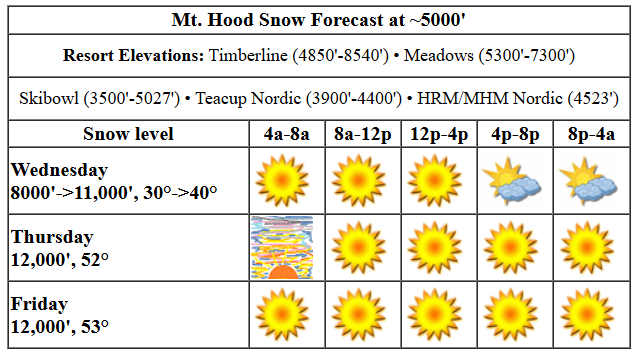
Wednesday started sunny and sub-freezing, but it’ll warm up fast. The free air freezing level rises form 8000′ this morning to 11,000′ this evening with temps at 30F early, 40F this afternoon, and potentially well into the 40s overnight. Wind will be light W in the morning, S 10-20 this afternoon, and WSW 10-15 after midnight.
Thursday will have some high clouds and a pretty sunrise to start with clear, sunny weather for most of the day. It’s likely that radiational cooling will allow the snow to refreeze Wednesday night, so you’re probably looking at hardpack and partially transformed snow. The free air freezing level starts at 11,000′ and rises to 12,000′ with temps maxing out in the low 50s. Bring sunscreen. Wax warm.
Friday looks a lot like Saturday: warm, sunny weather for Mt Hood, with very light wind and temps in the 50s. Snow: partially transformed moving towards granular/corn. As of this morning, another sunny, light wind day is forecast on Saturday with temps maxing out in the mid 40s. Sunday starts sunny, turns clouds, and brings in some snow overnight. The timing of the incoming clouds on Saturday, and the timing of incoming precip on Sunday is still up in the air. Looking out farther into the future, models generally call for snow for a while. Sounds pretty good to me. See you on the snow!
Liking this forecast?
Was that helpful? I knew it was! Guess what? All of this crucial work – from your personal wind and snow reports to the invaluable TATAS updates – is made possible by my relentless efforts. Maintaining this labor of love isn’t easy. Each daily forecast takes hours. Website hosting, weather model access, and back-end admin work takes time and money. That’s where you come in.
YOUR CONTRIBUTION MAKES A DIFFERENCE
- SUPPORT ACCURATE, HYPER-LOCAL WEATHER FORECASTING
- ENABLE ACCESS FOR ALL, EVEN THOSE WITH LESS MEANS
- SUPPORT A COOL HUMAN WHO WORKS HARD SO YOU CAN PLAY
Take a moment to click one of the buttons below. Donate $19.99 or more (how much does this forecast enhance your life?) and get the email in your inbox. Whether it’s a renewing subscription (auto-renew) or a one-time donation, every contribution makes a real difference. Help me keep this labor of love alive, so we can all continue playing, commuting, and living in the Gorge with peace of mind and the best weather forecasts possible. Thank you!


Hood River, Oregon 97031


GORGE WIND FORECAST

Hi friends! It was so good to see all of you yesterday! We’ll have easterlies the next three days, not much on Saturday, and some limited potential for westerlies Sunday and Monday. Keep calling NWS and asking them for wind on those days, okay? Wednesday kicks off very different than Tuesday: we have easterlies at 38mph at Iwash and 25mph at Stevenson to start. Stevenson picks up to 25-30mph, and Iwash (Rooster) holds until early afternoon. The wind then drops to 25mph at Stevenson and 30-35mph at Iwash. River flow over the last 24 hours was 79-158kcfs, river temp is 38.12F, and high temp forecast is 54F with sunshine in the morning and filtered sun later.
Thursday starts with easterlies at 25mph at Iwash and 15mph at Stevenson. Stevenson holds all day. Iwash drops to 15mph by late morning and 10mph I the afternoon. High temp: 59F with high clouds early and sun later. Friday brings another round of east wind: 25mph at Iwash to start and 20mph at Stevenson. The wind peaks midday with 25mph at Iwash and 20-25mph at Stevenson. After that: 20mph at Iwash and 15-20mph at Stevenson. High temp: 59F and sunny. Not much is in the cards for Saturday, and there’s quite a bit of uncertainty as far as wind goes for Sunday and Monday. You know what to vote for: wind!
BARE BONES HOOD RIVER WEATHER FORECAST
Clear sky this morning with a few high clouds later. Temps start in the low 30s and rise to the mid 50s. Light easterlies. No rainbows. Thursday will be partly high overcast then clear. Temps start in the mid 30s and rise to the upper 50s. Light easterlies. No rainbows. Friday will be partly Nothing then clear. Temps start in the upper 30s and rise to NEARLY 60!!!! Light easterlies. No rainbows.
TEMIRA’S AWESOME TRAVEL ADVISORY SERVICE
HYPERLOCAL WEATHER FORECAST FOR THE COLUMBIA GORGE
THE DALLES, HOOD RIVER, WHITE SALMON, TROUT LAKE, STEVENSON, CASCADE LOCKS, PARKDALE, ODELL, HUSUM, BZ, MILL A, WILLARD, GOLDENDALE, RUFUS, ARLINGTON, boardman

Good morning, neighbors! So much for stormy weather. How does 3-4 days of sunny, warm weather sound? Sounds pretty good to me. Next chance for rain is Saturday night, and after that, ensembles hint at a return to cooler, wetter weather for a while. So, enjoy this little Spring Break!
GLENWOOD & TATAS EOOTD
Wednesday will be sunny. Wait. Let’s check in with Glenwood! 25 degrees there this morning with a dewpoint of 20 degrees. TATAS Executive Order Of The Day: people can work remotely as long as they are able to get the job done. Signed with a virtual pen. Because virtual workspaces require virtual pens.
WEDNESDAY THROUGH FRIDAY
Back to Wednesday: sunny, adding some high clouds. Temps max out in the mid 50s. At Iwash, there will be 40mph wind in the morning and 30-35mph wind in the afternoon. So, no hanging at the naked beach today. Your best bet for that is Saturday. Stevenson: 25mph all day. This is pretty much the forecast for the next three or four days. Just subtract 10mph from the east wind and add 5 degrees to the high temps. While frost is likely tomorrow morning, the chances drop on Friday morning as the entire air mass slowly responds in response to 50 degree weather at 5000′.
THE WEEKEND AND BEYOND…
Change arrives on Saturday with a noon protest at the Salmon Fountain in Hood River. Wait, demonstrations are important so people don’t feel alone, but they don’t usually change things unless they happen on a massive scale. But the weather will start to change on Saturday, perhaps. It’ll still be sunny, and it’ll still be above 50 degrees. Okay, okay, the real change happens sometime Sunday – currently scheduled for Sunday afternoon – when a system drags in some lowland rain and mountain snow. Models then disagree on what happens next. Another brief dry spell is present in the Euro, and the GFS prefers more rain. So, if you have dry-weather tasks to complete (like putting manure in your compost pile or garden), do it this week. Guess I’d better go call Poop Peter and Poop Mary… Happy gardening. Safe travels. -TATAS
HEY! DON’T STOP READING! Is this community-focused forecast helpful to you? It sure is! It takes me a couple hours a day to write. Please join your friends and neighbors in contributing to keep it going. Venmo: @thegorgeismygym PayPal: [email protected] USPS: Temira / PO Box 841 / Hood River, Oregon 97031 You can test out the forecast subscription for a few days for free by clicking this link: https://subscribepage.io/YhevGc
