

MT HOOD WEATHER FORECAST
Hey skiers and snowboarders! Mt. Hood weather is going to be a bit of a wild ride for the next couple of days. The probability of lifts running Tuesday is quite low, except perhaps at Skibowl, which is lower and somewhat more protected. After Tuesday’s blizzard, we’ll have a few days of unseasonable warm weather with quite a bit of sunshine. Looking at next weekend, models hint at cooler, wetter weather, but the details are far from clear, and a forecast isn’t yet possible.
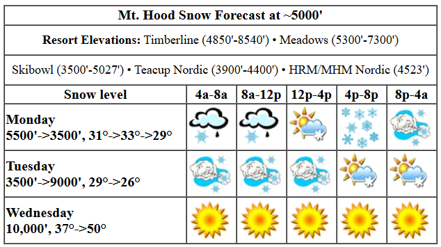
Let’s look at Monday: a system sweeps in from the south. Models have temps at 5000′ rather borderline this morning and plenty cold for snow, lots of it, this evening. That said, at 7;30am, it was snowing at 5000′. The snow level today, daytime, bounces around between 5000′ and 6000′ before falling to 3500′ tonight. Temps rise to 33F or so mid-morning before falling to 29-30F overnight. About 0.6” water equivalent (WE) is forecast during the day as mixed precip or very wet snow. Call it 2-4” new. Overnight, as the wind ramps up and orographic assistance kicks in, we’re expecting 1.1” WE for 11-15” new snow depending on how the wind helps us out. Wind today will be S 10-20 this morning, SW 30-55 this afternoon, SW 40-65 this evening, and WSW 70-80 after midnight. That’s strong enough to turn all the new snow into windslab and sastrugi rather than powder.
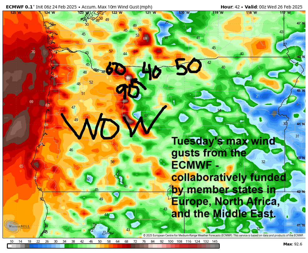
Tuesday’s weather will be a full-on blizzard with zero viz and trees falling down. Yeah, it’s going to be THAT windy. The snow level starts around 3500′ and falls to 2500′ in the afternoon before rising to 9000′ under clear sky overnight. Temps start around 29-30F, fall to 26F in the afternoon, and rise above freezing overnight. During the day, 1.3” WE (or more, thanks to orographics!) is forecast. Call it 13-16” new snow. Just a trace is forecast after 4pm. Unfortunately, the wind will be blasting all the way through 4pm. Keep an eye on Skibowl’s night ops for the best chance at pow riding. Wind: WSW 70-80 in the morning (no lifts at Meadows or T-Line), W 60 in the afternoon (ditto – no lifts), W 45 after 1pm (lifts become possible), and SE 10-15 after midnight. That much wind combined with lots of available moisture could drive snowfall totals even higher.
Get it as early as you can on Wednesday – temps will be warming rapidly. The day starts with the freezing level between 9000′ and 3000′, depending on location. By afternoon, the freezing level will be 10,000′ with temps pushing 50 degrees! Wind: SE 10-15 in the morning, SWW 10-15 in the afternoon, and SW 10-20 after midnight. Thursday and Friday both look dry and warm with temps pushing into the mid/upper 40s. Saturday will probably be sunny and dry and warm as well. Models hint at a return to snow (probably) on Sunday. That’s it for now. Have a great day on the snow!
Liking this forecast?
Was that helpful? I knew it was! Guess what? All of this crucial work – from your personal wind and snow reports to the invaluable TATAS updates – is made possible by my relentless efforts. Maintaining this labor of love isn’t easy. Each daily forecast takes hours. Website hosting, weather model access, and back-end admin work takes time and money. That’s where you come in.
YOUR CONTRIBUTION MAKES A DIFFERENCE
- SUPPORT ACCURATE, HYPER-LOCAL WEATHER FORECASTING
- ENABLE ACCESS FOR ALL, EVEN THOSE WITH LESS MEANS
- SUPPORT A COOL HUMAN WHO WORKS HARD SO YOU CAN PLAY
Take a moment to click one of the buttons below. Donate $19.99 or more (how much does this forecast enhance your life?) and get the email in your inbox. Whether it’s a renewing subscription (auto-renew) or a one-time donation, every contribution makes a real difference. Help me keep this labor of love alive, so we can all continue playing, commuting, and living in the Gorge with peace of mind and the best weather forecasts possible. Thank you!


Hood River, Oregon 97031


GORGE WIND FORECAST

Hi friends! Hopefully you’re in windsport shape with your game in top shape, because there’s a darn good chance you’ll be wanting all those skills on Tuesday. That’s followed by more reasonable easterlies on Wednesday. Beyond that: probably not much, but we can’t rule out moderate westerlies on Thursday along with 55-60 degree weather. Monday sees easterlies build as a strong low pressure system moves north along the coast. Iwash (Rooster) builds to 40mph by early afternoon, and Stevenson builds to 35mph. Sometime after 4pm, probably later than yesterday (stoked for those of you who got those late laps yesterday), the wind turns westerly at 15mph or so. River flow over the last 24 hours was 112-162kcfs, river temp is 37.58F, and high temp forecast is 50F with pouring rain starting from 8am or so on.
That low I mentioned moves inland into northern WA on Tuesday. We’ll be south of it in the zone of strongest wind. Models aren’t consistent in telling us exactly how windy it will be on the river, but “nuking” is definitely a possibility, especially east of The Dalles. Why? Because “nuking” will definitely be happening aloft, and that’s a great sign for Rufus. At daybreak, we should have 30+ from Iwash to Mosier, lighter wind between Lyle and Avery, and 25-30 out east. 30-40 sees reasonable mid-morning for the Hatch and also for Avery to Boardman with 25-30+ from Hood River to Doug’s.
After 1pm, the wind starts to fade: 17-20ish west of The Dalles and 26-30+ to the east. It keeps dropping after 4pm. The west side finishes at 10mph or so as high pressure pushes inland. You’ll need to head east of Rufus for lingering 25-28 for the Executive session. High temp: 50F with pouring rain west of The Dalles through 11am or so, pouring rain in Stevenson through 1pm or so, and dry weather out east after 10am with mostly clear sky.
Easterlies return for Wednesday with sunshine and 50+ degree temps. Stevenson maxes out at 30-35 midday before fading to 25mph in the evening. Iwash starts at 40mph and fades just a bit to 35mph. Light westerlies are possible but far from certain on Thursday. That’s enough for today. Get ready for tomorrow! Also, don’t forget to plan for dinner from Amayah’s tomorrow night!
BARE BONES HOOD RIVER WEATHER FORECAST
Mostly clear sky this morning quickly turns cloudy then wet then very wet. Temps star tint he mid/upper 30s and rise to 50. Calm wind most of the day. Westerlies build overnight. 11% chance of rainbows. Tuesday will be very wet through midday then showery, then dry in the evening. Temps start in the low 40s and rise to 50. Nuking westerlies. 99% chance of rainbows. Wednesday will be Nothing to start then sunny then partly high overcast. Temps start right at freezing and rise to the mid 50s. Light easterlies. No rainbows.
TEMIRA’S AWESOME TRAVEL ADVISORY SERVICE
HYPERLOCAL WEATHER FORECAST FOR THE COLUMBIA GORGE
THE DALLES, HOOD RIVER, WHITE SALMON, TROUT LAKE, STEVENSON, CASCADE LOCKS, PARKDALE, ODELL, HUSUM, BZ, MILL A, WILLARD, GOLDENDALE, RUFUS, ARLINGTON, boardman
Good morning, neighbors! Here we go again… lots of moisture in the forecast today. And with the sky clearing more than expecting last night and temps falling lower than expected, a few of you are likely to pick up a little freezing rain this morning. Starting tonight, we’ll have very strong west wind, enough to potentially knock some trees down on 84/14. That’ll combine nicely will all the rocks falling on SR-14 and 142. All you have to do is make it through a VERY windy Tuesday, and you’ll be rewarded with warm, calm weather Wednesday through Saturday.
GLENWOOD AND THE TATAS EOOTD
But first, Glenwood! 31 degrees this morning with the potentially for a little freezing rain before a switch to a downpour. TATAS Executive Order Of The Day: Capital gains shall be taxed at no less than an individual’s highest marginal tax rate. Signed with gold sparkle pen.
TODAY
Today brings a very wet system from the south and follows it up, one-two punch, with another one from the west. Pouring rain falls west of Hood River this morning through about 7pm. It lessens, and then is replaced by a torrential downpour between us and the city tonight. SW/Sherm also get a drenching this afternoon and evening, as do areas from The Dalles eastward to Idaho from about 1pm on. High temps max out around 50F along the river, and the snow level will be 5500′ daytime and 3500′ overnight. One small thing: a few areas – Glenwood and Trout Lake – are just below freezing this morning and will pick up a little ice before temps warm.
TUESDAY
Things get really exciting late tonight as a low sweeps up the coast and starts to move inland in WA. We’ll be south of it, and we’re going to get stung. First, we get torrential rain from 1am or so on west of The Dalles with moderate rain eventually extending all the way to Arlington. Rain backs off after 1pm. Westerlies pick up, way up, early Tuesday morning west of Hood River and east of The Dalles. It could be windy enough to knock down a tree or two, so be very, very careful on 84 and 14 and Dee Highway and wherever else trees are growing – with the ground saturated, they might just give up and fall over more easily than usual. Just how windy will it be? Average speeds of 30-40mph seem likely, and gusts above 50mph are also likely. Strong wind will not just be on the river. It’ll be found in the hills, valleys, and plateaus tomorrow as this system sweeps inland. NWS Pendleton has issued a rare Gorge wind advisory for this. Up on Bennett Pass and nearby areas of 35/26, it’ll be a complete whiteout with blasting wind and dumping snow. Skip it. High temp along the commuter corridor: 50F.
WEDNESDAY AND BEYOND – WARM!!!
High pressure builds inland on Wednesday shuts down all the fun/chaos. After a partial Nothing start with clear sky away from the river, we’ll have a few high clouds and 55 degrees in the lowlands. Up in the mountains, temps are forecast to rise as high as 50 degrees too, so it’ll be a darn nice day everywhere. Wind: easterly at 40mph near Iwash and 30mph near Stevenson. Thursday, Friday, and potentially Saturday all look warm and dry. Precip returns (probably) Sunday. That’s it for today. Safe travels. -TATAS
HEY! DON’T STOP READING! Is this community-focused forecast helpful to you? It sure is! It takes me a couple hours a day to write. Please join your friends and neighbors in contributing to keep it going. Venmo: @thegorgeismygym PayPal: twomirrors@gmail.com USPS: Temira / PO Box 841 / Hood River, Oregon 97031 You can test out the forecast subscription for a few days for free by clicking this link: https://subscribepage.io/YhevGc
