

MT HOOD WEATHER FORECAST
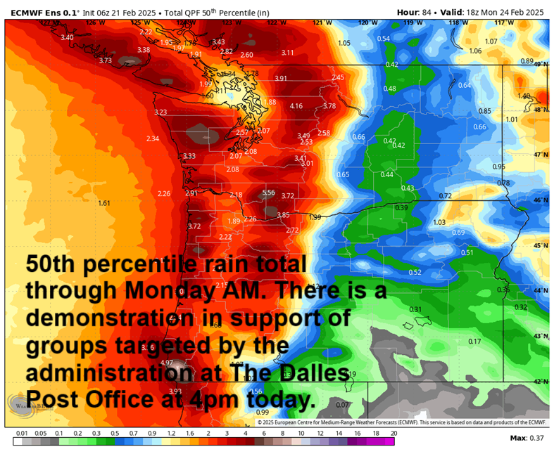
Hey skiers and snowboarders! If you like rain, you’re gonna love Sunday. If not, make your plans for a different day this week. We’ll see clouds Friday, rain starting (probably) Saturday afternoon, torrential rain Sunday, a break Monday morning, and rain switching to snow Monday night with decent accumulation possibly by Tuesday. After that, we’ll have at least a few days of warm, dry weather. Models generally (with lots of differences) keep temps too warm for snow again until next weekend, but there’s a lot that could change between now and then.
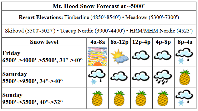
Let’s look at Friday’s weather on Mt. Hood. Partly cloudy sky early quickly clouds over and leaves you with flat light. Overnight, some mixed precip arrives, but probably not until the end of the night ski session. Today’s snow level starts around 6500′, briefly falls to 4000′ with the arrival of precip, and quickly bumps back up to 5500′. Temps at 5000′ start at 31F and rise to the upper 30s today before dropping to the mid 30s overnight. Just a trace to 0.1” mixed precip is forecast tonight. Wind: SSW 10 this morning, SW 15-25 this afternoon, and SW 25-40 overnight.
A little drizzle or mixed precip Saturday morning quickly ends and leaves the mountain dry and cloudy until 4pm or so. After that: rain. The snow level will be 5500′ early and will slowly rise to 8500′ by the afternoon and 9500′ (!!) overnight. Hello, Pineapple Express. Temps start in the mid 30s and rise to 40F or so. Just a trace of mixed precip is forecast early in the morning. Overnight, about 0.7” rain is in the cards. Wind will be SW 25-40 during the day and will rise to WSW 40-50 overnight. That’s enough wind to take out higher lifts like Cascade and Vista, but not enough, and not from the right direction, to shut down the standard offerings at any of the resorts.
Sunday: if you don’t have a hefty bag, don’t try it. It’s going to be WET. The snow level starts at 9500′ and basically holds all day. Overnight, it falls to 4000′, but not until the precip is basically done. Temps: upper 30s all day falling to 31-33F overnight. We might see a trace of snow at the end of all the rain. How much rain? Welllllll…. 1.7” during the day and 1.5” overnight, but I wouldn’t be surprised at all if we exceed that given the combo of impressive available moisture and solid WSW wind. Wind: WSW 40-50 in the morning, WSW 50-60 in the afternoon, and W 30 overnight. That period of 50-60mph wind from the WSW might be just enough to impact lifts. Maybe. That direction isn’t always problematic, even with strong wind. That said, a small change in direction could wreak havoc.
Monday looks dry and cloudy in the morning with rain from midday on. Rain switches to snow overnight. Models are hinting at half a foot of new as the snow level drops to 2500′. Fingers crossed. Tuesday starts with light snowfall and turns dry by afternoon. Starting Wednesday, the mountain looks warm and sunny for at least a few days. Let’s leave it there for now. You’ve got your weekend plans made, right? See you on the snow!
Liking this forecast?
Was that helpful? I knew it was! Guess what? All of this crucial work – from your personal wind and snow reports to the invaluable TATAS updates – is made possible by my relentless efforts. Maintaining this labor of love isn’t easy. Each daily forecast takes hours. Website hosting, weather model access, and back-end admin work takes time and money. That’s where you come in.
YOUR CONTRIBUTION MAKES A DIFFERENCE
- SUPPORT ACCURATE, HYPER-LOCAL WEATHER FORECASTING
- ENABLE ACCESS FOR ALL, EVEN THOSE WITH LESS MEANS
- SUPPORT A COOL HUMAN WHO WORKS HARD SO YOU CAN PLAY
Take a moment to click one of the buttons below. Donate $19.99 or more (how much does this forecast enhance your life?) and get the email in your inbox. Whether it’s a renewing subscription (auto-renew) or a one-time donation, every contribution makes a real difference. Help me keep this labor of love alive, so we can all continue playing, commuting, and living in the Gorge with peace of mind and the best weather forecasts possible. Thank you!


Hood River, Oregon 97031


GORGE WIND FORECAST

Hi friends! Glad to see some folks got out yesterday in the light westerlies. You might get another chance on Sunday and again on Tuesday, but models are far from certain. Know what you will get the next few days: wet! Friday starts with east wind at 30mph at Iwash (Rooster), 15mph at Stevenson, and 22 mph at Viento. The wind lasts a few hours then fades. Iwash ends with 15-20mph, and Stevenson finishes at 10-15mph. Overnight, the wind turns westerly between Iwash and Stevenson. River flow over the last 24 hours was 79-151kcfs, river temp is 37.76F, and high temp forecast is 46F with clouds.
Saturday brings southerly wind over the region, and that won’t do much for the central and eastern Gorge. You’ll find westerlies at Iwash and Stevenson at 15mph or so to start the day. Stevenson may build to 20-25mph in the afternoon just before a torrential downpour arrives and sets in for the night. High temp: 51F, cloudy, and drizzly. Sunday swings a front through and turns the wind onshore. Some models make it windy, and some do not. About 20% of the euro ensemble has a strong day out east. At this point, all we can do is watch it. Also on tap for Sunday: super heavy rain. Monday brings east wind. Tuesday brings another shot at westerlies, but again, models have way too much variety to make a solid call. It is worth noting that high temps will be pushing into the 50s and staying there for a while, so wind or no wind, there will be fun stuff to do outside! Hope to see you on the river soon!
BARE BONES HOOD RIVER WEATHER FORECAST
Nothing this morning turns cloudy later. Temps start in the mid 30s and rise to the mid 40s. Light easterlies. No rainbows. Saturday starts with drizzle. Rain becomes very heavy in the evening and sticks around overnight. Temps start in the upper 30s and rise to the low 50s. Calm wind. No rainbows. Sunday will be rainy. Temps start in the mid 40s and rise to the mid 50s. Light to moderate westerlies. 1-2% chance of rainbows.
TEMIRA’S AWESOME TRAVEL ADVISORY SERVICE
HYPERLOCAL WEATHER FORECAST FOR THE COLUMBIA GORGE
But first, let’s check in with our friends in Glenwood. It’s was 29 degrees there at 6:51am with a dewpoint of 22F. Executive Order Of The Day: everyone is subject to the law.
today (it’s friday, yo)
On to today’s weather… OMG, the sunrise this morning is spectacular. Was spectacular. Clouds thicken today like a bechamel sauce getting ready for cheese, pasta, and baking into the best mac n cheese ever. Unfortunately, that recipe is behind the NYT paywall. Which is part of the reason people resort to extremist and inflammatory news sources – they are generally free! Anyway, we’ll see a little rain late tonight. Wind today will fall from E 30mph to E 15mph at Iwash and switch to W 15mph overnight. East of Viento, the wind will be light all day. Moving on…
saturday
INTERESTING weather arrives after a mostly dry Saturday day. Pineapple Express pulls in, takes aim at the latitudes between, oh, Pahto and Mt. Hood, and drenches us. If you’re going to the metro area for a show Saturday night, it better be a damned goods one, because the drive home will be through torrential rain (after 7pm or so). Rain extends all the way to Lyle and into the WA hills. SW/Sherm: not much at all. Temps max out at 51F on Saturday, beginning a long streak of 50+ degree weather.
sunday
Pouring rain is in the cards most of the day on Sunday for areas west of Mosier. West of Hood River, the rain will be torrential from about 1am on through 7pm with a brief decrease to super-heavy rain between 10am and 1pm. Pretty much all of us not in SW/Sherm will get a soaking on Sunday. The only exception is a small zone between perhaps the Arlington Triangle and Boardman, where partly cloudy sky is possible. Maybe. We’ll see how that plays out as we get closer. High temp: 56F – warm! Wind: westerlies at 15-25mph between Iwash rock and Rufus.
monday and beyond
Monday morning looks dry, but rain returns in the afternoon and sticks around through Tuesday morning. After that, we should have a few dry, warm, potentially sunny days. High temps might even make it into the 60s! Won’t that be nice? Safe travels. -TATAS
HEY! DON’T STOP READING! Is this community-focused forecast helpful to you? It sure is! It takes me a couple hours a day to write. Please join your friends and neighbors in contributing to keep it going. Venmo: @thegorgeismygym PayPal: twomirrors@gmail.com USPS: Temira / PO Box 841 / Hood River, Oregon 97031 You can test out the forecast subscription for a few days for free by clicking this link: https://subscribepage.io/YhevGc
