

MT HOOD WEATHER FORECAST
Hey skiers and snowboarders! Mt Hood weather today: we’re in for another big day of snow accumulation on Mt. Hood. That’s followed by (mostly) dry weather Thursday and Friday. Models now call for rain to arrive Friday night into Saturday with pouring rain starting Saturday afternoon and continuing into Monday morning. Beyond that: warm and mostly dry for the extended forecast. Get that powder today!
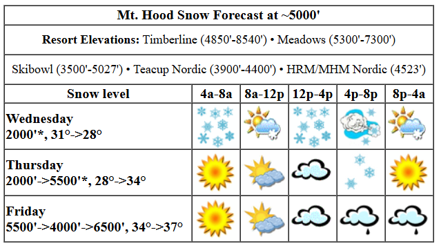
Before we dive in, I want to mention that there there was a period of rain late last night (Tuesday night), but it’s been snowing since about midnight. You may feel that in the snowpack. Or maybe not, because we’re expecting a lot of snow today. The snow level will be around 4000′ all day, and it’ll fall to 2000′ or less overnight. Temps at 5000′ start in the low 30s and fall to the upper 20s. Models have about 0.9” water equivalent during the day for about 9” of new snow. Overnight: just a trace. There may be a short (60-90 minutes) break in the snowfall in the 9-11am period. Wind today will be SSW 15-30 early, W 35-40mph in the afternoon, and WNW 35mph overnight. That’s probably not quite enough to shut down lifts, so proceed with your storm skiing adventures!
Thursday starts sunny and quickly turns cloudy. A trace of snow is forecast in the afternoon before the sky clears again overnight. The snow level will be 2000′ in the morning, 4000′ in the afternoon, and will rise to 5500′ overnight. Temps start around 28F, rise to 34F in the afternoon, and climb to the mid/upper 30s overnight. Wind: WNW 30-35 early slowly fades to NW 10-15 in the afternoon and turns light westerly overnight. Friday looks sunny early, cloudy in the afternoon, with (mostly) rain overnight. The snow level starts around 5500′, briefly drops to 4000′ with the arrival or precip, and quickly rises to 6500′ with rain all night. Temps start in the mid 30s and rise a couple of degrees into the evening. Just 0.1” to 0.2” rain is forecast, which is an appetizer to the main Pineapple course this weekend. Friday wind: Light westerly early rising to SW 10-20 in the afternoon and building to WSW 30 overnight.
Saturday will be cloudy to start with very light drizzle. Daytime riding, at this point, actually looks okay. The downpour starts late afternoon. The snow level will be 6500′ in the morning, and it will rise to 9000′ with the arrival of the pineapple express. Temps will be pushing 40F all day. A trace to 0.1” rain is forecast during the day. A couple inches of rain are forecast overnight. Wind will be WSW 20-25 in the morning, SSW 25-45 in the afternoon, WNW 45-50 in the evening (affecting lifts, if they are still open), and SW 15-25 overnight. Heavy rain continues all day and all night Sunday. Light rain persists into Monday and is followed by a wetter system Tuesday. Beyond that, most ensemble members have us warm and dry for a while with (hopefully) plenty of sun. Get up there for freshies today, and dig out your hefty bag for the weekend. See you on the snow!
Liking this forecast?
Was that helpful? I knew it was! Guess what? All of this crucial work – from your personal wind and snow reports to the invaluable TATAS updates – is made possible by my relentless efforts. Maintaining this labor of love isn’t easy. Each daily forecast takes hours. Website hosting, weather model access, and back-end admin work takes time and money. That’s where you come in.
YOUR CONTRIBUTION MAKES A DIFFERENCE
- SUPPORT ACCURATE, HYPER-LOCAL WEATHER FORECASTING
- ENABLE ACCESS FOR ALL, EVEN THOSE WITH LESS MEANS
- SUPPORT A COOL HUMAN WHO WORKS HARD SO YOU CAN PLAY
Take a moment to click one of the buttons below. Donate $19.99 or more (how much does this forecast enhance your life?) and get the email in your inbox. Whether it’s a renewing subscription (auto-renew) or a one-time donation, every contribution makes a real difference. Help me keep this labor of love alive, so we can all continue playing, commuting, and living in the Gorge with peace of mind and the best weather forecasts possible. Thank you!


Hood River, Oregon 97031


GORGE WIND FORECAST

Hi friends! It’s Wednesday, and models are giving us a big “maybe” for wind this afternoon. Not much happens Thursday and Friday, and the weekend looks very, very wet and not so windy. Wednesday kicks off with 35mph easterlies at Iwash (Rooster) Rock and 25mph easterlies at Stevenson. The wind goes dead calm late morning and switches to westerly. Given high pressure offshore and decent wind speeds aloft, westerlies seem likely, although the strongest wind may be after dark. Starting mid-afternoon, we should see gusty 19-23 from Stevenson to The Dalles with 14-17 (and building) east of The Dalles. Models think much stronger wind is possible at Rufus early evening, but it’ll be a race between sunset and the wind arriving. River flow over the last 24 hours was 66-135kcfs, river temp is 38.12F, and high temp forecast is 45F with rain most of the day other than mid-morning.
Thursday starts with lingering west wind. Mid-morning wind will be 14-17 from Stevenson to Swell with 18-23 from Lyle to Arlington. The wind holds for a few hours on the west side and then drops to 10mph or less in the afternoon. Out east, the fade also happens: areas east of Celilo finish the day at 12-15mph, while all areas to the west drop below 10mph. High temp: 47F with clouds in the west and mostly clear sky out east. Friday brings back the easterlies. At daybreak, we’ll have 25-30mph at Iwash and 25mph at Stevenson. Get on it. The fade begins mid-morning. Stevenson finishes the day with 15-20mph, and Stevenson ends the day at 15mph. High temp: 47F with cloudy sky. Not much is in the cards for the weekend other than a lot of rain!
BARE BONES HOOD RIVER WEATHER FORECAST
Rain this morning followed by a short break mid-morning is followed by rain from early afternoon on with showers overnight. Temps start in the mid 30s and rise to the mid 40s. Easterlies early. Calm wind midday. Moderate westerlies later. 99% chance of rainbows. Thursday will be cloudy most of the day with light drizzle mid-afternoon. Temps start in the upper 30s and rise to the upper 40s. Light westerlies. 11% chance of rainbows. Friday will be dry and cloudy until late afternoon. Then it will be wet for several hours. Temps start in the low-mid 30s and rise to the upper 40s. Light easterlies. No rainbows.
TEMIRA’S AWESOME TRAVEL ADVISORY SERVICE
HYPERLOCAL WEATHER FORECAST FOR THE COLUMBIA GORGE
THE DALLES, HOOD RIVER, WHITE SALMON, TROUT LAKE, STEVENSON, CASCADE LOCKS, PARKDALE, ODELL, HUSUM, BZ, MILL A, WILLARD, GOLDENDALE, RUFUS, ARLINGTON, boardman
Good morning, neighbors! It’s just a wonderful weather morning in the Gorge – pockets of wet snow at 1000′ and above, a few areas of freezing rain, and clouds pressing down upon us. After today’s rain comes a couple of dry days, or mostly dry, anyway. That’s followed by a Pineapple Express for the weekend, when folks west of the Cascade Crest will get drenched, and folks to the east will be, for much of the time, wondering what the fuss is about. Extended runs of the ensembles dry us out and warm us up and give us a taste of spring starting in the middle of next week.
glenwood and the tatas eootd
But first… Glenwood. It’s 32 degrees there this morning, and given that it’s snowing in Trout Lake, it’s probably snowing there too. Good job maintaining a grip on winter, Glenwood! Now for the TATAS Executive Order Of The Day: with my green glitter pen, I return separation of church and state. Religious materials can no longer be taught in schools (except in comparative religion classes) or pushed upon people in government workplaces. Want to have an after-school club that celebrates Jesus or Satan or Buddha or Odin or Bacchus or creates space to practice spells and seances and divining? Go ahead! But just because 67% of folks in the US identify as with some sect of Christianity doesn’t mean that everyone can be required to study the bible, pray, or do other religious activities. You’re welcome.
today (wednesday)
On to the weather! It’s wet! Wet like no-knead bread dough with little gluten (yum) molecules swimming around to connect with each other and make flour delicious again. Rain continues pretty much all day west of The Dalles. To the east, it wraps up after noon. Showers continue, on and off, west of The Dalles into the evening. Wind aloft turns westerly at 35-40mph this afternoon, and that should scour out the lingering cold air and warm all the lingering sub-freezing spots. Down on the river, easterlies this morning turn westerly this afternoon with 20-25mph west of The Dalles and 15-20mph east of The Dalles. In the evening, the wind picks up to 20-30mph east of The Dalles.
thursday
Thursday starts cloudy in the west and mostly clear out east. Light west wind sticks around all day, all through the Gorge. Models hint at a little drizzle between Cascade Locks and The Dalles in the afternoon, but many of us will stay dry. Overnight: dry with Nothing developing.
friday
With clear sky aloft and light wind, we’re going to see icy roads on Friday morning above the Nothing. Glenwood should give us a good showing by dropping well below freezing. For the rest of the day, we’ll have increasing clouds above an incoming weather system. Wind will be E 30mph in the morning at Iwash and 15mph in the afternoon. Drizzle moves in late afternoon and extends to The Dalles. There is a demonstration against executive overreach at the post office in The Dalles on Friday. Not sure what time.
Saturday through monday
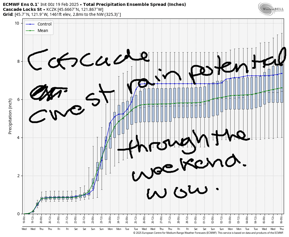
Showers on the west side Saturday morning give way to a torrential downpour in the afternoon and into the night. And if that’s not wet enough for you, something well beyond “torrential” rams the western Gorge Sunday midday like a fire hose turned on rowdy protesters. Let’s hope that doesn’t happen around here! Protect the right to demonstrate! If you can avoid 84/14 west of Mosier Saturday afternoon through early Monday, do so. Unless you’re headed down there to do the Downpour Jog for shits and giggles. Then drive slowly. How much rain are we talking about? Well, along the Cascade Crest, models give us 3-6” total through the weekend thanks to this moderate to strong atmospheric river.
tuesday and beyond
On-and-off rain is forecast through Tuesday. Next up: warm, dry, sunny weather for a few days with temps approaching… wait for it… 60F!!!!! Yes, 60! Please, please let us reach 60F! My pants don’t fit so great, but my shorts do, and it’ll be nice to breathe easy. Safe travels. -TATAS
HEY! DON’T STOP READING! Is this community-focused forecast helpful to you? It sure is! It takes me a couple hours a day to write. Please join your friends and neighbors in contributing to keep it going. Venmo: @thegorgeismygym PayPal: [email protected] USPS: Temira / PO Box 841 / Hood River, Oregon 97031 You can test out the forecast subscription for a few days for free by clicking this link: https://subscribepage.io/YhevGc
