

MT HOOD WEATHER FORECAST
Hey skiers and snowboarders! Orographics gave a huge nudge to the snow totals last night, and the mountain beat expectations with a foot of new snow total. Get it! A windy day today is followed by a less stormy day tomorrow. Sunday into Monday, we’re looking at dumping snow with a couple feet or more falling by Monday night. Get on it – by the following weekend, temps will be much warmer on the mountain. Snow conditions today: dense fresh snow atop dry powder with soft packed powder groom.
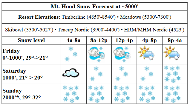
Friday’s weather on Mt. Hood kicks off with snow and wind. By afternoon, we should have some sunbreaks mixed with flurries. The snow level will be 0′ in the morning, 1000′ in the afternoon, and 0′ after midnight near Mt. Hood. Temps will be in the upper 20s this morning, low 20s this afternoon, and ditto overnight. About 0.1” to 0.4” water equivalent (WE) is forecast today for 1-4” of snow. Why the big range? Because we’re counting on orographics to have the totals beat the forecast. Overnight: a trace to an inch as the wind drops and reality sets in. Wind today: NW 30 through the afternoon, W 20 overnight, and WNW 15-20 after midnight. In yesterday’s forecast, I talked about the potential for lift impacts; today’s models have knocked 5-10kts off the wind speed, which leaves us with most of the “normal” lifts running. There could be periods where some lifts (Star at Meadows, for example) get taken out by wind.
On to Saturday: It’ll be cloudy all day. Dry weather in the morning gives way to light snowfall in the afternoon and increasing snowfall overnight. Temps will be warming, but it looks like we should stick with snow, albeit wet snow, for this system. While the snow level will be around 4500′ near the metro area, it’ll be around 1000′ near Mt. Hood. Temps will be in the low 20s in the morning and low 30s in the afternoon. About 0.1” WE is forecast during the day for an inch of new. Overnight, we’re expecting 0.2” WE for a couple inches of increasingly dense snow. Wind: WNW 15-20 in the morning, SW 15-25 in the afternoon, and SW 25-40 overnight.
Heavy, dense snow is forecast all day Sunday. The effective snow level (based on 850mb temps) is forecast to be around 4500′, but it will actually be lower thanks to evaporative cooling and intense snowfall rates, perhaps 2000′. Temps will hover right around freezing. About 1.2” WE is forecast during the day for 8-11” dense new snow. Another 1.0” WE is in the cards overnight for another 7-9” dense new snow. Wind: SW 20-30mph all day turning to WSW 20-25 overnight. Another half a foot of snow is forecast on Monday with moderate west wind. Snow returns Tuesday night into Wednesday and is followed by warming weather and potentially some rain next Friday. But that’s a long ways out to be making predictions. That said, models are pretty much all in on warming towards the end of the week. In the meantime, we’re expecting a ton of fresh snow. Make some of it yours!
Liking this forecast?
Was that helpful? I knew it was! Guess what? All of this crucial work – from your personal wind and snow reports to the invaluable TATAS updates – is made possible by my relentless efforts. Maintaining this labor of love isn’t easy. Each daily forecast takes hours. Website hosting, weather model access, and back-end admin work takes time and money. That’s where you come in.
YOUR CONTRIBUTION MAKES A DIFFERENCE
- SUPPORT ACCURATE, HYPER-LOCAL WEATHER FORECASTING
- ENABLE ACCESS FOR ALL, EVEN THOSE WITH LESS MEANS
- SUPPORT A COOL HUMAN WHO WORKS HARD SO YOU CAN PLAY
Take a moment to click one of the buttons below. Donate $19.99 or more (how much does this forecast enhance your life?) and get the email in your inbox. Whether it’s a renewing subscription (auto-renew) or a one-time donation, every contribution makes a real difference. Help me keep this labor of love alive, so we can all continue playing, commuting, and living in the Gorge with peace of mind and the best weather forecasts possible. Thank you!


Hood River, Oregon 97031


GORGE WIND FORECAST

Hi friends! If you avoided the temptation to go out in sub-freezing, nuking easterlies, congratulations. You’re smart, and you just might get a reward today: west wind. The day starts with lingering easterlies at 20mph near Stevenson and 35mph near Iwash (Rooster) Rock. The wind turns calm mid-morning and switches to westerly sometime in the 10a-1pm window. Models are all over the place on wind strength, but they do insist that we’ll see westerlies at least as far east as The Dalles, and potentially farther east than that. Models have backed off some on the upper-level wind that powers Rufus, but still, the potential is there (even if the road conditions are shit). The deterministic GFS insists we will see 23-26mph at the Hatch for a few hours late morning to early afternoon before a drop to 15-18mph. I’d say it’s possible, but I’m going to hedge lower due to the persistent cold air mass in place – 19-22? Models also send that burst of stronger wind out east early afternoon into the evening for readings of 24-27 from Avery to Rufus. River flow over the last 24 hours was 102-164kcfs, river temp is 37.40F, and high temp forecast is somewhere in the mid to upper 30s with mostly cloudy sky with snow early and snain/showers later. Out east: clearing, with sun late afternoon. Whew. That was a lot for one day’s forecast!
Easterlies return on Saturday after a pre-dawn shot of light, lingering west wind. The build will be slow, but by late afternoon, we should have 35mph at Iwash, 20mph at Stevenson and Viento, and 10-15mph east of Viento. High temp: upper 30s with cloudy sky. Sunday brings lighter easterlies and LOTS of precip. The day starts with 20mph at Stevenson and 25mph at Iwash. Afternoon wind drops 10mph at both of those places and leaves us in the “light” zone. High temp: upper 30s. Monday and Tuesday both look too light for wind sports. Stay warm and safe out there, and keep an eye on your buddies.
BARE BONES HOOD RIVER WEATHER FORECAST
Light snow continues until mid-morning. Then we’ll have a few flurries/snain/showers. Temps start in the low 20s and rise above freezing. Easterlies early. Moderate westerlies later. 18% chance of rainbows. Saturday will be dry and mostly cloudy to start with light drizzle/snain in the afternoon and (probably) snow overnight. Temps start right near freezing and rise to the upper 30s or low 40s. Calm wind early. Light to moderate westerlies later. 4% chance of rainbows. Sunday brings wet snow then snain/rain. Temps start right near freezing and rise to the upper 30s or maybe 40. Light easterlies. No rainbows.
TEMIRA’S AWESOME TRAVEL ADVISORY SERVICE
HYPERLOCAL WEATHER FORECAST FOR THE COLUMBIA GORGE
Good morning, neighbors! Everyone got snow! Many schools are canceled, and sledding is the name of the game today. What comes next? Well, the picture is really complicated and depends a lot on exactly where you are located and what sort of treats you send to TATAS. Generally speaking, we’ll be cool and damp through early next week, then we’ll be warmer and damp, and then maybe we’ll be dry and warm.
glenwood and the tatas eootd
But first. Glenwood! It’s 18 degrees there this morning with a dewpoint of 13 degrees. That’s about average for the higher elevations of the Gorge right now. For fun, we contrast that with a reading of 29 degrees at the base of Meadows. Next up, the TATAS EOOTD: Kids will no longer have to pay fees to participate in sports or other extracurricular activities, as this puts barriers in place against less-resourced youth. Signed with pee in the snow, because there’s snow on the ground, but also signed with a purple Sharpie.
friday
Today’s weather. TLDR: Most areas will pop above freezing thanks to west wind, briefly, before the snow level settles back around 1000′ or less tonight. Icy/snowy roads everywhere.
Long forecast: Oh lordy are things complicated right now. Let’s start with the easy part: precip. Light snowfall shifts eastward this morning and finishes up around 1pm in the far eastern Gorge. A few flurries (up high) and showers (down along the river) are possible this afternoon when the wind turns westerly. On to temps: Models have backed off a bit on the upper level wind, and that means it’s going to be just that much harder to replace our cold, dry air with something warmer and wetter. All members of the ECMWF still insist on westerlies this afternoon as does the high-res 4/3k GFS 10m wind model. With a low moving inland and high pressure building offshore behind it, this seems like a fair forecast. So, we’ll see areas along the Columbia pop into the low-mid 30s this afternoon, assuming there’s warm enough air on the west side. The forecast is for 40F. That seems rather optimistic given that it’s currently 28-30F in the metro area. In our elevated, sheltered areas (notably Glenwood, Trout Lake, BZ, Husum, Snowden, the Parkdale area, and Stabler), things are trickier. Those locations rely on scouring from aloft, and today’s elevated wind might not be quite enough to take care of you, especially given that temps are sub-freezing at 5000′ and forecast to drop during the day.
saturday
Saturday will be dry in the morning with light snow on the North Shore in the afternoon and light drizzle possible along the river. Overnight, precip increases with light precip all the way east past Boardman and moderate to heavy precip west of Mosier. This is probably going to fall as wet snow. Freezing rain is unlikely due to cool-enough temps aloft. Exceptions: south Wasco and Sherman counties may see some icing, especially as we get closer to Sunday. Wind Saturday: calm early. Easterlies increase to 35mph near Iwash in the afternoon and 20mph near Stevenson with E 10-15mph east of Hood River as cold air pushes in.
sunday
On Sunday morning, heavy precip is forecast. While it won’t be all that cold aloft, it’ll probably be cold enough that evaporative cooling will give us wintry precip for areas east of, oh, Bonneville or so. That said, we have to see how today and Saturday play out before we can get real precise about Sunday. Models give us a mix of freezing rain (east of Hood River and SW/Sherm + Goldendale) with snow in other areas. Models also suggest warming in the afternoon as the snow level rises to 2500′. I’m skeptical given the rather uninspiring SW wind aloft. It’s also worth noting that the mountain passes will pick up 8-12” snow during the day Sunday with additional heavy snow overnight.
monday and beyond, if the world lasts that long
The forecast for Monday into Tuesday really depends on how the weekend sorts itself out. With light/variable wind forecast at the surface and wind aloft at 20-25mph, not much scouring of cold air will happen. That waits until Wednesday. Beyond that, models hint at warmer temps towards the end of next week, potentially getting above 50 or even reaching 60. While that may sound unreasonable from this morning’s viewpoint, models are nearly all-in on this. In the meantime… safe travels. -TATAS
HEY! DON’T STOP READING! Is this community-focused forecast helpful to you? It sure is! It takes me a couple hours a day to write. Please join your friends and neighbors in contributing to keep it going. Venmo: @thegorgeismygym PayPal: [email protected] USPS: Temira / PO Box 841 / Hood River, Oregon 97031 You can test out the forecast subscription for a few days for free by clicking this link: https://subscribepage.io/YhevGc
