

MT HOOD WEATHER FORECAST
Hey skiers and snowboarders! One heck of a gorgeous day is on tap out there. If you enjoy carving cold hardpack, you’re going to like what’s up for grabs. Next chance for fresh snow is Thursday into Friday. That’s followed by a break on Saturday with more intense (but not light and fluffy!) snow forecast Sunday through Monday. If the models are correct on that last system, we’ll be adding FEET to the snowpack.
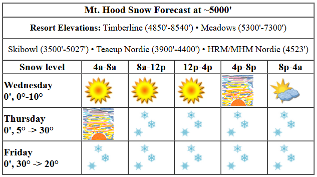
Up on the mountain for Wednesday? It’s a very rare green wax for the Nordic areas transitioning to blue-green mix later. Ditto on the alpine slopes – wax correctly, or you’ll feel the resistance! Snow conditions will be cold continental hardpack all day long. The freezing level will be 0′ all day with temps in the low single digits early and teens (at best) later. High clouds arrive late in the day. Wind will be E 10-15 in the morning, SE 20 in the afternoon, and SSE 20-35 overnight.
Thursday starts cloudy and quickly turns snowy. The snow level will be 0′ (yes, at your house too!) all day long with temps rising from the single digits in the morning to 20ish in the afternoon and the low 30s overnight. Models still haven’t coalesced around a snow total. Let’s call it a couple inches during the day and a couple more overnight for 3-5” of increasingly dense snow. Wind will be SSE 20-35 in the morning, S 10-15 in the afternoon, and light/variable after midnight as the air masses struggle for dominance.
Snowfall continues on Friday. The effective snow level (based on temps) will be 4500′ early and will fall to 500-1000′ overnight. Temps will be below freezing all day: 30-32F in the morning, mid 20s in the afternoon, and right around 20F overnight. About 0.3” water equivalent (WE) is forecast during the day for 3-4” new. Another 0.1” to 0.2” WE is forecast overnight for a couple more inches of snow. Models are currently all over the place on wind speed, but they’re ramping up: the deterministic GFS has enough wind Friday afternoon to potentially take out all the lifts at Meadows. We’ll take another look at this tomorrow – I suspect that particular model is the outlier and is coming in stronger than the wind will eventually play out.
On to Saturday: sunny in the morning, cloudy in the afternoon, and snowy overnight. The snow level will be about 500′ in the morning, 2500′ in the afternoon, and 5000′ after midnight. Temps will be near 20F in the morning, in the upper 20s in the afternoon, and right around freezing overnight. A trace of snow is forecast during the day. That’s followed by a couple inches overnight. MUCH more powerful weather is forecast Sunday into Monday. There’s some concern early in this period for mixed precip, but temps should drop and give us LOTS of snow, several feet, Sunday into Monday. Fingers crossed this plays out the way it looks like it will from today’s perspective! Stay tuned. See you on the snow!
Liking this forecast?
Was that helpful? I knew it was! Guess what? All of this crucial work – from your personal wind and snow reports to the invaluable TATAS updates – is made possible by my relentless efforts. Maintaining this labor of love isn’t easy. Each daily forecast takes hours. Website hosting, weather model access, and back-end admin work takes time and money. That’s where you come in.
YOUR CONTRIBUTION MAKES A DIFFERENCE
- SUPPORT ACCURATE, HYPER-LOCAL WEATHER FORECASTING
- ENABLE ACCESS FOR ALL, EVEN THOSE WITH LESS MEANS
- SUPPORT A COOL HUMAN WHO WORKS HARD SO YOU CAN PLAY
Take a moment to click one of the buttons below. Donate $19.99 or more (how much does this forecast enhance your life?) and get the email in your inbox. Whether it’s a renewing subscription (auto-renew) or a one-time donation, every contribution makes a real difference. Help me keep this labor of love alive, so we can all continue playing, commuting, and living in the Gorge with peace of mind and the best weather forecasts possible. Thank you!


Hood River, Oregon 97031


GORGE WIND FORECAST

Hi friends! Easterlies continue today and Thursday will a real nuker on tap Thursday. Ensembles are coalescing around a switch from easterlies to westerlies (briefly, anyway) on Friday with a chance of “just enough” to get you on the water. Wednesday kicks off with pressures of 30.05/30.22 for a 0.17 offshore gradient. As I was writing this, both Stevenson and Iwash (Rooster) Rock were reading 37mph (for a wind chill reading of 8F). The wind holds all day and likely picks up to 40-50mph at Iwash. East of Viento, easterlies pick up to 15mph. River flow over the last 24 hours was 93-185kcfs, river temp is 38.30F, and high temp forecast is 31F with sunny sky. It’s way too cold to get on the river today and tomorrow. Please just don’t.
Thursday starts with 50-60mph at Iwash and 40-45mph at Stevenson. In the afternoon, the wind drops to 35mph at Stevenson and holds at Iwash. High temp: 27F with light snowfall all day. Friday starts with easterlies at 25mph at both of the usual windy spots. While there’s some variety in the ensembles still, especially about wind speed, it does look likely the wind will switch at least lightly onshore in the afternoon. If it does so, the high temp will be 39F under cloudy sky with snow in the morning and showery weather in the afternoon. Easterlies are likely to return for the weekend. Enjoy the sun today!
BARE BONES HOOD RIVER WEATHER FORECAST
Clear sky this morning with partly high cloudy sky tonight. Temps start in the teens and rise to the low 30s. Moderate easterlies. No rainbows. Thursday brings light snow all day. Temps start in the teens and rise to the upper 20s. Moderate easterlies. No rainbows. Friday will be snowy in the morning with showers in the afternoon. Temps start in the low 20s and rise to the upper 30s. Light easterlies in the morning. Moderate westerlies in the afternoon. No rainbows.
TEMIRA’S AWESOME TRAVEL ADVISORY SERVICE
(HYPERLOCAL COLUMBIA GORGE WEATHER FORECAST)
Good morning, neighbors! It’s another chilly one out there. We’ll dive into the cold-temp winners in a minute, but let’s have a quick pre-cap of the forecast: sunny today with a potentially pretty sunset tonight; light snow most of the day tomorrow; light snow Friday morning potentially transitioning to light rain in the lowlands as we maybe see west wind in the afternoon; dry weather Friday morning followed by hmm, well, depends on initially conditions for Saturday. Probably some snow Saturday night followed by some potential for ice on Sunday. Honestly, we really need Friday’s forecast to solidify before we can tackle the weekend – things are right on the edge of “giant mess” territory at this point.
GLENWOOD AND THE TATAS EOTD
On to our morning winners: Glenwood takes the prize once again with a morning low of -6F. Stevenson, where’s it’s 26F and blowing 37mph, has a dewpoint of 11F. Ski resorts: 0-5F. Hummingbird feeders: frozen unless you have a heated one! Next, the TATAS Executive Order Of The Day: All congressional districts shall be drawn by objective outsiders; penalties for Gerrymandering shall be more than a slap on the wrist. Signed with a yellow highlighter, because, why not?
MINNESOTA MEAL MENU
Today’s weather: damned fine… for Minnesota! Here’s your Minnesota Meal Menu for the day from a real Minnesotan: hamburger hotdish with noodles (the ones that look like circles) and chow mein. Enjoy!
WEDNESDAY
We’ll have sunshine most of the day with a few high clouds later. Temps rise to the low 30s in the lowlands and the teens up high. East wind rises to 50mph or so near Iwash and holds at 35-40mph near Stevenson. East of Viento, the wind rises to 10-15mph, and in the east-facing foothills (Dufur, for example), you’ll find pesky easterlies at 15-25mph. High clouds stream in overnight, hopefully in time for a spectacular sunset, although we’ll need a gap in the clouds to the west to make it happen. NWS should un-cloud-seed the clouds over the west side to give us that gap!
THURSDAY
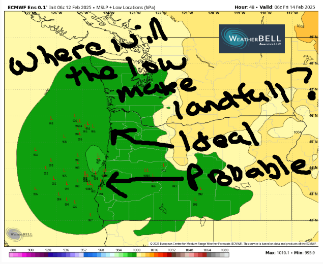
If you’re up before dawn on Thursday, you’ll find dry weather and cloudy sky. A bit after sunrise, light snowfall kicks in. As of this morning, models have the low coming inland just south of Florence, which is a bit too far south for complete chaos. Plus, there’s not all that much moisture associated with it. All that said, models give us 1-2” of snow by Thursday evening with 1-2” of additional snow overnight. With the system coming from the SSW, all areas, all the way east to the Tri-Cities, will pick up at least a little snow. Totals will be heaviest to the south, in South Wasco, west of Mosier, and in Parkdale. Thanks to cloud cover, temps on max out in the upper 20s after a 15-20F start. Wind: absolutely nuking near Iwash with 50+ mph wind all day. Stevenson starts with 40-45mph and drops to 35mph. South Wasco County sees easterlies at 15-20mph with blowing and drifting snow. Sadly, I don’t think we’ll get my favorite weather thing, a Blizzard Warning, from NWS despite the combo of snow and wind in the western Gorge – it’s just not going to be snowing hard enough to take visibility down to criteria level.
In the metro area and Valley Of Willies: chaos, as an entire INCH (maybe two) of snow falls starting during the morning commute. That switches to freezing rain and makes even more of a mess. Stay far, far away.
FRIDAY
The associated low pressure system slides inland on Friday. This is where the forecast gets tricky. If it holds together enough, has strong enough wind associated with it, and is followed by offshore high pressure that builds far north enough, we’ll see the wind turn onshore Friday, warming us up. We’ll also see the cold air get scoured out from above. If this all comes together (and models are hinting it will), most of the cold air will go bye-bye. This gives us a forecast of morning snow and afternoon drizzle (snow above 1000′). But… there’s still a wide range of possibilities for all those factors, so don’t count on a warm-up quite yet. Just know that it’s more likely than it was yesterday.
SATURDAY AND BEYOND
Friday’s fun is followed by dry weather most of the day Saturday. Precipitation returns in the afternoon or evening and carries more of a punch than the Thursday-Friday system. Everything’s kinda up in the air right now – the weather for Sunday into Monday depends completely on the initial conditions left by that Friday system. There’s certainly potential for snow, sleet, and freezing rain from Saturday night on through the weekend, but there’s no way to be precise about a forecast yet. I can say that it’ll be dumping snow in the mountains during that time period. That is all for now. Safe travels. -TATAS
HEY! DON’T STOP READING! Is this community-focused forecast helpful to you? It sure is! It takes me a couple hours a day to write. Please join your friends and neighbors in contributing to keep it going. Venmo: @thegorgeismygym PayPal: [email protected] USPS: Temira / PO Box 841 / Hood River, Oregon 97031 You can test out the forecast subscription for a few days for free by clicking this link: https://subscribepage.io/YhevGc

Leave a Reply