

MT. HOOD WEATHER FORECAST
Hey skiers and snowboarders! Models exceeded the forecast by a couple inches over the last 24 hours – Skibowl and Meadows are both reporting 10” of dry powder, champagne powder, blower pow… whatever you want to call it, it’s good snow. Groom and park and Nordic will all be cold packed powder today. Nordic: blue wax. Over the next several days, we’ll pick up trace amounts of snowfall, perhaps a total of 6” by Sunday, which looks like a sunny one. Snow chances return to the models around next Thursday, but there’s a huge range (none at all to feet), so all we can do for now is watch, wait, and ride the snow we’ve got!
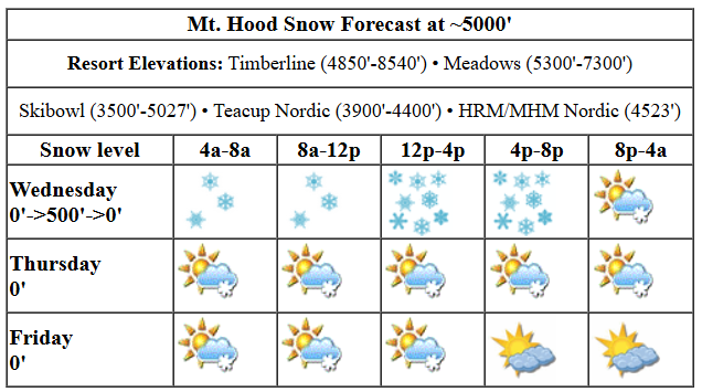
THURSDAY
Thursday will be mostly cloudy all day with the potential for some flurries during the day and light easterly orographic snowfall overnight. The snow level will be 0′ with temps in the teens at 5000′ all day. If we get really lucky, we’ll pick up an inch or two of fresh snow overnight, but I’d say the chances are low. Wind will be variable to 10 this morning, E 10-15 this afternoon, and NE 20 after midnight.
FRIDAY
Clouds and possibly flurries Friday morning give way to a bright, dry, and sunny afternoon. High clouds return overnight, and so does the potential for light snowfall, perhaps half an inch to an inch. The snow level / freezing level will be 0′ all day near Mt. Hood with temps right around 20F at 5000′. Wind: NE 20 in the morning, WNW 20-25 in the afternoon, and W 20-25 after midnight.
THE WEEKEND
On to the weekend… Saturday brings light snowfall under cloudy sky with clearing overnight. The snow level will be around 500′ all day with temps at 5000′ in the low 20s. About 0.1” to 0.2” water equivalent (WE) falls during the day for 1-3” of dry powder. Overnight: a trace of new. Wind will be W 15 all day and light/variable overnight. Sunday looks sunny and dry with temps in the low 20s and light/variable wind.
NEXT WEEK
Much colder weather is in the cards for Monday, Tuesday, and possibly Wednesday. Also forecast: SUNSHINE! Beyond that, there’s quite a bit of range in the ensembles; some have LOTS of precip, and some have zero. From this far out, with only low-res models to view, it does appear that the precip will stay snow, however much we get. That’s a good start, eh? See you on the snow!
Liking this forecast?
Was that helpful? I knew it was! Guess what? All of this crucial work – from your personal wind and snow reports to the invaluable TATAS updates – is made possible by my relentless efforts. Maintaining this labor of love isn’t easy. Each daily forecast takes hours. Website hosting, weather model access, and back-end admin work takes time and money. That’s where you come in.
YOUR CONTRIBUTION MAKES A DIFFERENCE
- SUPPORT ACCURATE, HYPER-LOCAL WEATHER FORECASTING
- ENABLE ACCESS FOR ALL, EVEN THOSE WITH LESS MEANS
- SUPPORT A COOL HUMAN WHO WORKS HARD SO YOU CAN PLAY
Take a moment to click one of the buttons below. Donate $19.99 or more (how much does this forecast enhance your life?) and get the email in your inbox. Whether it’s a renewing subscription (auto-renew) or a one-time donation, every contribution makes a real difference. Help me keep this labor of love alive, so we can all continue playing, commuting, and living in the Gorge with peace of mind and the best weather forecasts possible. Thank you!


Hood River, Oregon 97031


GORGE WIND FORECAST

Hi friends! East wind today, west wind tomorrow, and then back to easterlies on Saturday. You can probably put the watersport gear away for the Tuesday-Thursday window next week as models are calling for much colder weather. Let’s take a gander at Thursday: we start with light offshore pressures and 20mph at Iwash with 10mph at Stevenson. Models nudge the breeze to 35mph at Iwash (Rooster) Rock and 25-30mph at Stevenson later morning. Afternoon: 30-35mph at Iwash and 25mph at Stevenson. River flow over the last 24 hours was 87-132kcfs, river temp is 39.20F, and high temp forecast is 36F under increasingly cloudy sky.
Friday kicks off with easterlies under 10mph in the usual spots and calm wind everywhere else. As a low moves inland well to the south of us, west wind picks up. We should see gusty 15-18mph from Stevenson to Swell for a few hours in the afternoon before the wind shifts eastward with the same strength. High temp: 38F with cloudy sky to the west and sun to the east, at least in the afternoon. Saturday brings easterlies at 20mph in the morning, but they’ll quickly drop to 10mph or less and stay here. High temp: 41F (?) and cloudy. Stay safe out there!
BARE BONES HOOD RIVER WEATHER FORECAST
Clouds this morning and more later. Temps start in the low 30s and rise to the mid 30s. Light easterlies. No rainbows. Friday will be cloudy. Temps start in the mid 20s and rise to the upper 30s. Light easterlies early. Light to moderate westerlies later. No rainbows. Saturday will be cloudy with light snowfall early. Temps start in the upper 20s and rise to the upper 30s. Calm wind. No rainbows.
TEMIRA’S AWESOME TRAVEL ADVISORY FORECAST (HYPERLOCAL GORGE WEATHER FORECAST)
Good morning, neighbors! Let’s continue with winter, shall we? In the spirit of living in the present moment, I offer up several “Last Chance” opportunities for snow and cold weather. Before we dive in, let’s check in with little Glenwood this morning…
Glenwood is slacking in the cold department today: 24F with a dewpoint of 19F. Many, many other places are colder. For example, Trout Lake and Goldendale both achieved 20F this morning. Next, our TATAS Executive Order Of The Day: It doesn’t matter where you are from. As long as you meet age requirements and have insurance, you can get a driver’s license. Signed with a glitter pen!
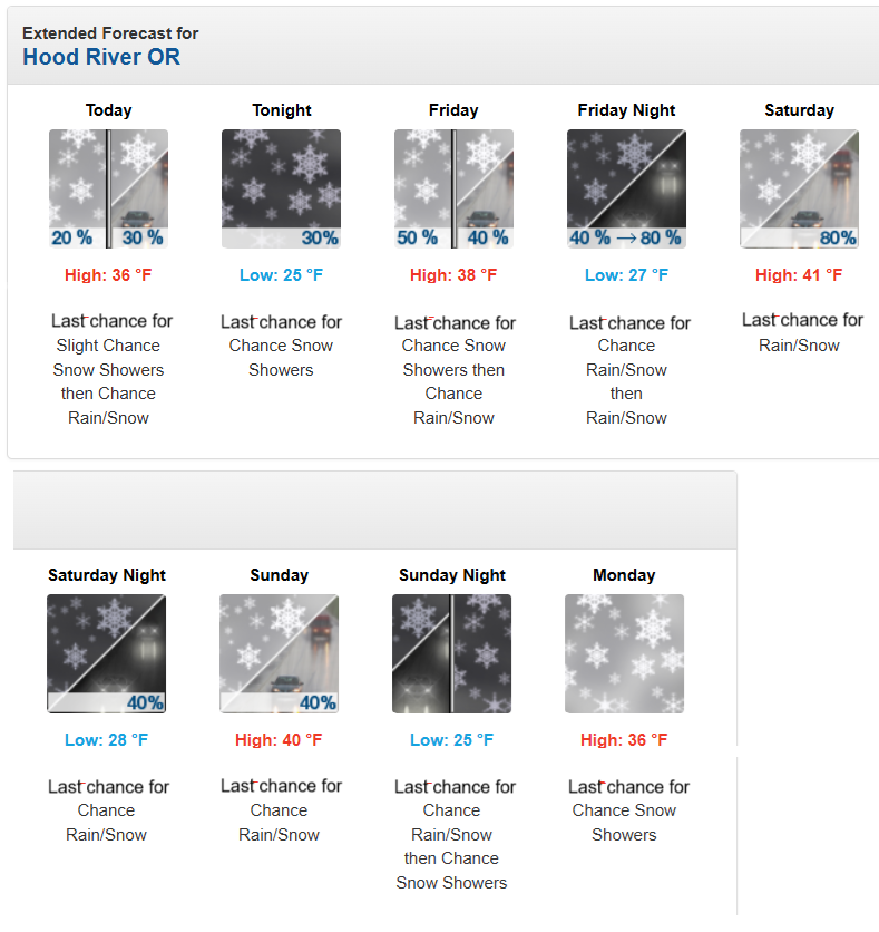
TODAY
Weather today: rather cloudy, but pretty much dry. EXCEPTION: south Wasco and Sherman Counties (SW/Sherm) will see light snowfall tonight with probably less than an inch total accumulation. You can thank the atmospheric river to the south of us for that. Snowfall doesn’t look to extend north past the Nch’i Wana (Columbia River, soon to be renamed River McRiver Face) or west of Cascades, at least not in the Gorge. Temps today max out in the mid 30s, and easterlies pick up to 30mph near Stevenson and Iwash (dick) Rock, where’s it’s WAY too cold to dangle your c*ck in the wind at the nude beach.
FRIDAY
A cloudy start to Friday gives way to clouds in the west and sun in the east. Before that happens, SW/Sherm will see light snowfall. If the system over-performs, we could see light snowfall along the Big River (that’s what Nch’i Wana translates to) east of The Dalles. High temp: upper 30’s. Wind: light easterly in the morning with westerlies at 15-20mph from Stevenson to Hood River in the afternoon and Stevenson to Amayah’s Indian Curry and Kababs (the location formerly known as Biggs) in the afternoon. Speaking of Amayah’s, yesterday I tried to convince the local public transport folks to run a bus there from Hood River, but they declined.
Also yesterday – a bunch of random LGBTQ+ folks in a coffee shop in Hood River and I (gender=X) were talking about how many of us have taken heartbreaking steps to make our identification safer (changing from X to F/M, etc). It’s sad times: it’s getting less and less safe to be our authentic selves. Hopefully y’all will step up to support and protect me and others as needed as things get worse.
THE WEEKEND
Weekend forecast: Overnight Friday into Saturday morning, we’ll have some light snowfall as far east as Biggs. Totals will be a trace to 2”, highest in the west. Saturday eventually becomes mostly cloudy in the west with partly cloudy sky, sunbreaks, and spectacular scenery to the east. Wind: light easterly. High temps along the river: upper 30s. Sunday looks like a Nothing day down here in the lowlands, but you can hop on the CAT bus and hang at Meadows if you’re seeking sunshine.
AND BEYOND…
Models drag in colder, or maybe much colder air for the first part of next week. I’M STILL WAITING FOR THE HOOK TO FREEZE SO I CAN SKATE, DAMNIT. The potential for “interesting” weather rises like a phallus encountering me (I’m sexy and I know it) as we approach Thursday. 40% of the Euro ensemble members have significant moisture encountering the entrenched cold air, and about 80% of the GFS members do the same. Vote for the moistest outcome. Ew. “Moistest” is even nastier than “moist” in terms of how it feels when I say or type it.
Anyway… enjoy all these last chances for snow and cold weather. If you don’t, you may have regrets when summer rolls around with 100+ degrees. Safe travels. -TATAS
HEY! DON’T STOP READING! Is this community-focused forecast helpful to you? It sure is! It takes me a couple hours a day to write. Please join your friends and neighbors in contributing to keep it going. Venmo: @thegorgeismygym PayPal: [email protected] USPS: Temira / PO Box 841 / Hood River, Oregon 97031 You can test out the forecast subscription for a few days for free by clicking this link: https://subscribepage.io/YhevGc
