MT. HOOD WEATHER FORECAST

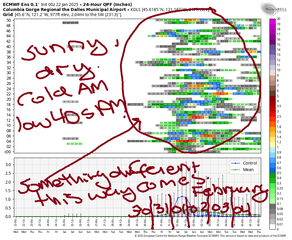
Hey skiers and snowboarders! Our long dry spell continues for another week or so – keep the sunscreen handy. Models are holding on to a pattern change towards the end of next week; it could come as early as Wednesday, but it’s more likely to come closer to Friday. Pinning down temps, precip, wind, or any other detail isn’t possible yet, but hey, it’s something different to look forward to!
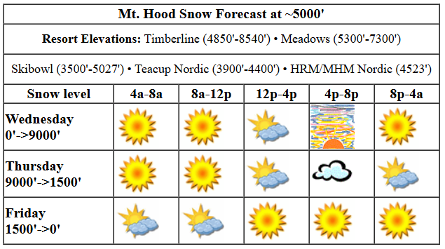
For Wednesday, we’ve got more of the same. If you’ve been enjoying the sunshine and awesome groom (especially the skategroom), you’ll have another round today. Snow conditions are frozen granular with areas of loose granular atop a firm base. The free air freezing level today starts at 0′, rises to 5000′, and climbs to 9000′ after midnight. Temps start right around 30 degrees at 5000′ and rise to 40 degrees this afternoon. Wind will be N 10 early, light/variable in the afternoon, and light NW after midnight.
Thursday starts sunny and turns high overcast before clearing overnight. The free air freezing level will be 9000′ in the morning, 8500′ in the afternoon, and it’ll fall to 1500′ after midnight with the passage of a weak, dry system. Temps start in the upper 30s and fall to the upper 20s in the afternoon. We can’t rule out a few flurries overnight, but measurable snowfall is unlikely. Wind: Light NW in the morning, NW 15-20 in the afternoon, and N 10+ after midnight.
Liking this forecast?
Cool air pushes in Friday thanks to the passage of that system. A few flurries are possible, but ensembles, even at the 90th percentile, have less than half an inch of snow. A few low clouds start the day, but plenty of sunshine is forecast as well. The free air freezing level will be 1500′ in the morning, 1000′ or less in the afternoon, and 0′ after midnight. Temps start in the mid 20s and fall to 20F or so. Wind: N 10+ early, NE 25 in the afternoon, and ENE 25 after midnight.
For the weekend, we’re looking at sunny weather. Saturday will be cold – teens to start and mid 20s to finish. East wind at 30mph is forecast Saturday, which could shut down Timberline. It’s more affected by the easterlies than the other resorts. Lingering easterlies Sunday morning back off in the afternoon. Temps on Sunday rise to 40 degrees or so under sunny sky. Sunny, above-freezing weather is forecast to stick around on the slopes through much of next week. As I mentioned before, something different finally happens starting around next Friday. I’ll be on retreat through next Wednesday, so stick with this persistence forecast. We’ll revisit the pattern change when I return. Enjoy the sunny slopes!
Was that helpful? I knew it was! Guess what? All of this crucial work – from your personal wind and snow reports to the invaluable TATAS updates – is made possible by my relentless efforts. Maintaining this labor of love isn’t easy. Each daily forecast takes hours. Website hosting, weather model access, and back-end admin work takes time and money. That’s where you come in.
YOUR CONTRIBUTION MAKES A DIFFERENCE
- SUPPORT ACCURATE, HYPER-LOCAL WEATHER FORECASTING
- ENABLE ACCESS FOR ALL, EVEN THOSE WITH LESS MEANS
- SUPPORT A COOL HUMAN WHO WORKS HARD SO YOU CAN PLAY
Take a moment to click one of the buttons below. Donate $19.99 or more (how much does this forecast enhance your life?) and get the email in your inbox. Whether it’s a renewing subscription (auto-renew) or a one-time donation, every contribution makes a real difference. Help me keep this labor of love alive, so we can all continue playing, commuting, and living in the Gorge with peace of mind and the best weather forecasts possible. Thank you!


Hood River, Oregon 97031


GORGE WIND FORECAST

Hi friends! Easterlies are back this morning. They’ll stick around in some form today, tomorrow, and the weekend. Not much at all happens on Friday other than a rest day for you and a travel day for me. Wednesday starts with very light offshore gradients: just E0.01 when I got up. Easterlies in the pre-dawn hours were 10mph at Stevenson and 20mph at Iwash (Rooster) Rock. The wind picks up to 35mph at Iwash this afternoon and rises to 25mph at Stevenson. River flow over the last 24 hours was 119-173kcfs, river temp is 41.36F, and high temp forecast is 42F with mostly clear sky.
Thursday starts with E 45 at Iwash and 20-25mph at Stevenson. The wind drops to 15-20mph at both places late morning and continues to fall into the evening, eventually turning westerly overnight. High temp: 42F with sun in the morning and high clouds in the afternoon. If you could shred in the dark, there might be enough wind overnight. By Friday morning, westerlies will be 10mph or less. The wind turns to easterlies at 10mph or less in the afternoon. High temp: 41F with clouds in the morning and sun later.
BARE BONES HOOD RIVER WEATHER FORECAST
Clear sky starts the day. Some high clouds join later. Temps start in the mid 20s and rise to the low 40s. Easterlies. No rainbows. Thursday starts clear and turns high overcast. Temps start in the mid 20s and rise to the low 40s. Easterlies. No rainbows. Friday will be cloudy then clear. Temps start in the upper 20s and rise to the low 40s. Light westerlies early. Light easterlies later. No rainbows.
TEMIRA’S AWESOME TRAVEL ADVISORY SERVICE (DETAILED WEATHER FORECAST FOR THE COLUMBIA GORGE)

Good morning, neighbors! WYSIWYG for the next week or so – cold mornings, plenty of sunshine, and no precipitation at all. Models continue to hint at a pattern change at the end of next week, but deets are still unclear.
Before we dive into the forecast, let’s take a look at the center of the universe: Glenwood! This morning, that esteemed community is sporting a reading of 15 degrees with a dewpoint of 11 degrees. Good job, Glenwood! As we learned yesterday, this is plenty warm to take a wee off the deck. Get on it!
Today I’m adding a new fantasy section to the forecast: TATAS Executive Order Of The Day. You know, for my sanity. Today’s signature gives you… A buy-in option for Medicare on the Exchange. Alongside the (truly crappy) offerings by BCBS, Prov, Aetna, United Healthcare, and others, you’re now able to buy into Medicare. You’re welcome. Stay tuned for more of TATAS’ policies and procedures going forward.
TODAY
Today’s weather looks a lot like yesterday’s, only the wind will blow from the opposite direction: east rather than west. Easterlies rise from 20mph at Iwash (dick) Rock to 35mph this afternoon. Stevenson and Cascade Locks: you start with 10mph and finish with 25mph. Up in the hills, the wind should be lighter, and up on the ski slopes, it’ll be basically calm by afternoon. Valley temps max out in the low 40s today with mostly clear sky. Ah, sunshine, what a blessing you are!
THURSDAY
Guess what Thursday brings? Yep, you got it. Another cold morning. Another low-40s afternoon. Sunshine in the morning gives way to high clouds in the afternoon. For your commute to the metro area in the morning, you’ll have 45mph east wind at Iwash (dong) Rock. The wind drops below 10mph in the afternoon there and everywhere.
FRIDAY
Overnight and into Friday morning, a very weak and highly un-impactful weather system swings through. A few snow flurries are possible, but they’re also not likely, and neither will we see enough snow to make a mess of things. Even the ensembles for the 90th percentile have 0.3” snow, and that’s only on the peak of Mt. Hood, where you won’t be and neither will I. Friday’s temps start in the upper 20s along the river and rise to the low 40s. Low clouds on the west side combine with a sunny start to the east, but we’ll all end up sunny by afternoon. Wind will be light westerly early and light easterly later in the lowlands. Up in the hills, we’ll see the wind pick up to NE 10-25 depending on elevation.
THE WEEKEND
For the weekend, we have the same weather we’ve had all week: sub-freezing start, low 40s to finish, sunshine, east wind in the lowlands. For the most part, that same weather continues at least through next Wednesday and possibly into next Friday. This is reassuring to me, as I’ll be gone starting Friday and won’t be worrying about missing almost a week of forecasts. Not sure what to do about my executive orders, though. Maybe I’ll issue a flurry of them when I get back from my retreat. Safe travels. -TATAS
HEY! DON’T STOP READING! Is this community-focused forecast helpful to you? It sure it! It takes me a couple hours a day to write. Please jump in a contribute to keep it going. Venmo: @thegorgeismygym PayPal: twomirrors@gmail.com USPS: Temira / PO Box 841 / Hood River, Oregon 97031 You can test out the forecast subscription for a few days for free by clicking this link: https://subscribepage.io/YhevGc


