MT. HOOD WEATHER FORECAST

Hey skiers and snowboarders! With the exception of a touch of snow this week Thursday into Friday, we’re probably waiting until the end of the month for the fresh tracks to return. We’ll have some variety in the old-snow skiing – some days will be cold, and some days will be warm. Well, you know my take on this – skate skiing is super-fun on old snow. So, now’s a good time to take it up!
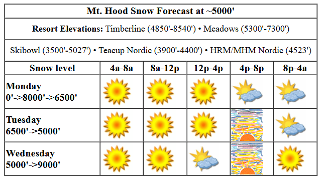
Monday kicks off cold and clear with upper teens on the alpine slopes and single digits to low double digits down in the Nordic zones. The free air freezing level rises from 0′ this morning to 8000′ this afternoon and 6500′ tonight. Temps at 5000′ rise to the upper 30s today under sunny sky. High clouds move in later. Wind will be E 15 this morning, light westerly this afternoon, and W 25 after midnight.
Clear sky starts the day on Tuesday, and high clouds move in during the afternoon. The free air freezing level will be 6500′ in the morning, and 5000′ for the afternoon and evening. Temps max out a degree or two above freezing. Wind: W 25 in the morning, NW 25-30 in the afternoon (enough to take out the most exposed lifts like Cascade and Vista), and light northerly overnight.
Liking this forecast?
Wednesday will be sunny in the morning and high overcast in the afternoon. The free air freezing level rises from 5000′ in the morning to 7000′ in the afternoon to 9000′ after midnight. Temps climb from the low 30s to the low 40s. Wind will be light northerly all day.
A sunny, warm day is in the cards on Thursday prior to the passage of a weak system overnight. The free air freezing level will be 9000′ with temp sin the mid to upper 40s. Wind: light westerly in the morning, W 25 in the afternoon, and NW 25-30 overnight.
Models bring in colder weather with a chance of a little snow on Friday: anything from a trace to a couple inches. Given the dry air in place and lack of moisture with this system, the lower end of that range is more likely than the high end. While there’s some disagreement about the exact details of the forecast through the weekend and the following week, then general picture calls for dry weather. Whew. This is one seriously long dry spell we’re having. Toss your sunscreen in the car and get up there!
Was that helpful? I knew it was! Guess what? All of this crucial work – from your personal wind and snow reports to the invaluable TATAS updates – is made possible by my relentless efforts. Maintaining this labor of love isn’t easy. Each daily forecast takes hours. Website hosting, weather model access, and back-end admin work takes time and money. That’s where you come in.
YOUR CONTRIBUTION MAKES A DIFFERENCE
- SUPPORT ACCURATE, HYPER-LOCAL WEATHER FORECASTING
- ENABLE ACCESS FOR ALL, EVEN THOSE WITH LESS MEANS
- SUPPORT A COOL HUMAN WHO WORKS HARD SO YOU CAN PLAY
Take a moment to click one of the buttons below. Donate $19.99 or more (how much does this forecast enhance your life?) and get the email in your inbox. Whether it’s a renewing subscription (auto-renew) or a one-time donation, every contribution makes a real difference. Help me keep this labor of love alive, so we can all continue playing, commuting, and living in the Gorge with peace of mind and the best weather forecasts possible. Thank you!


Hood River, Oregon 97031


GORGE WIND FORECAST

Hi friends! The battle of offshore high pressure vs. inland high pressure continues way out into the end of this month. With this setup in place, easterlies will be favored, but any system that comes through is likely to swing the wind onshore, westerly, for a period of time. It’s Monday today, and the week kicks off with easterlies. And when I say “easterlies”, I mean all the way up to the ski slopes thanks to a very deep cold pool. This, unfortunately, has the tendency to knock the speed down on the river, at least to start. The day starts plenty wind, tho: 30-40mph at both Iwash and Stevenson with low 20s at Viento. At Iwash, the wind holds today, and maybe picks up a touch this afternoon as the easterlies stop spilling over the top of the Cascades. At Stevenson, the wind drops to 20-25mph this afternoon. River flow over the last 24 hours was 119-169kcfs, river temp is 41.72F, and high temp forecast is 36F with sun in the morning and high clouds later.
Tuesday starts calm and turns light westerly as a dry system swings through. We’ll see 14-17mph from Stevenson to Hood River with calm wind to the east. Mosier could see 10-13mph, but it will be calm east of there or potentially even light easterly. High temp: 41F with sun in the morning and high clouds later. Wednesday starts with E 15-20mph at Stevenson and rises to 25mph. This holds through sunset. Iwash starts with 25mph and rises to 35mph. This also holds into the end of the day. High temp: 41F with sun in the morning and high clouds later. Thursday looks like another light to moderate westerly day. Not much is forecast Friday. We should be back to easterly for the weekend. Have fun out there – stay warm, and keep an eye on your buddies!
BARE BONES HOOD RIVER WEATHER FORECAST
Clear sky this morning adds high clouds later. Temps start in the mid 20s and rise to the mid 30s. Easterlies. No rainbows. Tuesday will be high clear then partially high overcast. Temps start in the mid 20s and rise to the mid 40s. Light westerlies. No rainbows. Wednesday will be clear then partly high cloudy. Temps start in the upper 20s and rise to the low 40s. Easterlies. No rainbows.
TEMIRA’S AWESOME TRAVEL ADVISORY SERVICE (DETAILED WEATHER FORECAST FOR THE COLUMBIA GORGE)

Good morning, neighbors! “Cold and dry” pretty much sums up the weather for the next ten days. Possible exception: Friday morning, when a few snowflakes are possible, but almost certainly nothing to cause any sort of chaos. But don’t you worry – there’s plenty of chaos coming in other domains of life.
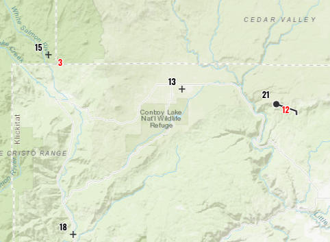
But first – GLENWOOD! In this morning’s “News of the Wholesome”, our cold spot dropped to 13F degrees last night with a dewpoint of 9F. You’d have to head to Teacup Nordic for colder – temps fell as low as 3F there last night, resulting in the balls freezing off the snow cat.
TODAY
It’ll be a chilly one down here today today: temps only rise to the mid 30s in the lowlands. Head to Stevenson for a windchill reading of 20F this morning; easterlies will be 30-35mph there this morning with 20-25mph in the afternoon. For even colder ambient temps, head to Iwash (dick) Rock where the wind will be 40mph most of the day. Perhaps you can take a video of the blowing spray and post it on Tik Tok, back thanks to the collapse of the separation of powers doctrine. Also, in a blatant example of what got Tik Tok banned by the Supreme Court is the welcome back message giving credit to a specific individual China is stoked to see in power.
TUESDAY
On to Tuesday’s weather. Clear and cold until a weak, dry weather system pushes in like a puppy checking out an old cat – tentative, right? This system does little more than 1) add some high clouds, 2) turn the wind onshore; and 3) jack up temps by 5-10 degrees. Westerlies rise to 15mph from Stevenson to Hood River, temps climb from the mid-20s early to the mid 40s midday, and some high clouds stream in.
WEDNESDAY AND THURSDAY
We’re back to sunshine and sub-freezing weather Wednesday morning. However, this time you’ll be able to head to the ski slopes for 40 degrees. East wind will be back: 25mph at Stevenson and 35mph at Iwash. A few high clouds stream in during the afternoon. If we’re lucky, they’ll be in just the right place for a pretty sunset. Thursday looks sunny, 40 degrees, with light west wind.
FRIDAY
Something different FIANLLY happens on Friday. A tiny bit of precipitation is possible west of Mosier and in the Dufur area. There won’t be much moisture, but there’s a non-zero chance of something falling from the sky for an 18-24 hour period. WOW! After that, we’re back to cold, dry, sunny weather for much of next week. That’s helpful, because you wont’ need me. And that’s good, because I”ll be on a meditation retreat.
Finally, as many of you know, many folks in this area have immigrated from other locations, mostly Mexico. Quite a few of those folks have been working their butts off for decades despite the fact that they don’t have papers. Keep them in your hearts today and going forward, and if you have the capacity to be part of an early warning system for ICE, please do so. One other thing: lots of people have been asking me if I’ll move this forecast to Bluesky and off Facebook, where it has resided for years. The answer is no. First, I don’t want to perpetuate a system that increases the divides between us. Everyone, no matter their beliefs, has the right to a good weather forecast, meaning my forecast, of course! For those accessing this forecast on Facebook who would like a different way to do so, the way to do that is right here on the website. Take care of each other today, okay? Safe travels. -TATAS
HEY! DON’T STOP READING! Is this community-focused forecast helpful to you? It sure it! It takes me a couple hours a day to write. Please jump in a contribute to keep it going. Venmo: @thegorgeismygym PayPal: twomirrors@gmail.com USPS: Temira / PO Box 841 / Hood River, Oregon 97031 You can test out the forecast subscription for a few days for free by clicking this link: https://subscribepage.io/YhevGc


